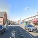
Clifton Street is a major commercial thoroughfare located in the inner-city ward of Adamsdown in Cardiff, Wales, situated approximately one mile east of the city centre and serving as the primary retail high street for the local residential population.
- How did Clifton Street develop from medieval farmland into an urban high street?
- What were the defining architectural and institutional anchors of historical Clifton Street?
- How did the economic profile of Clifton Street shift during the twentieth century?
- What structural changes did the Clifton Street Regeneration Strategy introduce?
- What is the contemporary socio-economic status of Clifton Street?
The street runs in a northwest-to-southeast direction, connecting Newport Road (A4161) at its northern terminus with Split Road and the railway boundary at its southern end. Administratively, Clifton Street is located entirely within the Adamsdown electoral ward under the local governance of the Cardiff County Council. The district is bounded tightly by main transport infrastructure corridors, with the main South Wales Railway Line running along the southern perimeter and Newport Road isolating it from the neighboring suburb of Roath to the north.
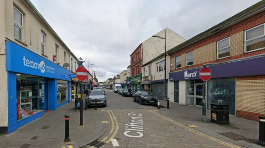
Architecturally, the street is characterized by continuous rows of Victorian-era terraced properties featuring commercial retail units on the ground floor and residential spaces or storage facilities on the upper levels. The surrounding residential grid consists of dense, linear streets built during the late nineteenth century. These residential streets are famously grouped by semantic themes, including astronomical names like Star Street, Constellation Street, and Eclipse Street, as well as precious metals and minerals such as Gold Street, Copper Street, Silver Street, and Metal Street. Clifton Street acts as the central economic spinal cord for this square mile of high-density housing, functioning structurally as a traditional ribbon development shopping district that caters directly to the immediate pedestrian catchment area.
How did Clifton Street develop from medieval farmland into an urban high street?
Clifton Street developed through rapid nineteenth-century industrialization, transforming from agricultural pastures known as the downs into a dense commercial corridor between 1850 and 1890 to house and serve workers migrating to the Cardiff docks and local ironworks.
During the medieval period, the land that contains modern Clifton Street lay entirely outside the eastern stone walls of Cardiff. The territory formed part of the extensive agricultural estates of the Lordship of Glamorgan. Historical records from 1331 indicate that the area was named after Adam Kyngot, who served as the porter and gatekeeper of Cardiff Castle. The lords of Glamorgan granted Kyngot the right to manage these extensive, gently undulating fields, which became known sequentially as Adam’s Down and eventually Adamsdown. For five centuries, this landscape remained strictly rural, dominated by two primary agricultural nodes: Adamsdown House and Adamsdown Farm. An estate map commissioned by the Bute Estate in 1824 confirms that the area was still managed as a single 270-acre agricultural tenancy, with fields extending south toward the Bristol Channel foreshore.
The catalyst for urban transformation occurred between 1830 and 1860, driven by the infrastructure expansions of the Marquesses of Bute. The opening of the Cardiff Gaol on nearby Outer Gaol Lane in 1832 and the establishment of an adjacent public cemetery in 1848 began the encroachment of institutional structures onto the farmland. The completion of the South Wales Railway Line in 1850 permanently bisected the Adamsdown estate, carving out a specific pocket of land north of the tracks for rapid residential development.
The expansion of the Bute East Dock in 1859 created an unprecedented demand for industrial labor, prompting the Bute Estate and private entities like the Cardiff Cottage Company to construct dense grids of working-class housing. Speculative builders established Clifton Street as the primary commercial spine of this new neighborhood during the 1870s. The street was deliberately wide to accommodate high volumes of horse-drawn cart traffic. By 1875, Ordnance Survey maps show the street completely plotted out with continuous terraced blocks, transitioning firmly from rural fields into a bustling, self-contained Victorian shopping ribbon designed to supply thousands of industrial manual laborers.
What were the defining architectural and institutional anchors of historical Clifton Street?
Historical Clifton Street was anchored by prominent Victorian public houses, commercial institutional buildings, and transport networks, including the Clifton Hotel, the Tredegar Hotel, a dedicated police station, and the terminal line for Cardiff’s horse-drawn tram system.
The physical and social infrastructure of Clifton Street during its late-nineteenth-century peak relied on several key architectural anchors. Public houses served as the primary social and economic headquarters for local workers. The Clifton Hotel, situated at the prominent northern corner of Clifton Street and Broadway, stands as one of the oldest commercial establishments in the district. Earliest documentary evidence found in local newspaper advertisements dates the establishment to August 1858. The building features a classic early-Victorian three-storey square plan with a faceted corner entrance, rendered pennant stone walls, and distinct stained-glass panels bearing the branding of regional brewers such as S.A. Brain and Company.
Further down the thoroughfare, at the intersection of Clifton Street and Pearl Street, the Tredegar Hotel was erected in 1872 at a cost of £2,000. Funded by the local developer Robert Thomas Meyrick on land leased from Lord Tredegar, this substantial three-storey structure was built using snecked pennant stone with brick quoins and housed 24 rooms, including a specialized skittle alley added in 1887.
Civic order and infrastructure matched the commercial growth of the street. In 1933, the local authority opened the Clifton Street Police Station to manage the densely populated inner-city district, constructing a robust stone facility that operated for decades as a regional sub-station. Transport infrastructure also utilized Clifton Street as a primary terminus. In 1903, the final horse-drawn tram service operated by the Cardiff Tramways Company made its historic final journey from its terminal point outside the Tredegar Hotel on Clifton Street, traveling directly down to the Dowlais Ironworks on the East Moors. This event marked the transition of the street into the modern electrical transit era, cementing its role as a well-connected transport hub.
How did the economic profile of Clifton Street shift during the twentieth century?
Clifton Street shifted from a highly prosperous retail hub dominated by national chains and specialist food purveyors in the mid-twentieth century to an independent, service-oriented street marked by post-industrial decline after 1970.
During the 1950s, Clifton Street operated as a premier regional shopping destination, drawing consumer foot traffic from surrounding residential areas such as Roath, Splott, and even distant suburbs like Llanrumney and Cowbridge. The economic profile of the street was characterized by a high concentration of specialized food retailers and major national multiple corporations. Historical business directories from this period document the presence of three major national grocery chains: Lipton’s, the Co-operative Wholesale Society, and Home and Colonial. The street exhibited a high density of specialized food trades, containing up to 15 independent butchers’ shops operating simultaneously, alongside multiple drapers, milliners, tailors, and shoe retailers. This retail mix allowed the street to function as an autonomous commercial ecosystem where residents could fulfill all material and dietary requirements within walking distance of their homes.
The economic stability of Clifton Street began to deteriorate rapidly during the late 1970s due to macro-economic transformations in the wider Cardiff region. The defining event was the permanent closure of the nearby East Moors Steelworks on April 28, 1978, which instantly eliminated over 4,000 industrial jobs and severely reduced the purchasing power of the Adamsdown community.
A retail study conducted by postgraduate researchers at Cardiff University documented the long-term impact of this industrial decline. By the early 1990s, the final multiple corporate supermarket, Lo Cost, closed its doors, leaving the premises to be converted into a smaller convenience format. A comprehensive health check of the street conducted in mid-2002 revealed that out of 110 available commercial premises, only 13 units remained in convenience retail use, while 41 were classified as comparison retail, 46 had transitioned into service industries such as takeaway food and betting shops, and 22 stood entirely vacant. The closure of iconic local institutions, including the Woolworths Local outlet and the long-standing Oliver’s shoe shop, signaled a permanent shift away from high-value retail toward a low-margin, localized service economy.
Explore More Area Guide
What Makes Wellfield Road One of the Best High Streets in Cardiff?
Newport Road Rumney: Complete Guide to the B4487 Corridor
What structural changes did the Clifton Street Regeneration Strategy introduce?
The Clifton Street Regeneration Strategy introduced structural alterations including a one-way traffic system, widened pedestrian pavements, new street furniture, and extensive shopfront modernizations funded by a £1 million local authority investment.
In response to the visible retail decline and high vacancy rates documented at the turn of the millennium, Cardiff County Council initiated the Clifton Street Regeneration Strategy in October 2007. The project represented a targeted municipal investment of £1 million aimed at upgrading the physical environment, improving pedestrian accessibility, and attracting independent commercial investment back into the Adamsdown core. The most significant structural intervention was the transformation of the vehicular traffic flow. The council eliminated the historical two-way traffic system, replacing it with a restricted one-way traffic system running from north to south. This modification allowed civil engineers to reclaim substantial portions of the asphalt roadway, utilizing the space to widen the pedestrian pavements on both sides of the street.
The engineering works also focused heavily on the visual identity and longevity of the historical building stock. The local authority deployed specialist conservation teams to sandblast and restore the traditional Victorian pennant stone facades of heritage structures, including the former Roath Police Station.
Additionally, the regeneration program provided direct financial grants to local property owners to replace deteriorated shopfronts with uniform, modern alternatives featuring integrated security shutters and updated signage. New public infrastructure was installed throughout the corridor, consisting of high-efficiency street lighting, modern litter bins, and decorative bollards designed to prevent illegal pavement parking.
However, the execution of the physical works caused significant short-term economic disruption. Local traders organized under the Clifton Street Traders Association reported that the prolonged presence of heavy machinery, construction barriers, and the sudden elimination of convenient on-street parking spots caused a drop in immediate foot traffic. This disruption led directly to the closure of seven independent shops during the active construction phase, highlighting the friction between long-term urban remodeling and immediate retail survival.
What is the contemporary socio-economic status of Clifton Street?
Clifton Street operates as a highly diverse, independent commercial district characterized by multicultural convenience shops, international food venues, and community-led regeneration frameworks addressing modern inner-city challenges.
Clifton Street functions as the multi-ethnic commercial heart of Adamsdown. The contemporary retail landscape contains almost no national corporate multiples, relying instead on a dense network of independently owned businesses that serve a highly diverse local demographic. The street features a prominent concentration of international grocery stores, halal butchers, traditional barbers, and multicultural restaurants reflecting the demographic shifts within the inner-city ward of Cardiff. These independent units provide essential access to specialized foods and affordable household goods for a low-income population. The physical infrastructure continues to rely on historical assets, such as the Spar convenience grocery store operating out of the old Lo Cost supermarket premises, alongside various community service providers, advice centers, and charitable organizations.
The community infrastructure surrounding the street has been formalised through frameworks such as the Adamsdown Community Project, which grew out of local neighborhood forums. These groups consistently lobby municipal authorities to address ongoing urban challenges, including high business rates, commercial waste management, and the preservation of upper-floor spaces for affordable residential use.
The social value of the street’s built heritage remains highly recognized by the local authority. Under the Cardiff Local Development Plan, key historic assets like the former Clifton Hotel and the vacant Tredegar Hotel building are subject to strict planning protections. Although the Tredegar Hotel closed permanently in 2006 and suffered physical deterioration, current municipal planning frameworks focus on preserving its external pennant stone architecture while facilitating its adaptive reuse into residential apartments. This ongoing transition from a traditional working-class retail high street to a multicultural, residential-led service hub demonstrates the resilience of Clifton Street as it adapts to twenty-first-century urban realities.
Where is Clifton Street located in Cardiff?
Clifton Street is located in the Adamsdown area of Cardiff, around one mile east of the city centre. It runs from Newport Road (A4161) to Split Road and serves as the main shopping street for the local community.