Cardiff is widely recognised as the capital of Wales, but its modern urban landscape contains numerous settlements that existed long before the city reached its present boundaries. Historic villages such as Llandaff, St Fagans, Lisvane, Llanishen, Radyr, Old St Mellons and Pentyrch retain evidence of earlier rural, religious, agricultural and industrial communities.
- What were Cardiff’s old villages before the city expanded?
- How did Llandaff become one of Cardiff’s most historic villages?
- Why is St Fagans important when exploring Cardiff’s village history?
- What makes Radyr and Morganstown significant historic settlements?
- How does Lisvane preserve Cardiff’s rural village character?
- What does Llanishen reveal about Cardiff’s transition from village to suburb?
- Why should visitors explore Old St Mellons when discovering Cardiff’s villages?
- How did Pentyrch and Gwaelod y Garth develop from rural communities?
- How can visitors experience Cardiff’s old villages today?
- Why do Cardiff’s old villages still matter to the city’s future?
These places developed around churches, farms, estates, rivers, roads, railway lines and industrial sites. Their histories explain why Cardiff contains such a varied architectural and cultural landscape today.
Cardiff Council currently identifies 27 conservation areas, around 1,000 listed buildings, approximately 300 locally listed buildings, and 31 scheduled monuments across the city. These designations demonstrate the scale of Cardiff’s surviving historic environment.
Discovering Cardiff’s old villages therefore involves more than visiting old buildings. It involves understanding how separate communities became part of a growing capital while retaining distinctive historic identities.
What were Cardiff’s old villages before the city expanded?
Cardiff’s old villages were separate rural, religious, agricultural and industrial settlements that developed around churches, farms, estates, roads and rivers before urban expansion connected them to Cardiff. Llandaff, St Fagans, Radyr, Lisvane, Llanishen, Old St Mellons and Pentyrch provide clear examples today.
Cardiff did not develop as one continuous urban settlement. The modern city grew through the gradual expansion of an older town and the incorporation of surrounding communities.
Many historic settlements were originally organised around a parish church. Others developed around agricultural estates, market routes, mining areas, ironworks or railway infrastructure.
The River Taff was particularly important to western Cardiff. It connected communities such as Llandaff and Radyr with Cardiff and provided routes for movement and trade.
Northern and north-western settlements retained stronger rural characteristics for longer. Lisvane, Llanishen and Pentyrch contained farms, open land and village settlements before extensive housing development transformed their surroundings.
Eastern communities followed a different pattern. Old St Mellons developed along the historic route between Cardiff and Newport. Its position gave the settlement an important connection with travellers and road traffic.
The boundaries of Cardiff expanded as the population increased and infrastructure developed. Llandaff, for example, became part of Cardiff in 1922 after centuries of maintaining a distinct ecclesiastical and village identity.
The result is a city containing layers of settlement history. A modern residential road can sit close to a medieval church, historic farmstead or older village street.
How did Llandaff become one of Cardiff’s most historic villages?
Llandaff developed around an early Christian settlement and cathedral, becoming an important ecclesiastical centre by the medieval period. Its medieval street pattern, cathedral precinct, Bishop’s Palace remains, village green and historic buildings preserve evidence of its long development before incorporation into Cardiff.
Llandaff has one of the deepest historical records among Cardiff’s surviving communities.
The Cathedral of Llandaff records a Christian presence on the site from at least the sixth century. Early medieval evidence includes a late tenth- or early eleventh-century cross and grave markers incorporated into the cathedral fabric.
The present cathedral developed substantially during the Norman period. Bishop Urban began rebuilding the cathedral around 1120. Later medieval bishops expanded the complex, creating the architectural foundations visible today.
Llandaff became the centre of a Norman lordship. The settlement included religious, administrative and residential functions. Its importance was closely connected with the cathedral and the authority of the Bishop of Llandaff.
The village green remains a major feature of the historic environment. The area contains the ruined Bishop’s Palace and Bell Tower, while the cathedral forms the principal architectural landmark.
Llandaff’s historic street pattern is particularly significant. Cardiff Council’s conservation appraisal describes the settlement as having developed organically around a medieval street pattern.
The village expanded more rapidly during the eighteenth and nineteenth centuries. Wealthy industrial families built substantial houses as Cardiff’s economy grew. Insole Court provides an important example of this later period.
The nineteenth century also brought major restoration work to Llandaff Cathedral. Cardiff’s expanding urban population eventually surrounded the historic settlement.
Llandaff became part of Cardiff in 1922. Its incorporation did not erase its separate physical character. The cathedral precinct, village green, historic buildings and older street network remain clearly identifiable within modern Cardiff.
Why is St Fagans important when exploring Cardiff’s village history?
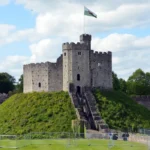
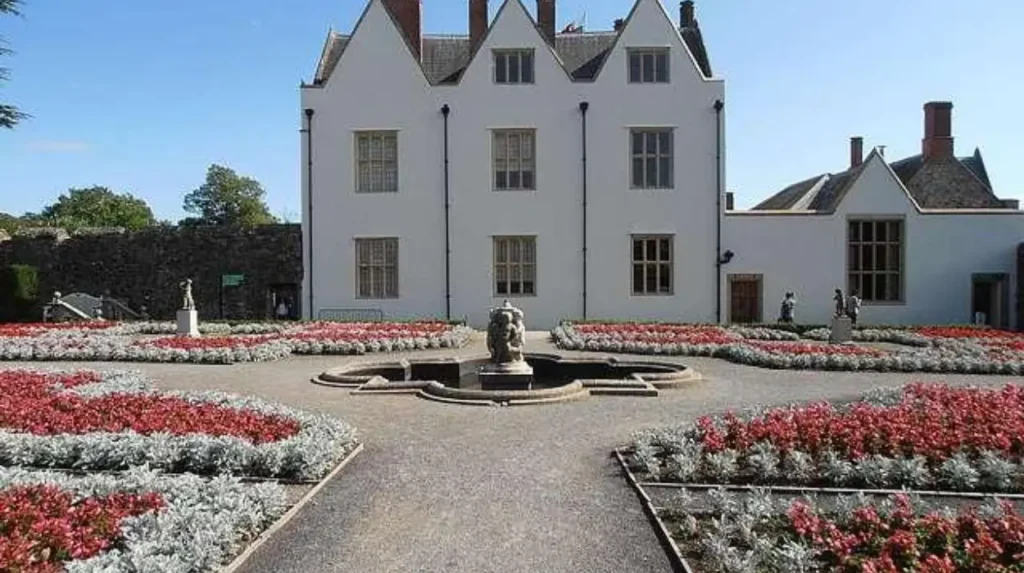
St Fagans preserves the relationship between a historic village, country estate, castle and Welsh social history. Its castle occupies the site of a Norman motte and bailey, while the National Museum of History preserves traditional buildings and records from communities across Wales.
St Fagans is one of Cardiff’s most important heritage locations because its history extends beyond a single building.
The earliest castle on the site was constructed by Norman lord Robert le Sore during the twelfth century. The original timber and earth motte and bailey was later rebuilt in stone during the fourteenth century.
The present St Fagans Castle developed from the late sixteenth century. Construction of the mansion began around 1580 under Dr John Gibbon. The building is Grade I listed and has a distinctive Elizabethan architectural form.
The estate later became associated with the Plymouth family. In 1946, the Earl of Plymouth donated the castle and 18 acres to the National Museum of Wales.
The site subsequently became St Fagans National Museum of History. It opened to the public on 1 July 1948 and became the United Kingdom’s first national open-air museum.
Its collections provide evidence about everyday Welsh life rather than focusing only on major political events. The museum preserves historic buildings, agricultural records, domestic objects, crafts, photographs, oral histories and other materials.
The archive at St Fagans contains approximately 150,000 photographic negatives and prints and around 15,000 slides. Its manuscript collections include farmers’ diaries, craftsmen’s account books, school exercise books and inventories.
The museum therefore provides a practical way to understand the village and rural environments that shaped Cardiff and wider Wales.
The Battle of St Fagans in 1648 adds another layer of history. The battle was fought during the Second English Civil War and formed part of the conflict between Parliamentary and Royalist forces.
St Fagans combines archaeological, architectural, social and military history within one Cardiff community.
What makes Radyr and Morganstown significant historic settlements?
Radyr and Morganstown developed from medieval parish communities, scattered farms and later industrial settlements. Radyr’s church, Morganstown’s nineteenth-century origins, Radyr Court and the arrival of railway infrastructure show how agriculture, industry and commuting transformed the western edge of Cardiff.
Radyr has a long history predating modern suburban Cardiff.
The parish developed soon after the Norman Conquest. Local historical evidence identifies St John the Baptist’s Church and Morganstown Motte as surviving reminders of the medieval landscape.
The wider area also contains evidence of earlier occupation. Archaeological findings associated with Lesser Garth Cave indicate human activity extending back to the Stone Age.
Radyr Court became an important estate centre. The Mathew family developed connections with ironworking during the Tudor period, linking the area with the industrial development of the wider Taff region.
Radyr did not always function as one compact village. Historical research identifies several separate settlements, including the hamlet near St John’s Church, Groeswen, Morganstown and the later railway settlement of Radyr.
Morganstown developed as an industrial workers’ village during the early nineteenth century. Its development reflects the influence of local industry and employment.
Radyr experienced another major transformation with the railway. The Taff Vale Railway created direct connections between the area and Cardiff’s industrial economy. The railway supported commuting and contributed to the development of modern Radyr.
The twentieth century brought further housing growth. Danescourt represents a much later phase of development and demonstrates how historic parish landscapes became incorporated into expanding suburban Cardiff.
This layered development makes Radyr useful for understanding Cardiff’s transition from rural settlement to connected metropolitan community.
How does Lisvane preserve Cardiff’s rural village character?
Lisvane preserves a strong connection with Cardiff’s rural past through its historic church, older lanes, farms, open land and surviving village structure. Archaeological evidence, medieval religious foundations and later transport development show how Lisvane evolved without losing its village identity.
Lisvane is one of the northern Cardiff communities where older rural characteristics remain visible.
The Lisvane community records the settlement as having at least 1,500 years of history. It identifies an Iron Age hill fort as the oldest feature in the locality and describes the present church as the village’s oldest surviving feature.
The existing church dates from the fourteenth century, although the religious history of the area extends further back.
The Welsh name Llys-faen is generally translated as “stone court”. The name reflects the historic importance of landholding and administration in the area.
Lisvane’s development also connects with the wider medieval landscape around Caerphilly Mountain. Castell Morgraig, although outside the village centre, provides evidence of medieval military activity in the surrounding area.
Transport changed Lisvane during the nineteenth and twentieth centuries. Railway connections and improved roads gradually reduced the settlement’s isolation from Cardiff.
The community retained substantial areas of open land for longer than many inner Cardiff districts. This created a distinctive contrast between historic village elements and later residential development.
Lisvane also has a documented connection with golf history. Llanishen Golf Club was founded in 1905, following the earlier Lisvane Golf Club established in 1898 and dissolved in 1902. The present 18-hole course developed during the 1920s.
Today, Lisvane demonstrates how an old rural settlement can become part of a modern capital while retaining historic landscape features.
What does Llanishen reveal about Cardiff’s transition from village to suburb?
Llanishen shows how railway infrastructure, industrial development, government employment and housing expansion transformed an older rural settlement into a Cardiff suburb. St Isan’s Church provides medieval continuity, while railway development and twentieth-century industry explain the area’s modern urban character.
Llanishen has a recorded history stretching back almost 1,500 years, according to the Parish of Llanishen.
Local parish history associates the settlement with St Isan, who established a religious community in the sixth century. The later parish church developed from earlier foundations and became a central feature of the community.
St Isan’s Church contains architectural elements from different periods. Its tower dates from the fifteenth century, while later alterations responded to population growth and changing community needs.
The arrival of the railway in 1871 marked a major turning point. Railway infrastructure connected Llanishen more directly with Cardiff and encouraged population growth and commuting.
Historical Gazetteer evidence recorded Llanishen as a parish of 449 people and 81 houses in the period 1870–1872.
The later twentieth century brought further transformation. Cardiff Council’s historical records identify Llanishen as a major location for industrial and government development.
In 1939, a Royal Ordnance Factory was established in Llanishen. After the Second World War, surrounding land experienced further housing, industrial and office development.
This history explains the contrast between St Isan’s historic surroundings and the larger twentieth-century urban landscape.
Llanishen formally became a suburb of Cardiff in 1922 following continued expansion.
The area therefore provides a clear example of how railway access and industrial employment accelerated the transformation of a village into an urban district.
Why should visitors explore Old St Mellons when discovering Cardiff’s villages?
Old St Mellons retains the physical identity of a historic village on Cardiff’s eastern edge. Its church, older residential buildings, village facilities and position along the historic Cardiff–Newport route preserve evidence of an earlier rural and roadside community.
Old St Mellons occupies a distinctive position in Cardiff.
The historic settlement developed around the route between Cardiff and Newport. Before modern transport infrastructure changed the area, the road served as an important connection for travellers, agricultural movement and local commerce.
The settlement’s historic identity differs from the modern St Mellons residential area. Cardiff Council continues to recognise Old St Mellons as a distinct community within the city.
The village contains older buildings and a more compact settlement pattern than the large residential developments associated with modern St Mellons.
Its church remains an important landmark. The relationship between the church, road network and older properties illustrates the traditional structure of a Welsh village.
Administrative changes also shaped its modern identity. Old St Mellons was established as a separate community in 1996 following changes to the former St Mellons community.
Cardiff Council continues to recognise Old St Mellons as a distinct community for local administrative and service purposes. The council’s current school admissions information, for example, identifies the Old St Mellons community in relation to St Mellons Church in Wales Primary School.
The distinction between Old St Mellons and the newer St Mellons area is important when exploring Cardiff’s history. They represent different stages of development within the same broader geographical area.
Old St Mellons therefore provides evidence of Cardiff’s eastern rural heritage before extensive suburban expansion.
How did Pentyrch and Gwaelod y Garth develop from rural communities?
Pentyrch and Gwaelod y Garth developed through a combination of early settlement, religious activity, farming, coal and iron industries and transport connections. Their location around Garth Hill and the River Taff created a distinctive rural-industrial landscape on Cardiff’s north-western edge.
Pentyrch is one of Cardiff’s strongest examples of a village with both rural and industrial heritage.
Historical research traces settlement in the area back several thousand years. Evidence includes prehistoric activity around Garth Mountain and later religious development associated with St Catwg.
Pentyrch became associated with ironworking and coal extraction. The nineteenth-century economy connected the village with wider industrial activity across the Taff valley.
Historical Gazetteer evidence recorded Pentyrch as a parish containing the hamlets of Castle and Garth. In 1851, the parish had a recorded population of 1,599, rising to 2,110 in 1861.
Gwaelod y Garth developed at the foot of Garth Hill. Its position beside the River Taff and historic routes between Llandaff and the upper Taff valley influenced its economic role.
The Gwaelod y Garth Inn provides an example of the village’s roadside history. Historical information associated with the inn identifies its location at the junction of old trackways and records an inn at the site by the 1838 tithe schedule.
Industrial activity altered the landscape but did not completely remove its rural character.
Today, Pentyrch and Gwaelod y Garth combine village streets, historic buildings, farmland, woodland and upland landscapes. Cardiff Council recognises both Pentyrch and Gwaelod y Garth within its conservation framework.
Their history demonstrates the importance of natural resources and transport routes in shaping Cardiff’s western and northern settlements.
Explore More Area Guide
Historic Homes of Penylan, Cardiff: Victorian & Edwardian Heritage
Industrial Heritage Walk Around Grangetown, Cardiff
How can visitors experience Cardiff’s old villages today?
Visitors can experience Cardiff’s old villages through historic churches, conservation areas, village greens, listed buildings, museums, former estates, riverside routes and surviving rural landscapes. Llandaff, St Fagans, Radyr, Lisvane, Llanishen, Old St Mellons and Pentyrch offer distinct heritage experiences.
Exploring Cardiff’s historic villages works best through their surviving physical features.
Llandaff provides the strongest concentration of medieval ecclesiastical heritage. Visitors can examine Llandaff Cathedral, the village green, Bishop’s Palace remains and the surrounding historic street pattern.
St Fagans provides a broader interpretation of Welsh rural life. St Fagans National Museum of History contains historic buildings relocated from different parts of Wales, creating a large-scale interpretation of traditional communities.
Radyr provides a combination of medieval church heritage, historic estate connections and railway history. Morganstown adds evidence of nineteenth-century industrial settlement.
Lisvane offers a quieter view of Cardiff’s former agricultural landscape. Its church, village roads and surrounding open spaces demonstrate the persistence of rural features within the modern city.
Llanishen provides a particularly clear study of urban transformation. St Isan’s Church stands alongside landscapes shaped by railway expansion, industrial activity and twentieth-century housing.
Old St Mellons retains its village identity on Cardiff’s eastern edge. Its older buildings and church provide useful evidence of the historic Cardiff–Newport route.
Pentyrch and Gwaelod y Garth connect village history with the Garth landscape, River Taff and former industrial economy.
Cardiff’s conservation system provides an important framework for understanding these places. The council currently identifies 27 conservation areas and provides individual appraisals describing the architectural and historical significance of protected areas.
The city also contains around 1,000 listed buildings and 31 scheduled monuments. These designations protect significant examples of architectural and archaeological heritage.
Visitors should therefore look beyond individual landmarks. Historic village character often survives through combinations of buildings, street patterns, churches, walls, trees, open spaces and traditional routes.
Why do Cardiff’s old villages still matter to the city’s future?
Cardiff’s old villages provide physical evidence of the communities that existed before modern urban expansion. Their conservation areas, listed buildings, historic landscapes and surviving street patterns help maintain local identity while showing how Cardiff developed from separate settlements into a major Welsh capital.
The importance of Cardiff’s old villages extends beyond tourism.
These settlements provide evidence about how people lived before modern Cardiff became a large urban centre. Churches reveal religious history. Farm buildings document agriculture. Inns record travel routes. Industrial sites demonstrate economic change. Railways explain suburban growth.
Historic villages also demonstrate the relationship between geography and settlement. Rivers influenced movement and industry. Hills influenced agriculture and defence. Roads connected communities. Railway lines accelerated urbanisation.
The surviving built environment provides a physical record of these changes.
Cardiff Council’s conservation programme recognises this value. Conservation areas are designated because of their special architectural or historic interest, while listed-building controls protect buildings with special architectural or historic importance.
The city’s historic parks and gardens add another layer. Cardiff currently has 18 parks and gardens included on the Cadw Register of Landscapes, Parks and Gardens of Special Historic Interest in Wales. Twelve are public parks.
Future development therefore takes place within a city containing multiple historic layers.
Modern Cardiff continues to expand. Cardiff Council monitors major development sites, including areas around north-west Cardiff, north-east Cardiff, Lisvane and St Mellons.
This makes historic understanding increasingly relevant. New housing, transport infrastructure and public facilities interact with older settlements and landscapes.
Cardiff’s old villages remain important because they explain the origins of communities that now form part of the capital. Their historic churches, roads, buildings, estates and landscapes provide tangible connections with earlier periods.
Exploring them creates a clearer understanding of Cardiff as a city formed through many communities rather than one continuous urban settlement.
The old villages are therefore not separate from Cardiff’s story. They are essential parts of it.
What are the oldest villages in Cardiff?
Llandaff, St Fagans, Radyr, Lisvane, Llanishen, Old St Mellons, Pentyrch and Gwaelod y Garth are among Cardiff’s historic settlements. Their histories include medieval churches, farms, estates, industrial sites and traditional village streets.