Cardiff’s electoral ward boundaries have changed repeatedly as the city expanded, local government structures were reorganised, and population distribution shifted. The modern system dates from the 1990s, with major changes taking effect in 1999 and 2022.
- What are Cardiff’s electoral wards?
- How did Cardiff’s ward system develop before 1974?
- What changed in Cardiff’s wards in 1973?
- Why did Cardiff’s wards change in 1983?
- What changed when Cardiff became a unitary authority?
- Why did Cardiff have 29 wards between 1999 and 2022?
- Which Cardiff wards changed between 1999 and 2022?
- Why were Cardiff’s ward boundaries reviewed in 2020 and 2021?
- What changed in Cardiff’s ward boundaries in 2022?
- Which current Cardiff wards are important when comparing old maps?
- How do ward boundaries differ from Cardiff’s parliamentary boundaries?
- How are Cardiff’s ward boundaries created and reviewed?
- Why do Cardiff’s ward boundaries matter today?
- How can you compare Cardiff’s old and current ward boundaries?
- What is the current significance of Cardiff’s ward boundaries?
Understanding these changes requires separating Cardiff’s historical municipal wards, South Glamorgan’s local government structure, the post-1996 City and County of Cardiff, and the current 2022 electoral arrangements. These systems used different boundaries, council structures and numbers of councillors.
An electoral ward is a geographical area used to elect councillors to a local authority. In Cardiff, wards determine which residents vote together for Cardiff Council members. They are different from UK parliamentary constituencies, Senedd constituencies and community boundaries.
As of 2026, Cardiff has 28 electoral wards and 79 councillors. Cardiff Council states that the 79 councillors represent the city’s 28 electoral wards.
The current arrangement follows the City and County of Cardiff (Electoral Arrangements) Order 2021, which applied the new arrangements from the 2022 local government elections.
What are Cardiff’s electoral wards?
Cardiff’s electoral wards are local geographical divisions used to elect Cardiff Council members. Each ward contains a defined area and elects a specified number of councillors. The boundaries are reviewed periodically to maintain broadly balanced representation across the city.
Cardiff Council is the principal local authority for the City and County of Cardiff. Its councillors make decisions about local government services, council budgets and other responsibilities within the authority’s area.
A ward is therefore an electoral unit rather than simply a neighbourhood. A familiar Cardiff place name can appear in several geographical systems at the same time.
For example, Cathays is an electoral ward. It is also a recognised Cardiff neighbourhood and community area. Other locations, such as parts of Cardiff Bay, can be described using different administrative boundaries.
The current Cardiff electoral structure contains 28 wards. All are multi-member wards. Nine elect two councillors, 15 elect three councillors and four elect four councillors. This produces 79 council seats.
The arrangement is different from the previous system. Between 1999 and 2022, Cardiff had 29 electoral wards returning 75 councillors. The 2022 reforms reduced the number of wards by one while increasing the number of councillors by four.
This distinction explains why older Cardiff maps do not always match today’s ward names or boundaries.
How did Cardiff’s ward system develop before 1974?
Cardiff’s ward system developed through municipal expansion and repeated boundary changes before modern Welsh local government. Cardiff became a county borough in 1888, expanded during the twentieth century, and entered the 1974 local government system with a substantially different administrative structure.
Cardiff’s modern ward history has deeper roots than the current City and County of Cardiff.
The former County Borough of Cardiff existed from 1888 until 1974. Historical administrative records show Cardiff as a county borough within Glamorgan during this period.
Earlier Cardiff ward arrangements were closely associated with the city’s municipal government. Historical ward names included areas that later disappeared, changed name or were divided.
The South ward provides a clear historical example. It existed as an electoral ward in Cardiff for several forms of local government and ceased to exist in 1983 after ward boundary and naming changes.
The city’s physical expansion also affected administrative boundaries. Cardiff’s wider administrative area changed during the twentieth century, including extensions in 1938, 1951 and 1967. Historical GIS records document these changes and show that Cardiff’s territorial boundaries were not static.
These changes matter because electoral wards are created within broader administrative structures. When the authority itself changes, the electoral geography also has to be reconsidered.
What changed in Cardiff’s wards in 1973?
The 1973 local government reorganisation created a new Cardiff City Council district authority and a new electoral structure. Cardiff initially had 21 electoral wards and 75 councillors, before another boundary reorganisation increased the number of wards to 26 in 1983.
The 1970s marked an important stage in Cardiff’s modern electoral geography.
At the first Cardiff City Council elections in 1973, 75 councillors were elected from 21 electoral wards. This structure operated during the period of local government reorganisation that followed the Local Government Act 1972.
The 1974 reorganisation also changed the wider administrative framework. Cardiff became part of South Glamorgan, one of Wales’s new counties.
Cardiff City Council operated as a district authority within this two-tier structure. South Glamorgan County Council operated above it.
This system meant that residents had representation at both district and county level. Electoral divisions for county elections therefore did not always correspond exactly with Cardiff City Council wards.
The distinction is important when comparing historical maps. A map labelled “Cardiff ward” does not automatically represent the same geographical unit as a South Glamorgan electoral division.

Why did Cardiff’s wards change in 1983?
Cardiff’s electoral wards were reorganised in 1983 to reflect changes in local government representation and population distribution. The number of Cardiff City Council wards increased from 21 to 26, while the council’s total membership was reduced from 75 to 65.
The 1983 changes produced a significant alteration in Cardiff’s electoral map.
The number of wards increased by five. At the same time, the number of councillors fell from 75 to 65. This changed the relationship between geographical areas and elected representation.
The change also affected established ward identities.
The historical South ward, for example, disappeared in 1983. Parts of its former area became associated with neighbouring electoral arrangements, including Grangetown.
This demonstrates why ward names cannot always be used as continuous historical indicators.
A present-day resident researching an address in Cardiff can find that an area had a different ward name in earlier decades. The change does not mean the neighbourhood itself disappeared. It means the electoral geography changed.
Historical electoral maps therefore need to be matched to the correct election period.
What changed when Cardiff became a unitary authority?
The 1996 local government reorganisation replaced the previous two-tier structure with the City and County of Cardiff, creating a unitary authority. The 1995 election used the new authority’s initial ward arrangements, followed by further changes before the 1999 election.
The Local Government (Wales) Act 1994 reorganised local government in Wales.
From 1996, Cardiff became a unitary authority known as the City and County of Cardiff. The previous South Glamorgan County Council structure was abolished.
This created a single principal council responsible for local government services across Cardiff.
The electoral arrangements continued to evolve after the new authority was created.
The 1995 election was held during the transition to the new unitary structure. The ward boundaries for the new authority were initially based on the previous Cardiff City Council arrangements. Further changes then took effect for the 1999 election.
This makes the period from 1995 to 1999 especially important when researching Cardiff’s electoral history.
The authority remained the same broad institution, but its ward structure was altered.
Why did Cardiff have 29 wards between 1999 and 2022?
Cardiff had 29 electoral wards from 1999 until 2022 because the City and County of Cardiff (Electoral Arrangements) Order 1998 increased the number of wards and established 75 council seats. This became the principal electoral structure for more than two decades.
The 1998 Electoral Arrangements Order was a major turning point.
From the 1999 election, Cardiff had 29 wards and 75 councillors. Many of these wards became closely associated with recognised Cardiff communities.
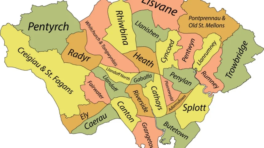
The 1999 structure included wards such as:
- Adamsdown
- Butetown
- Caerau
- Canton
- Cathays
- Cyncoed
- Ely
- Fairwater
- Gabalfa
- Grangetown
- Heath
- Llandaff
- Llanishen
- Llanrumney
- Pentwyn
- Penylan
- Plasnewydd
- Radyr
- Rhiwbina
- Riverside
- Rumney
- Splott
- Trowbridge
- Whitchurch and Tongwynlais
Other wards in the 29-ward system included Creigiau/St Fagans, Lisvane, Pentyrch, Pontprennau/Old St Mellons and Radyr, with the precise arrangements changing in 2022.
The 1999 system therefore became familiar to several generations of Cardiff residents.
It also created a long period of electoral stability. Although population and development patterns changed, the core 29-ward structure remained until the 2022 reforms.
Which Cardiff wards changed between 1999 and 2022?
The 2022 electoral review changed selected Cardiff wards rather than completely redrawing the city. Twenty-one existing wards were retained without boundary changes, while other areas received boundary, name or representation changes based on electoral equality and local geography.
The 2020 final recommendations from the Local Democracy and Boundary Commission for Wales identified specific areas requiring changes. The Commission published detailed maps and supporting documents for areas including Butetown, Grangetown, Lisvane and Thornhill, Llanishen, Llanrumney and Old St Mellons, Pentwyn, Pentyrch and St Fagans, Pontprennau and Radyr.
The review did not treat every Cardiff ward in the same way.
21 existing wards were retained without change under the reforms. These included Adamsdown, Caerau, Canton, Cathays, Cyncoed, Ely, Fairwater, Gabalfa, Heath, Llandaff, Llandaff North, Llanrumney, Penylan, Plasnewydd, Pontprennau and Old St Mellons, Rhiwbina, Riverside, Rumney, Splott, Trowbridge, and Whitchurch and Tongwynlais.
Other areas received revised arrangements.
The reforms also changed some ward names. For example, Pontprennau / Old St Mellons became Pontprennau and Old St Mellons.
These changes show that boundary reviews do not necessarily involve wholesale redrawing. Some wards remain intact while others are adjusted to respond to representation requirements.
Why were Cardiff’s ward boundaries reviewed in 2020 and 2021?
Cardiff’s electoral boundaries were reviewed to improve electoral equality and ensure that councillors represented broadly comparable numbers of electors. The review also considered identifiable boundaries, existing communities, local ties, rurality and other geographical factors.
Electoral boundaries require periodic review because populations change.
New housing developments increase elector numbers. Population movement changes the distribution of residents. Some established neighbourhoods grow faster than others.
The Democracy and Boundary Commission Cymru explains that electoral reviews seek to keep the ratio of electors to councillors roughly equal within each principal council. The process also considers identifiable boundaries and local community ties.
For Cardiff, the Commission published its Final Recommendations on 5 November 2020. The recommendations were then considered by the Welsh Government.
The Welsh Government accepted the majority of the recommendations but modified two specific arrangements.
One important modification concerned Llanrumney, Pontprennau and Old St Mellons. The Commission had recommended combining Llanrumney and Old St Mellons, but the Welsh Government retained the existing arrangements for Llanrumney and Pontprennau and Old St Mellons.
This illustrates the formal process. Boundary proposals are recommendations rather than automatically becoming law.
What changed in Cardiff’s ward boundaries in 2022?
The 2022 reforms reduced Cardiff from 29 to 28 electoral wards and increased representation from 75 to 79 councillors. All current wards are multi-member wards, with two, three or four councillors allocated according to the final electoral arrangements.
The new arrangements followed the City and County of Cardiff (Electoral Arrangements) Order 2021.
The Order came into force for most purposes on the ordinary day of election of councillors in 2022. It defines an electoral ward as an area from which members are elected to Cardiff Council.
The reform produced four important structural changes.
First, the number of wards fell from 29 to 28.
Second, the number of councillors increased from 75 to 79.
Third, all Cardiff wards became multi-member wards.
Fourth, the distribution of councillors became nine wards with two councillors, 15 wards with three councillors and four wards with four councillors.
The resulting structure was used for the May 2022 local government elections.
The reform therefore changed both where ward boundaries ran and how many councillors each ward elected.
Which current Cardiff wards are important when comparing old maps?
Current Cardiff wards include Adamsdown, Butetown, Caerau, Canton, Cathays, Creigiau/St Fagans, Cyncoed, Ely, Fairwater, Gabalfa, Grangetown, Heath, Lisvane and Thornhill, Llandaff, Llandaff North, Llanishen, Llanrumney, Pentwyn, Pentyrch and St Fagans, Penylan, Plasnewydd, Pontprennau and Old St Mellons, Radyr, Rhiwbina, Riverside, Rumney, Splott, Trowbridge, and Whitchurch and Tongwynlais, with the 2022 structure defining the official current arrangements.
Historical comparisons are easiest when the same place is tracked across different electoral systems.
For example, Lisvane was previously part of a combined Lisvane and St Mellons arrangement before becoming a separate ward from 1999. The 2022 review then created the current Lisvane and Thornhill arrangement.
Pentyrch also demonstrates the evolution of Cardiff’s boundaries. The older system had a Pentyrch ward. The 2022 structure introduced Pentyrch and St Fagans.
The western side of Cardiff also illustrates how community names and electoral names can differ across time.
Radyr was previously associated with St Fagans in the pre-1999 arrangements. From 1999, Radyr became a separate ward, while the later 2022 system altered nearby western Cardiff arrangements.
These examples show why a historic address search requires the correct electoral year.
How do ward boundaries differ from Cardiff’s parliamentary boundaries?
Cardiff’s council wards are not the same as UK parliamentary constituencies. Council wards elect Cardiff Council members, while parliamentary constituencies elect Members of Parliament. A parliamentary constituency can therefore contain several Cardiff wards and can cross the Cardiff local authority boundary.
This distinction is essential for electoral research.
The current UK parliamentary constituency structure uses different geographical units from Cardiff Council.
The Parliamentary Constituencies Order 2023 defines Cardiff East, Cardiff North, Cardiff South and Penarth, and Cardiff West using combinations of Cardiff wards and, in the case of Cardiff South and Penarth and Cardiff North, areas outside Cardiff.
For example, Cardiff East contains Adamsdown, Cyncoed, Llanrumney, Pentwyn, Penylan, Plasnewydd, Rumney and Trowbridge.
Cardiff North contains Gabalfa, Heath, Lisvane, Llandaff North, Llanishen, Pontprennau and Old St Mellons, Rhiwbina, and Whitchurch and Tongwynlais, alongside Taffs Well in Rhondda Cynon Taf.
This means a Cardiff resident can have one council ward, one UK parliamentary constituency and other electoral divisions that use different geographical boundaries.
How are Cardiff’s ward boundaries created and reviewed?
Cardiff’s electoral arrangements are established through a formal statutory process involving the Democracy and Boundary Commission Cymru and Welsh Ministers. Reviews assess electoral equality, ward boundaries, local ties and geography before recommendations are converted into legal electoral arrangements.
The Democracy and Boundary Commission Cymru is responsible for electoral reviews of Wales’s principal councils. It reviews electoral ward arrangements, including the number and boundaries of wards and the number of councillors assigned to each ward.
The process begins with an assessment of the existing arrangements.
The Commission then develops proposals and consults on them.
Representations from residents, councils and other interested parties are considered.
The Commission publishes final recommendations.
Welsh Ministers then decide whether to implement the recommendations, with or without modifications.
The final legal structure is established through an electoral arrangements order. For Cardiff, that legislation was the City and County of Cardiff (Electoral Arrangements) Order 2021.
The process is designed to balance numerical representation with geography and community identity.
The Commission’s stated considerations include the ratio of local government electors to elected members, identifiable ward boundaries and the desirability of preserving local ties.
Why do Cardiff’s ward boundaries matter today?
Cardiff’s ward boundaries determine local electoral representation and affect how residents identify their council representatives. They also influence the geographical units used for council election data, local statistics, community planning and analysis of Cardiff’s changing population.
Ward boundaries have practical importance beyond elections.
Cardiff Council uses electoral wards in different forms of local analysis. The council’s local wellbeing assessment, for example, includes indicator data for individual electoral wards.
The boundaries therefore influence how demographic, economic, environmental and social information is presented.
A ward can also become a useful geographical reference for local services and civic engagement.
However, ward boundaries should not automatically be treated as neighbourhood boundaries.
Neighbourhood identities often have longer histories than electoral arrangements. Cardiff places such as Roath, Splott, Grangetown, Canton and Cathays have cultural and geographical identities that do not depend solely on their current electoral boundaries.
The electoral map changes while local place identities can continue.
Explore More Area Guide
Weekend Heritage Walks Around Cardiff: Historic Routes & Sites
Discover Cardiff’s Old Villages: Llandaff, St Fagans and Radyr
How can you compare Cardiff’s old and current ward boundaries?
Comparing Cardiff’s historic and current wards requires matching each map to its election period and administrative system. The most useful sources are statutory electoral orders, boundary review reports, official maps, council records and historical geographic databases.
The first step is to identify the date.
A map from 1973 belongs to a different electoral structure from a map used in 1983.
A map from 1999 belongs to the 29-ward, 75-councillor structure.
A map from 2022 belongs to the current 28-ward, 79-councillor structure.
The second step is to identify the authority.
Older records can refer to Cardiff County Borough, Cardiff City Council, South Glamorgan County Council or the post-1996 City and County of Cardiff.
The third step is to use official boundary documents.
The Democracy and Boundary Commission Cymru’s Cardiff review archive provides final recommendations, existing-arrangement tables, recommended maps and supporting material.
Historical GIS resources also help researchers understand how Cardiff’s administrative boundaries changed through time. The University of Portsmouth’s A Vision of Britain through Time provides historical maps and administrative boundary information for Cardiff.
This approach avoids treating different electoral systems as if they were one continuous map.
What is the current significance of Cardiff’s ward boundaries?
Cardiff’s current ward boundaries reflect the city’s latest statutory electoral arrangements introduced for the 2022 local elections. The structure contains 28 wards and 79 councillors, replacing the previous 29-ward, 75-councillor system.
The history of Cardiff’s wards shows a continuing process of administrative adjustment.
The city moved from historic municipal wards to the 1973 Cardiff City Council structure. It then underwent changes in 1983, the 1995–1996 Welsh local government reorganisation, the 1999 electoral restructuring and the 2022 boundary reforms.
Each stage responded to a different administrative context.
The 2022 review is particularly significant because it changed the balance between ward numbers and council representation. Cardiff now has fewer wards than the 1999–2022 system but more councillors overall.
The current boundaries are therefore the result of a long administrative history rather than a single redesign.
Future changes will depend on subsequent statutory electoral reviews and decisions by the relevant Welsh authorities. The Democracy and Boundary Commission Cymru states that principal council electoral arrangements are reviewed periodically because elector numbers and settlement patterns change over time.
For residents, researchers and anyone studying Cardiff’s history, the key principle is simple: always match a ward name and boundary to the correct year. Cardiff’s electoral geography has changed repeatedly, and today’s ward map does not represent the city’s electoral geography throughout its history.
What are Cardiff’s electoral wards?
Cardiff’s electoral wards are geographical areas used to elect councillors to Cardiff Council. Each ward has defined boundaries and elects a set number of councillors.