Splott is a district and community in Cardiff, Wales, located east of Cardiff city centre between Roath, Adamsdown, Tremorfa and the former docklands. Its origins are much older than its dense Victorian streets. The name first appears in medieval records, while the landscape remained predominantly rural for centuries.
- Where does the name Splott come from?
- When was Splott first recorded in Cardiff?
- What was Splott like before Cardiff became industrial?
- How did Cardiff’s industrial expansion change Splott?
- When did Splott become a densely built-up suburb?
- Why were terraced houses important to the origins of Splott?
- How did the East Moors steelworks affect the origins of Splott?
- What role did transport play in Splott’s development?
- How did Splott develop its community institutions?
- Did Splott have connections with aviation?
- How did Splott change after the decline of heavy industry?
- What does the history of Splott reveal about Cardiff?
- Why are the origins of Splott still relevant?
The modern identity of Splott developed during Cardiff’s rapid industrial expansion in the nineteenth century. Agricultural land associated with Upper Splott Farm and Lower Splott Farm was transformed into housing, streets, schools, chapels, commercial premises and industrial facilities. The nearby Cardiff Docks and East Moors steelworks became major influences on the area’s economic and social development.
Understanding the origins of Splott therefore requires more than examining its name. The history involves medieval landholding, coastal marshland, farming, estate ownership, industrialisation, railway development, housing expansion and the creation of a working-class urban community.
Where does the name Splott come from?
The name Splott is an old place-name with medieval documentary evidence, but its precise linguistic origin remains unresolved. Historical sources record forms including Splot, Splattye, the Splote and Splott, while local historians associate it with a plot of reclaimed or enclosed land.
The origin of the word “Splott” has attracted considerable discussion among Cardiff historians. The earliest forms of the name demonstrate that it is centuries older than the modern suburb.
Research published by the Roath Local History Society records several historical forms: Splot in 1393, Splot in 1540, Splattye in 1568, the Splote in 1586, Splott in 1604, the Splott in 1615 and the Splott in 1658. These spellings show that the name developed gradually rather than appearing suddenly with Victorian urbanisation.
One established interpretation connects the name with an old English term describing a plot or patch of land. Similar place-names occur in parts of southern Wales and western England. The linguistic evidence therefore places the name within a wider pattern of English-derived agricultural place-names.
Another explanation links Splott with land reclaimed from coastal marshes. Local historical accounts describe settlers enclosing and draining salt-marsh land and dividing it into plots. This interpretation connects the name directly with the physical geography of Cardiff’s eastern coastal plain.
The popular explanation that Splott is a shortened form of “God’s Plot” is less secure. The story relates to medieval ecclesiastical ownership and the Bishop of Llandaff, but historical discussion does not establish it as the definitive linguistic source.
A further theory associates Splott with the Welsh word ysblad, traditionally interpreted as firm land surrounded by marsh. Local sources have repeated this explanation, but modern historical discussion continues to favour an old English place-name explanation rather than treating the theory as proven.
The important point is that Splott existed as a named locality long before it became a densely built Cardiff suburb. Its name belongs to the medieval agricultural landscape rather than the later industrial city.
When was Splott first recorded in Cardiff?
Splott has medieval documentary origins, with historical research identifying a written reference from the fifteenth century and earlier forms appearing in place-name records. The locality was associated with agricultural land, farms and estate ownership centuries before Cardiff’s Victorian urban expansion.
A 2025 local-history project states that the first reference to Splott dates to 1440, when records associated the land with Isabel le Despenser, Countess of Worcester and Warwick. Local historical research also identifies earlier forms of the place-name, including “Splot” in 1393.
These records place Splott firmly within Cardiff’s medieval landscape. At this stage, Splott was not a residential suburb. It was rural land situated between Roath and the coastal area around the River Rhymney.
The land passed through different ownership arrangements over the centuries. Historical research identifies the Bawdrip family as important landowners. The family names appear in several forms, including de Baggetrippe, Baudrub, Bawdryp and Bawdrip. Their association with Splott lasted for centuries.
John Leland, the sixteenth-century English antiquarian and traveller, recorded Splott as a place associated with the Bawdrip family. His description places the settlement near the mouth of the River Rhymney and the coast.
This geographical position explains much about Splott’s later development. The district occupied low-lying land near Cardiff’s eastern waterways and coastal marshes. Its early importance came from land ownership and agriculture rather than urban commerce.
Medieval Splott therefore represents a different landscape from the one visible today. There were no continuous terraces, industrial streets or dense commercial corridors. Farms and open land dominated the locality.
What was Splott like before Cardiff became industrial?
Before industrialisation, Splott was predominantly agricultural land on Cardiff’s low-lying eastern side. Upper and Lower Splott Farms operated across the area, while nearby marshes, moorland and coastal land shaped farming, drainage and settlement patterns before Victorian housing transformed the landscape.
For much of its early history, Splott was rural. Historical accounts identify Upper Splott Farm and Lower Splott Farm as the principal agricultural units associated with the district.
The surrounding landscape contained marshy and tidal areas. The eastern side of Cardiff was strongly influenced by the River Rhymney and the coastal plain. Land drainage and reclamation were therefore important to the development of usable agricultural ground.
Local historical research describes the reclamation of salt-marsh land through sea walls, drainage and enclosure. These processes converted wet coastal areas into fields suitable for agricultural use.
Splott was also connected to neighbouring rural settlements. Roath, Tremorfa and Pengam formed parts of a wider agricultural landscape before the nineteenth-century expansion of Cardiff.
The area’s rural character survived surprisingly late. Even during the nineteenth century, maps and census records continued to record farms and farm-related buildings alongside the rapidly expanding city.
The 1871 Census is particularly useful because it recorded “Splottlands” rather than simply the modern urban district name. It included Splottland Farm, Splottland Farm Cottages and Splottlands Terrace. This evidence demonstrates the transitional character of the area during the early stages of urbanisation.
Splott therefore developed from agricultural land into an urban district rather than beginning as a planned industrial suburb. The industrial city arrived around an existing rural landscape.
How did Cardiff’s industrial expansion change Splott?
Cardiff’s nineteenth-century industrial expansion transformed Splott from farmland into an urban district. Coal exports, dock development, railways and nearby metal production created employment, increased population and generated demand for dense housing close to industrial workplaces.
The transformation of Splott was closely connected with Cardiff’s emergence as a major industrial port.
Cardiff’s industrial growth accelerated during the nineteenth century as coal from the South Wales Valleys moved toward the docks. The Glamorganshire Canal opened in 1794, linking Cardiff with Merthyr Tydfil. A canal basin followed in 1798. The Taff Vale Railway opened in 1841, strengthening Cardiff’s industrial transport network.
Cardiff’s docks expanded as coal exports increased. Roath Dock opened in 1887, followed by the Queen Alexandra Dock in 1907. Cardiff became an international coal-exporting centre, with more than 10 million tons passing through the port in 1913.
This industrial growth changed the value of land around Splott. Agricultural fields were increasingly positioned beside transport infrastructure, docks, warehouses, factories and industrial employment.
The district became attractive for housing because workers needed homes within practical travelling distance of their workplaces. The development of terraced housing responded directly to this demographic and economic pressure.
Splott’s location east of Cardiff city centre also gave it strategic importance. It stood close to the docks and East Moors industrial area while remaining connected to the wider urban transport system.
The industrial transformation therefore changed both the physical landscape and the social structure of Splott.
When did Splott become a densely built-up suburb?
Splott became a densely developed suburb mainly during the late nineteenth century, when estate development replaced farmland with terraced housing, roads, schools, churches, chapels, shops and public facilities serving a rapidly growing working-class population.
Urban development accelerated particularly during the 1880s and 1890s. The Tredegar Estate played a central role in developing its land holdings for residential purposes.
The Catholic heritage organisation Taking Stock describes Splott as an area developed by the Tredegar Estate during the 1880s and 1890s. The new district contained artisan housing with broad streets and stone terraces.
The development was systematic. Streets were laid out across former agricultural land. Houses were built in rows. Religious organisations established churches and chapels. Schools and community institutions followed the growing population.
Cardiff Council’s Local Development Plan records that Railway Street was constructed between 1881 and 1899 as part of Splott’s development. A new Cardiff Arms hotel was reported in 1886 in the district then described as Splotlands.
Population growth was rapid. Cardiff Council’s heritage research records that newspapers reported a Splott population of 10,183 in 1893, describing the increase as “almost abnormal”. The same report described local public houses as heavily crowded.
This population increase demonstrates the scale of change. Within a relatively short period, farmland became a densely populated urban neighbourhood.
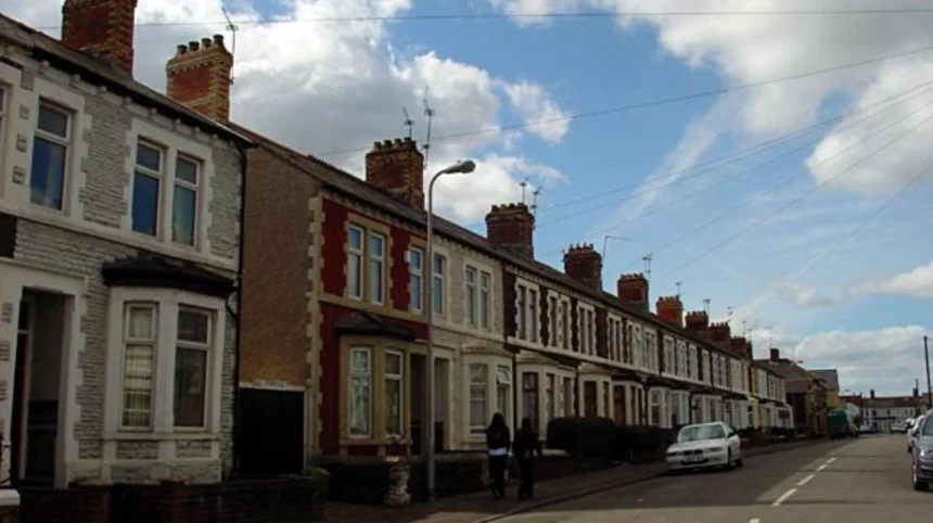
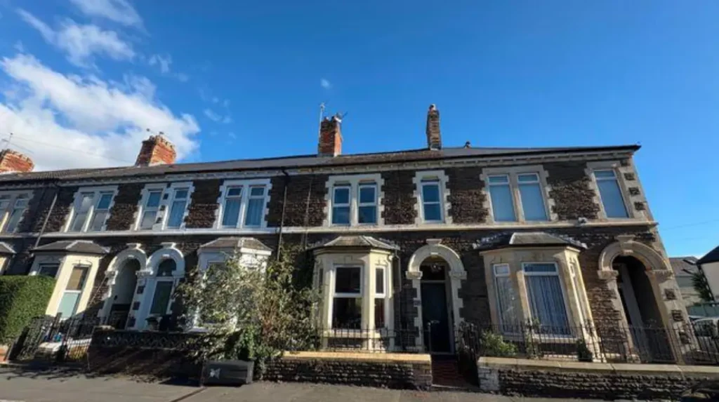
The architecture of modern Splott retains substantial evidence of this period. Terraced houses, narrow residential streets, former public houses, religious buildings and surviving industrial structures reflect the district’s Victorian and Edwardian development.
Why were terraced houses important to the origins of Splott?
Terraced housing provided dense accommodation for Cardiff’s expanding industrial workforce. In Splott, residential streets developed alongside factories, docks and transport infrastructure, creating a compact working-class district where housing, employment, schools, worship and local commerce operated within close proximity.
Terraced housing was a defining component of industrial Cardiff. Splott’s residential development followed the same wider urban pattern.
Builders constructed repeated rows of houses because the format allowed substantial numbers of workers and families to live on relatively limited urban land. The arrangement also supported streets, shops, schools and community facilities.
The housing was closely connected with employment. The nearby East Moors industrial complex became one of the most significant employers affecting the district.
The social infrastructure expanded alongside housing. Churches and chapels appeared during the late nineteenth century. Splott Road Baptist Sunday School was built in 1884, while its chapel was constructed in 1895.
Bethlehem Independent Chapel was also built in 1895 and rebuilt in 1908.
Catholic provision developed during the same period. A large Catholic school-chapel on Swinton Street opened in June 1891, serving the newly developed community.
These buildings demonstrate that Splott’s origins as an urban community involved more than houses. The district developed a complete social structure around a growing population.
Schools, churches, chapels, public houses, shops, sports facilities and workplaces all contributed to the formation of a recognisable neighbourhood.
How did the East Moors steelworks affect the origins of Splott?
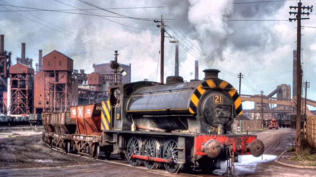
The East Moors steelworks became one of the most important industrial influences on Splott. Built from 1890, the works connected the district to Cardiff Docks, imported iron ore, railway transport and large-scale steel production, reinforcing Splott’s industrial working-class identity.
The East Moors steelworks fundamentally altered the eastern side of Cardiff.
Coflein, the historic environment record maintained by the Royal Commission on the Ancient and Historical Monuments of Wales, records that Guest, Keen and Nettlefolds moved major production from Merthyr Tydfil to Cardiff by building a new steelworks at East Moors in 1890. The location provided more convenient access to Cardiff Docks.
Museum Wales records that the Dowlais-Cardiff Steel Works was built in stages between 1891 and 1895 on previously undeveloped pasture known as Cardiff East Moors. It stood close to Cardiff Docks, where iron ore could be imported.
The works eventually became known as the East Moors Works after the Second World War. They remained an important industrial site until closure in 1978.
The steelworks influenced employment, housing and local commerce. Workers needed accommodation, transport and services. Public houses and shops developed around the expanding population.
The relationship between housing and industrial employment is visible in surviving local heritage. Cardiff Council records that the former Grosvenor Hotel, opened in 1893, became associated with steelworkers travelling home after shifts.
The East Moors works therefore formed a major part of the economic environment that shaped modern Splott.
What role did transport play in Splott’s development?
Transport accelerated Splott’s transformation by connecting its housing and industries with Cardiff Docks, the wider railway network and industrial South Wales. Roads, railway infrastructure and dock facilities supported the movement of workers, raw materials and finished industrial products.
Transport was essential to Cardiff’s industrial economy.
The city’s canal and railway systems connected industrial production in the South Wales Valleys with Cardiff’s docks. The Taff Vale Railway, opened in 1841, was particularly important to Cardiff’s development as a coal-exporting port.
Splott benefited from this wider network because it was positioned close to the eastern industrial corridor.
Railway Street is direct evidence of the relationship between transport and urbanisation. Its construction between 1881 and 1899 occurred during the period when Splott was rapidly changing from farmland into a residential district.
Transport also supported industrial supply chains. The East Moors steelworks relied on proximity to Cardiff Docks for imported iron ore. This reduced the distance between maritime transport and industrial production.
The result was a connected industrial landscape. Docks supplied materials. Railways transported goods. Factories provided employment. Housing accommodated workers. Local businesses supplied everyday needs.
Splott’s urban form therefore developed within Cardiff’s wider transport geography rather than independently from it.
How did Splott develop its community institutions?
Splott developed community institutions alongside its Victorian housing, including churches, chapels, schools, sports facilities and public houses. These institutions provided education, worship, recreation, social organisation and everyday services for the rapidly expanding residential population.
The development of community institutions shows how quickly Splott evolved into an established urban neighbourhood.
Religious buildings appeared in several denominations. Splott Road Baptist Chapel, Bethlehem Independent Chapel and St Alban-on-the-Moors demonstrate the religious diversity of the developing community.
Education also expanded. Schools were established alongside housing development to serve children in the growing district.
Public recreation became another important element. Splott Park was gifted by Lord Tredegar to Cardiff Corporation in December 1901. The Edwardian park covered 18 acres. A bandstand was built in 1904, while cricket pitches and a children’s playground were also laid out in 1904.
The park later received additional facilities. Practice nets appeared in 1905, a bowling green opened in 1906 and tennis courts were provided in 1907. A swimming pool opened on 14 August 1922.
These developments demonstrate that Splott’s identity extended beyond industrial employment. The district acquired the institutions required for a long-term community.
The emergence of parks, sports facilities, religious buildings and schools also indicates the permanence of the settlement. Splott was no longer temporary worker accommodation around factories. It had become an established Cardiff neighbourhood.
Did Splott have connections with aviation?
Splott and the neighbouring East Moors and Pengam areas became associated with early aviation during the twentieth century. A civilian aerodrome opened at Pengam Moor in 1931, later becoming Cardiff Municipal Airport before aviation operations transferred elsewhere.
Aviation became another chapter in the district’s industrial and technological history.
Coflein records that the airfield at Pengam Moor opened as a civilian aerodrome in September 1931. It was initially called Splott and became known as Cardiff Municipal Airport by 1936.
Scheduled commercial services began in 1932, including a Bristol–Cardiff service operated by British Air Navigation Company. Great Western Railway Air Service began flights in 1933.
The site also acquired military significance. During the Second World War, the airfield was used for military purposes and later for bomb storage. Civilian operations resumed after the war.
Civil flying eventually transferred from Pengam Moor on 1 April 1954. The site later became associated with other aviation uses before the development of modern Cardiff Airport at Rhoose.
The aviation history reinforces a wider point about Splott. The district’s history was shaped repeatedly by Cardiff’s changing transport and industrial economy.
How did Splott change after the decline of heavy industry?
Splott changed significantly after the decline of heavy industry, particularly following the closure of East Moors Works in 1978. Industrial land was demolished, reused or redeveloped, while Splott retained its residential streets and community identity.
The closure of East Moors Works marked a major break in Splott’s industrial history.
The steelworks had operated for decades and had influenced employment, housing and local commerce. When the works closed in 1978, the large industrial landscape entered a new phase.
Industrial decline affected communities across South Wales. Splott retained its Victorian and Edwardian residential fabric even as some of the industrial employment that had shaped the area disappeared.
Former industrial land was gradually cleared and redeveloped. Some sites became commercial or industrial units, while other areas were incorporated into modern regeneration and employment spaces.
Cardiff Council continues to identify Splott Workshops on Portmanmoor Road among its managed workshop and business starter-unit locations. The council states that its workshop programme includes units intended to support new and expanding businesses.
This demonstrates the changing economic role of the district. Heavy steel production has disappeared, but employment and commercial activity remain part of Splott’s modern landscape.
The physical remnants of industrial history also remain important to understanding the district. Museum Wales preserves photographs, documents and industrial objects associated with East Moors Works, including material recovered from its former site.
Explore More Area Guide
Why Is Rumney Called Rumney? History of the Name Cardiff 2026
Cardiff Bus Pass Guide: Eligibility & Free Travel 2026
What does the history of Splott reveal about Cardiff?
The origins of Splott demonstrate how Cardiff evolved from rural and coastal land into an industrial city. Medieval landholding became farmland, farmland became housing, and housing developed alongside docks, railways, steelworks, schools, parks and community institutions.
Splott provides a concentrated example of Cardiff’s wider urban transformation.
The district began as named agricultural land associated with farms and estates. Its low-lying geography influenced farming and land reclamation. Cardiff’s industrial expansion then increased the economic value of land east of the city centre.
The growth of Cardiff Docks created demand for transport, labour and industrial facilities. East Moors became a major steelmaking location because of its proximity to maritime infrastructure.
Housing development followed employment. By the 1890s, Splott had become a densely populated district with more than 10,000 residents, according to contemporary reporting cited by Cardiff Council’s heritage research.
Community institutions established permanence. Chapels, churches, schools, public houses and parks provided the infrastructure of everyday urban life.
The twentieth century added further layers, including aviation, expanding commercial activity and later industrial decline. The closure of East Moors Works in 1978 represented the end of an important industrial era, but not the end of Splott as a community.
Today, Splott’s historical importance rests in this layered development. Its name predates the modern city. Its streets reflect Victorian urbanisation. Its industrial history connects directly to Cardiff Docks and South Wales steelmaking. Its surviving institutions preserve evidence of the community created during Cardiff’s industrial expansion.
The origins of Splott are therefore best understood as a long process rather than a single founding event. Medieval land, agricultural farms, estate development, industrialisation and community formation each contributed to the district that exists in Cardiff today.
Why are the origins of Splott still relevant?
The history of Splott remains relevant because its physical environment preserves evidence of several major stages of Cardiff’s development. The historic street pattern, terraces, religious buildings, parkland and former industrial sites connect present-day Cardiff with its medieval and industrial past.
Modern planning and heritage research continue to recognise the importance of this layered history. Cardiff Council’s heritage documentation identifies historic buildings and former public houses within Splott, while Coflein records archaeological and architectural sites across the community.
The district also demonstrates the relationship between geography and economic development. Its position near Cardiff Docks helped attract industry. Its proximity to industrial workplaces encouraged housing development. Its transport connections supported both employment and population growth.
The story of Splott also illustrates the importance of preserving local records. Historical maps, census returns, photographs, architectural surveys, museum collections and community research collectively reveal how the district changed.
For residents and visitors studying Cardiff history, Splott provides a clear case study of urbanisation in South Wales. The district links medieval place-name history with the industrial transformation that made Cardiff a major port and city.
Its origins are consequently part of the wider history of Cardiff, Glamorgan, South Wales industrialisation and the development of modern Welsh urban communities.
Where does the name Splott come from?
The name Splott has medieval origins. Historical records contain forms such as “Splot” in 1393, “Splattye” in 1568 and “Splott” in 1604. Its precise linguistic origin remains debated, with interpretations connecting it to a plot or patch of land.