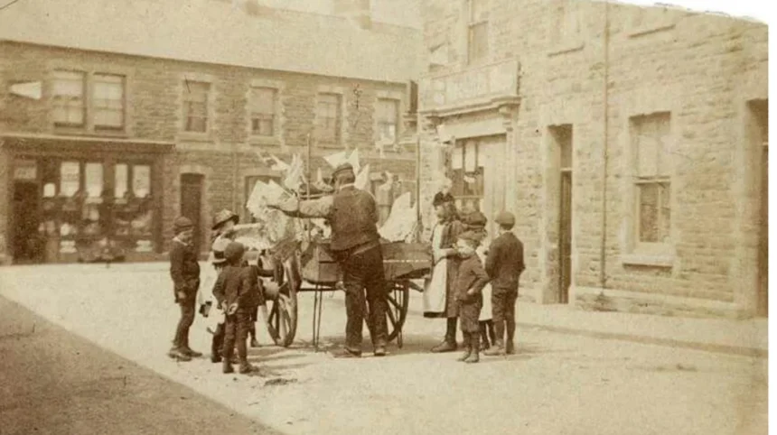
Splott is an established residential district in eastern Cardiff, Wales, with a history shaped by industrial expansion, railway development, steel production, working-class housing and community life. Its transformation reflects Cardiff’s growth from a port city into a major urban centre and the changing fortunes of South Wales industry.
- What is Splott, Cardiff, and where is it located?
- What was Splott like before industrialisation?
- How did the Industrial Revolution transform Splott?
- When was Splott developed into a residential neighbourhood?
- Why was East Moors Steelworks important to Splott’s history?
- How did Cardiff’s docks and railways influence Splott?
- What role did parks and public spaces play in Splott’s development?
- How did community life develop in historic Splott?
- How did the twentieth century change Splott?
- What happened to Splott after the decline of heavy industry?
- What historic buildings and records reveal Splott’s past?
- How does Splott’s history compare with other Cardiff neighbourhoods?
- How can visitors explore the history of Splott today?
- Why does Splott’s industrial heritage matter today?
- What is the future significance of Splott’s history?
- How did Splott become the Cardiff neighbourhood it is today?
Understanding the history of Splott means examining its rural origins, its development during the Industrial Revolution, its relationship with Cardiff’s docks and steelworks, and the changes that reshaped the neighbourhood during the twentieth and twenty-first centuries. Streets, former industrial sites, public buildings and local community institutions provide important evidence of this development.
What is Splott, Cardiff, and where is it located?
Splott is a residential district in eastern Cardiff, the capital of Wales. It developed substantially during the nineteenth and early twentieth centuries as Cardiff expanded through coal exports, steel production, railway construction and industrial employment. Its historic identity remains closely connected to working-class housing and community life.
Splott lies east of Cardiff city centre, within the wider urban area of South Wales. The neighbourhood developed alongside other eastern Cardiff districts, including Adamsdown and Tremorfa, as industrial employment and population growth increased demand for housing.
Cardiff is a city in South Wales that grew rapidly during the nineteenth century because of its position near the South Wales coalfield. Its docks connected coal-producing communities with international markets, while railways carried coal, iron and manufactured goods towards the coast.
Splott formed part of this expanding urban landscape. Its residential streets accommodated workers and families connected with Cardiff’s industrial economy. Over time, the district developed schools, shops, places of worship, recreation facilities and community organisations that supported everyday life.
The name Splott is commonly associated with the Welsh word ysblot, meaning a plot or small piece of land, although the precise historical development of the place name requires careful interpretation of early records. The name reflects the area’s earlier landscape, before dense housing replaced much of its rural character.
Today, Splott combines historic terraced streets, later housing, former industrial land and modern redevelopment. Its built environment preserves evidence of Cardiff’s industrial expansion and the long-term changes affecting urban communities across South Wales.
What was Splott like before industrialisation?
Before Cardiff’s industrial expansion, Splott formed part of a less densely developed landscape on the eastern side of the settlement. Agricultural land, scattered properties and local routes characterised the wider area before industrial employment encouraged substantial population growth and urban housing construction.
Cardiff’s early history centred on its castle, settlement and access to the Bristol Channel. For centuries, the surrounding countryside supported farming, local trade and small settlements rather than the dense residential districts that emerged during the industrial period.
Splott’s earlier landscape belonged to this wider rural setting. Land use changed gradually as Cardiff became increasingly connected to regional trade and transport. The expansion of roads, railways and industrial sites eventually altered the relationship between the countryside and the growing town.
Historical research into early Splott benefits from distinguishing between the documented history of Cardiff and the more specific evidence for individual fields, farms and properties. Parish records, historic maps, land documents and census returns help establish when particular areas became occupied and how their uses changed.
The absence of large industrial facilities in the earliest period does not mean the area was disconnected from Cardiff’s economy. Agricultural production, local transport and land ownership formed part of the economic system that preceded intensive urban development.
As the nineteenth century progressed, the value of land around Cardiff changed. Industrial employers required accessible sites, while workers needed homes within reasonable travelling distance of factories, docks and railway facilities. Splott’s location made it increasingly suitable for residential expansion.
How did the Industrial Revolution transform Splott?
The Industrial Revolution transformed Splott through Cardiff’s expanding demand for workers, transport infrastructure and housing. During the nineteenth century, coal exports, iron and steel production, and railway development encouraged urban growth. Splott increasingly became a residential district serving the wider industrial economy.
The Industrial Revolution was a period of economic and technological change that expanded factory production, mineral extraction, mechanised transport and urban employment. In South Wales, coal mining and metal production became major forces behind industrialisation.
Cardiff’s port grew in importance as coal from the South Wales valleys reached domestic and international markets. The construction and expansion of dock facilities increased the city’s capacity to handle exports, while railway networks linked industrial centres with the coast.
Splott benefited indirectly but significantly from this expansion. Industrial workers needed housing, shops and public services, and residential development spread beyond Cardiff’s older urban core. Land that had previously supported rural activities became increasingly valuable for building.
The area’s growth was part of a wider regional pattern. Communities across Cardiff and the South Wales valleys expanded as employers attracted workers from nearby counties and more distant parts of Britain. Population growth placed pressure on housing, sanitation, roads and public services.
Industrialisation also changed social relationships. Wage employment became central to household income, while shift work and factory schedules shaped daily routines. Neighbourhoods such as Splott developed close connections between housing, employment, family networks and local institutions.
The process was not instantaneous. Urban growth occurred in stages, influenced by industrial investment, transport connections, land development and economic conditions. These changes established the foundations of Splott’s later identity as a densely settled working-class district.
When was Splott developed into a residential neighbourhood?
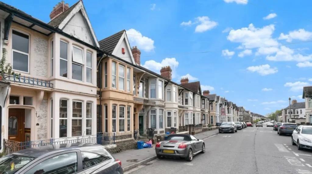
Splott developed rapidly during the late nineteenth century, particularly between approximately 1875 and 1914. Housing construction accommodated workers employed in Cardiff’s expanding industrial sector. Terraced houses, local shops, religious buildings and public facilities established the district’s recognisable urban character.
The growth of Splott followed the wider expansion of Cardiff. As the city’s industrial workforce increased, developers built rows of houses on land near factories, railway lines and dock-related employment.
According to local historical accounts published by Inksplott, much of Splott’s housing dates from 1875 to 1914. Streets including Splott Road, Portmanmoor Road and Moorland Road formed important parts of the developing neighbourhood. These streets helped connect residential areas with shops, workplaces and local services.
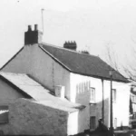
Terraced housing became a defining feature of the district. A terrace consists of adjoining houses built in a continuous row, often sharing side walls. This arrangement allowed developers to accommodate many households within a limited area close to industrial employment.
The buildings reflected practical economic requirements. Small urban homes provided accommodation for industrial workers and their families, while nearby shops supplied food, household goods and everyday services. Local businesses also created employment outside factories and steelworks.
Historical maps help identify the pace of this transformation. Ordnance Survey maps from 1897, 1899–1900, 1916 and later decades show how the built environment changed over time. Comparing successive editions reveals the expansion of streets, housing blocks, railway infrastructure and industrial sites. Francis Frith+1
Why was East Moors Steelworks important to Splott’s history?
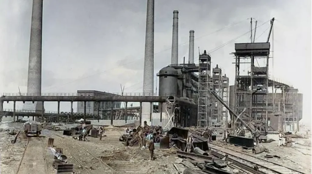
East Moors Steelworks was one of the most important industrial sites associated with Splott. Built near Cardiff Docks in 1890 and opened in February 1891, it supported regional steel production and employment until its closure in 1978, when industrial restructuring transformed eastern Cardiff.
East Moors Steelworks was established by Guest, Keen and Nettlefolds, a company connected with the Dowlais ironmaking industry in Merthyr Tydfil. The company selected a site near Cardiff Docks to benefit from convenient access to sea transport.
The works opened in 1891 and became known as Dowlais Steelworks. Its location connected industrial production with the port facilities that handled materials and goods. The steelworks formed part of the wider industrial network linking South Wales’s mineral resources, manufacturing centres and international trade.
Steel production involved several stages, including processing raw materials, producing metal and manufacturing steel products for industrial use. East Moors contributed to the regional metalworking economy and produced steel products associated with engineering and shipbuilding.
The steelworks also influenced the surrounding community. Industrial employment supported households, local shops and service businesses. The concentration of jobs helped sustain demand for nearby housing, reinforcing Splott’s role as an established working-class neighbourhood.
The facility remained an important industrial presence through much of the twentieth century. Its operations continued during periods of economic change, including the Second World War. Local historical accounts report that the site survived an air raid in 1944.
East Moors Steelworks closed in 1978. The closure marked a major turning point for the area because the site had connected Splott with Cardiff’s industrial economy for generations. The former works was subsequently demolished and the land partly redeveloped.
The Royal Commission on the Ancient and Historical Monuments of Wales records the steelworks in its Coflein historic-environment database. This record documents its location, industrial significance and eventual closure.
How did Cardiff’s docks and railways influence Splott?
Cardiff’s docks and railways shaped Splott by connecting eastern Cardiff with industrial production, employment and international trade. Railways moved coal and manufactured goods, while the docks enabled maritime transport. These networks encouraged industrial investment and supported the expansion of nearby residential districts.
Cardiff’s docks developed to serve the growing coal trade of South Wales. Coal from the valleys travelled by rail to the coast, where ships carried it to markets in Britain and overseas.
Railway infrastructure supported this system by connecting collieries, industrial works, freight facilities and port installations. The transport network helped Cardiff become one of Britain’s major coal-exporting ports during the nineteenth and early twentieth centuries.
Splott was positioned within this industrial landscape. Its proximity to East Moors and the wider eastern Cardiff transport network made it part of the city’s industrial geography. Workers living in the neighbourhood could access employment connected with manufacturing, transport, maintenance and port activity.
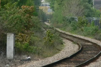
Railways also influenced the physical layout of the area. Tracks, sidings and industrial access routes occupied land and shaped the development of nearby streets. Historic maps provide evidence of these connections and help researchers understand how infrastructure affected urban growth.
The relationship between transport and housing extended beyond Splott. Other Cardiff neighbourhoods expanded as the city’s economic activity spread outward from the centre and docks. The development of residential streets therefore reflected a wider process of industrial urbanisation rather than an isolated local event.
Cardiff’s docks later changed as the coal trade declined and shipping requirements evolved. These changes affected employment patterns across the city, including communities that had depended on industrial and transport-related work.
What role did parks and public spaces play in Splott’s development?
Parks and public spaces became important as Splott grew into a densely populated residential district. They provided opportunities for recreation, exercise and community activities outside the home. Their development reflected wider efforts to improve urban living conditions in expanding industrial cities.
Rapid industrial growth created challenges for nineteenth-century towns and cities. Densely built housing increased the importance of accessible outdoor spaces, particularly in neighbourhoods where many households occupied relatively small homes.
Public parks offered space for walking, informal games, organised sport and social gatherings. They also created shared environments for residents of different ages and backgrounds.
Local historical accounts connect the development of parks in Splott with land donated by Lord Tredegar, a member of the Morgan family whose estates covered extensive areas of South Wales. These green spaces formed part of the broader development of public amenities alongside housing and commercial streets. Inksplott
The significance of parks extended beyond recreation. Public spaces supported community identity and provided settings for local events. Their continued use also demonstrates how neighbourhood infrastructure can outlast the economic conditions that originally shaped an area.
Parks remain relevant to Splott’s urban environment because they provide open space within a built-up district. They contribute to everyday exercise, children’s play and informal social contact.
When researching individual parks, historical maps, council records and local heritage publications help establish their opening dates, original purposes and later alterations. This approach distinguishes documented local history from general assumptions about the development of public parks.
How did community life develop in historic Splott?
Community life in Splott grew alongside its housing and industrial workforce. Residents established local networks through family relationships, schools, religious institutions, shops and recreation. These organisations supported everyday needs and helped create a distinct neighbourhood identity within the expanding city of Cardiff.
Industrial neighbourhoods depended on more than factories and housing. Families needed education, places of worship, food shops, healthcare and opportunities for social interaction. As Splott expanded, local institutions became important parts of its social infrastructure.
Schools provided education for children living in the district. Religious buildings served congregations and frequently supported charitable work, social gatherings and community activities. Independent shops supplied household essentials and created meeting points within residential streets.
Local businesses also helped connect the industrial economy with domestic life. Grocers, public houses, tradespeople and other retailers served households whose income often depended on industrial employment. Their activities helped maintain neighbourhood commerce and supported local employment.
The history of Splott Road Baptist Church provides a specific example of the district’s religious heritage. Cardiff’s archival records include church programmes, orders of service and other material relating to the church between 1911 and 2002. The records also document later redevelopment of the church site.
Community organisations became particularly important during periods of economic uncertainty. When industrial employment declined, residents faced changes to household income, local businesses and established social networks. Community groups helped preserve local connections and maintain activities independent of major employers.
The social history of Splott therefore includes both formal institutions and everyday neighbourhood relationships. Census records, school documents, church archives, newspapers and oral histories provide different forms of evidence about how residents lived and how the district changed over time.
How did the twentieth century change Splott?
During the twentieth century, Splott experienced industrial expansion, wartime disruption, changing employment patterns and the gradual decline of traditional heavy industry. The closure of East Moors Steelworks in 1978 accelerated the transition from an industrially connected neighbourhood towards a more diverse residential and urban environment.
The early twentieth century continued the period of substantial urban development. Housing and community institutions established during the late Victorian and Edwardian periods formed the foundations of the neighbourhood’s built environment.
The two world wars affected Cardiff’s industrial and residential areas. Industrial facilities remained important to national production, while Cardiff’s docks and manufacturing sites formed part of Britain’s wartime economy. The industrial landscape also exposed the city to the risks associated with attacks on strategic infrastructure.
The steelworks at East Moors continued operating through much of this period. Its production contributed to the regional economy, while its workforce supported local households and businesses.
After the Second World War, British industry underwent significant changes. Technological developments, international competition, shifts in demand and industrial restructuring altered the prospects of traditional manufacturing centres.
For Splott, the closure of East Moors Steelworks in 1978 was a defining event. The loss of a major industrial employer affected the wider eastern Cardiff area, where industrial jobs had helped sustain housing demand and local commerce.
The physical landscape changed as industrial buildings were removed and former industrial land became available for other uses. This process altered the relationship between the neighbourhood and the large-scale industrial facilities that had influenced its development.
The twentieth-century history of Splott demonstrates how a residential community adapts when its economic foundations change. Its streets and housing continued to serve residents even as the surrounding employment landscape became less dependent on heavy industry.
What happened to Splott after the decline of heavy industry?
After the decline of heavy industry, Splott experienced changes in employment, land use and the local economy. Former industrial sites were demolished or redeveloped, while housing and community services remained central to neighbourhood life. The district became increasingly connected with Cardiff’s wider service-based economy.
The closure of major industrial facilities changed the economic geography of eastern Cardiff. Land previously occupied by steelmaking infrastructure no longer served the same production functions, creating opportunities for redevelopment.
Redevelopment involves changing the use or physical arrangement of land and buildings. Former industrial areas can accommodate commercial premises, transport infrastructure, housing, public facilities or other urban uses, depending on planning decisions and environmental conditions.
The transformation of East Moors illustrates this process. Coflein records that the former steelworks was demolished and its site partly redeveloped after closure. The change represents a shift from large-scale metal production towards a different pattern of urban land use.
The wider transition also affected the relationship between home and work. Residents increasingly relied on employment across Cardiff rather than on a single major local industrial site. Transport connections remained important because they linked the neighbourhood with employment, education and services elsewhere in the city.
Residential streets continued to provide the framework for local life. Historic terraces remained visible reminders of the industrial period, even where nearby land had changed substantially.
Post-industrial redevelopment also raised questions about environmental conditions. Former industrial land requires appropriate assessment before new uses begin, particularly where past operations involved metal production, fuel storage or other potentially contaminating activities.
The history of this transition helps explain the mixed character of modern Splott. Its residential heritage remains evident, while changes to surrounding land reflect Cardiff’s continuing economic and physical development.
What historic buildings and records reveal Splott’s past?
Historic buildings, maps, census returns and archival documents provide evidence of Splott’s transformation from agricultural land into an industrial residential district. These sources help researchers establish when streets appeared, identify former land uses and trace the development of homes, businesses and community institutions.
Splott’s history is documented through a combination of physical evidence and written records. Historic maps are particularly useful because they show the changing arrangement of buildings, streets, railway lines and industrial sites.
Ordnance Survey maps provide detailed snapshots of the area at different dates. Maps from the late nineteenth century and early twentieth century help researchers compare the growth of housing with the development of nearby industrial infrastructure.
Glamorgan Archives preserves historical material relating to Cardiff and the surrounding region. Its resources include maps, building plans, photographs, trade directories and census-related records. These collections help establish the dates and circumstances of local development.
Census returns offer another important source. The national census records households and population characteristics at regular intervals. The surviving individual census returns from 1841 onwards allow researchers to investigate occupation, age, household structure and place of birth, although some records are incomplete or difficult to identify precisely.
The Roath Local History Society has published research on Splott’s early landholding and settlement. Its account records references to Splott Farm in the 1853 voters’ list and identifies a farm household in the 1871 census. It also documents early references to Splottlands Terrace. Roath Local History Society
These details provide evidence of the transition from rural landholding towards residential development. They also demonstrate why local history requires more than a single source: maps establish physical layouts, census returns describe households, and directories document people and businesses.
Researchers can compare these records to investigate individual streets, family histories and changes in land ownership. Cross-checking sources helps prevent errors caused by changing street names, incomplete census returns or differences between historic and modern boundaries.
How does Splott’s history compare with other Cardiff neighbourhoods?
Splott shares Cardiff’s broader history of industrial growth, population expansion and urban redevelopment, but its identity is particularly associated with East Moors Steelworks and eastern Cardiff’s working-class housing. Comparing it with nearby districts reveals how employment, transport and land ownership shaped different neighbourhoods.
Cardiff contains neighbourhoods with distinct historical development patterns. Butetown grew closely connected with the docks and maritime trade, while Grangetown developed through residential expansion and its position near the rivers and transport routes of southern Cardiff.
Adamsdown, which lies near Splott, also experienced substantial residential growth as Cardiff expanded. The districts share aspects of Victorian urban development, including terraced housing and the need for local schools, shops and community facilities.
Splott’s connection with East Moors Steelworks distinguishes its industrial history. The works represented a major manufacturing presence on the eastern side of Cardiff, complementing the city’s wider port and coal-export economy.
These neighbourhoods were not isolated from one another. Workers travelled across the city, businesses served customers from surrounding districts, and transport infrastructure connected residential streets with employment centres.
Comparisons also reveal the importance of land ownership and planning. The timing of housing construction, availability of industrial sites and location of transport facilities influenced how each district developed.
For local historians, comparing neighbouring areas helps place individual streets and buildings within a wider urban context. It also shows that Cardiff’s growth involved several connected processes rather than one uniform pattern of development.
How can visitors explore the history of Splott today?
Visitors can explore Splott’s history by examining its historic terraced streets, researching former industrial sites and consulting archival maps and photographs. Walking through the neighbourhood provides a practical way to understand its residential layout and the relationship between historic housing and Cardiff’s changing industrial landscape.
A self-guided history walk offers an accessible introduction to the district. Visitors can observe the arrangement of older residential streets, identify architectural details and consider how shops and community buildings supported the neighbourhood’s development.
Splott Road and surrounding streets provide useful starting points for observing the district’s historic residential character. Visitors should distinguish between surviving historic buildings and later replacements, as not every structure in an old street dates from the same period.
Research into East Moors Steelworks adds context to the wider eastern Cardiff landscape. The former works was demolished and the site partly redeveloped, so visitors should not expect to find the original steelworks buildings intact. Historic maps and photographs provide a more reliable way to reconstruct its former layout.
Glamorgan Archives is a valuable resource for people who want to investigate particular addresses, family histories or industrial employment. Historic Ordnance Survey maps are especially useful for comparing the area’s appearance across different decades.
The Royal Commission on the Ancient and Historical Monuments of Wales provides additional information through Coflein, its online historic-environment database. Its East Moors Steelworks entry documents the site’s industrial history.
Visitors should use public footpaths and roads, respect residential privacy and avoid entering restricted industrial or redevelopment sites. A combination of on-the-ground observation and archival research provides the clearest understanding of how Splott evolved.
Why does Splott’s industrial heritage matter today?
Splott’s industrial heritage explains the origins of its residential streets, community institutions and relationship with Cardiff’s economy. Preserving records of its industrial past helps residents and researchers understand how employment, transport, housing and redevelopment shaped the neighbourhood across successive generations.
Industrial heritage includes the buildings, infrastructure, records and traditions associated with manufacturing and industrial employment. In Splott, this heritage centres on the former East Moors Steelworks, the surrounding residential streets and the institutions that supported the local workforce.
The closure of the steelworks in 1978 illustrates the lasting consequences of industrial restructuring. Its demolition changed the physical landscape, but historical records preserve evidence of the work and economic activity that once occupied the site.
Historic housing also forms part of this heritage. Terraced streets built during Cardiff’s nineteenth-century expansion demonstrate how developers responded to the demand for accommodation near industrial employment. Their surviving layouts provide evidence of the area’s urban development.
Community archives add another dimension. Church records, family photographs, newspapers and personal recollections help document everyday life beyond the factories. These sources reveal how residents established local networks, maintained institutions and responded to economic change.
Preserving these records supports education, local research and informed redevelopment. Historical evidence also helps explain why former industrial sites require careful consideration when planning new uses.
Splott’s history remains relevant because it connects local streets and buildings with larger changes in Welsh industry, urban planning and working-class life.
Explore More Area Guide
The History of Grangetown, Cardiff: Heritage and Growth
The History of Butetown Cardiff: Docks and Heritage
What is the future significance of Splott’s history?
Splott’s history remains relevant to future planning, heritage conservation and community identity. Understanding its agricultural origins, industrial expansion and post-industrial redevelopment provides context for decisions about historic buildings, former industrial land, public spaces and the continued evolution of eastern Cardiff.
The neighbourhood’s future will continue to reflect the relationship between housing, transport, employment and public amenities. These factors influenced Splott’s development in the nineteenth century and remain important to urban communities today.
Historic housing presents opportunities for heritage appreciation and continued residential use. Maintaining older buildings requires attention to structural condition, energy efficiency and the preservation of significant architectural features.
Former industrial land presents different challenges. Its redevelopment requires consideration of previous uses, environmental conditions, planning requirements and the needs of the surrounding community. The history of East Moors Steelworks demonstrates why understanding a site’s former function matters when assessing its present-day use.
Archival research will also remain important. Digitised maps, historic photographs and searchable records make local history more accessible to residents, students and visitors. Comparing these materials with present-day streets helps explain the pace and direction of urban change.
Splott’s history is not limited to the survival of old buildings. It also encompasses family histories, employment traditions, local institutions and the experiences of people who lived through Cardiff’s industrial transformation.
Documenting these connections ensures that redevelopment does not erase the knowledge of the district’s earlier economic and social life. A clear understanding of the past provides a stronger foundation for interpreting Splott’s changing identity within modern Cardiff.
How did Splott become the Cardiff neighbourhood it is today?
Splott developed from a landscape associated with farms and landholding into a densely populated residential district during Cardiff’s nineteenth-century industrial expansion. The growth of the docks, railways and manufacturing created demand for workers’ housing and helped establish the streets and community institutions that shaped the neighbourhood.
The establishment of East Moors Steelworks in 1890 and its opening in 1891 marked a significant stage in the area’s industrial development. The works supported employment for generations before closing in 1978. Its subsequent demolition and partial redevelopment reflected the wider transformation of South Wales’s industrial economy.
Historic terraced houses, community records, maps and archival documents preserve evidence of these changes. They demonstrate how industrial employment shaped housing, how residents developed local institutions and how the district adapted as Cardiff’s economy evolved.
Today, Splott remains an important part of Cardiff’s urban history. Its past provides insight into the relationship between industrialisation, working-class communities and modern urban redevelopment across South Wales.
What is Splott in Cardiff famous for?
Splott is known for its industrial heritage, Victorian terraced housing and connection with East Moors Steelworks. The neighbourhood developed rapidly during Cardiff’s industrial expansion in the late nineteenth century.