
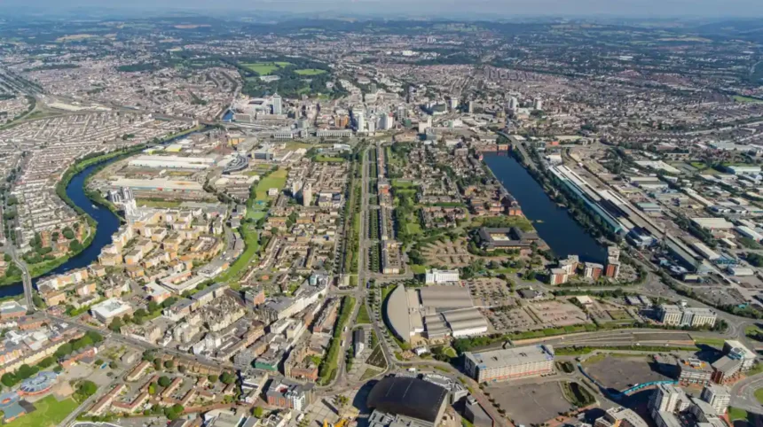
Cardiff floods because of its geographical position, river network, low-lying coastal landscape, urban development and exposure to heavy rainfall. The River Taff, River Ely and River Rhymney drain large catchments into the Severn Estuary, where high tides and storm surges increase flood risk. Surface-water runoff, drainage pressure and climate change add further pressure to the city’s flood defences.
- What Makes Cardiff Geographically Vulnerable to Flooding?
- Which Rivers Cause Flooding in Cardiff?
- How Does Heavy Rainfall Cause Flooding in Cardiff?
- Why Does Cardiff Experience Surface-Water Flooding?
- Impermeable urban surfaces
- Blocked drains and drainage capacity
- Low points in roads and neighbourhoods
- Small watercourses and culverts
- How Do High Tides and the Severn Estuary Increase Cardiff’s Flood Risk?
- What Role Does Cardiff Bay Barrage Play in Flood Prevention?
- Which Areas of Cardiff Face Flooding Risks?
- How Has Cardiff Experienced Flooding During Previous Storms?
- Storm Ciara in February 2020
- Storm Dennis in February 2020
- Storm Jorge in February 2020
- Why historical flood events matter
- How Does Climate Change Increase Flood Risk in Cardiff?
- Increased rainfall intensity
- Rising sea levels
- More intense storms
- What do official climate assessments indicate?
- How Does Urban Development Increase Flooding in Cardiff?
- Reduced natural water absorption
- Construction near rivers
- Pressure on existing infrastructure
- Sustainable urban development
- How Does Cardiff Manage and Prevent Flooding?
- Cardiff Council
- Natural Resources Wales
- Welsh Water
- Sustainable drainage improvements
- Coastal protection
- How Can Residents Check Flood Risk in Cardiff and Stay Safe?
- Check the official flood-risk map
- Register for flood warnings
- Prepare a household flood plan
- Avoid flooded roads
- Report flooding to the correct authority
- What Is the Future of Flood Prevention in Cardiff?
- Improving drainage infrastructure
- Expanding sustainable drainage systems
- Strengthening coastal defences
- Improving flood forecasting
- Planning for climate resilience
- Why Does Cardiff Flood?
Understanding why Cardiff floods requires examining its rivers, coastline, historical flood events, urban infrastructure and changing weather patterns. Flooding is not caused by one factor. Several natural and human-related processes combine to create flood risks across different parts of the Welsh capital.
What Makes Cardiff Geographically Vulnerable to Flooding?
Cardiff is vulnerable to flooding because it sits beside the Severn Estuary and contains several river valleys, low-lying coastal areas and densely developed neighbourhoods. Its geography exposes the city to river flooding, tidal flooding, intense rainfall and drainage-related problems.
Cardiff is the capital of Wales and lies on the south coast of the country. Its position beside the Severn Estuary connects the city to a large coastal water system. The Severn Estuary is the tidal mouth of the River Severn, where freshwater from inland river systems meets seawater.
The city’s geography creates several overlapping flood risks. Rivers carry rainwater from surrounding catchments towards Cardiff. The coastline exposes low-lying areas to tidal conditions. Urban development increases the volume of rainwater flowing across roads, pavements and buildings.
Three geographical characteristics explain much of Cardiff’s flood vulnerability.
Low-lying coastal geography
Cardiff contains low-lying land close to Cardiff Bay and the Severn Estuary. These areas depend on drainage infrastructure and coastal protection to manage water levels.
When heavy rainfall coincides with high tides, water movement through drainage outlets becomes more difficult. Water accumulates when drainage systems cannot discharge efficiently.
River valleys and catchment areas
A river catchment is the geographical area from which rainfall drains into a particular river. Cardiff receives water from extensive catchments extending beyond its administrative boundaries.
Rainfall in surrounding areas travels downstream through rivers and tributaries. Consequently, flooding in Cardiff does not always originate from rainfall inside the city.
Urban development
Cardiff contains residential neighbourhoods, commercial districts, transport infrastructure and industrial land. Buildings, roads and paved surfaces reduce the amount of rainfall that naturally enters the soil.
This increases surface runoff and places additional pressure on drainage systems.
The combination of coastal geography, river catchments and urban development makes flood management an important part of Cardiff’s long-term planning.

Which Rivers Cause Flooding in Cardiff?
Three principal river catchments influence Cardiff’s flood risk: the River Taff, River Ely and River Rhymney. These rivers collect rainfall from surrounding areas and carry water towards Cardiff Bay and the Severn Estuary, increasing flood risks during prolonged rainfall.
The rivers flowing through Cardiff form an important part of its drainage network. Natural Resources Wales (NRW) manages flood risk from designated main rivers, while Cardiff Council manages local flood risks.
The three main river systems have different geographical characteristics and flooding patterns.
River Taff
The River Taff is one of the most important rivers affecting Cardiff’s flood risk.
It is approximately 64 kilometres long and flows from the Brecon Beacons area towards Cardiff Bay. Its catchment extends well beyond the city boundary.
The river passes through areas including:
- Radyr.
- Llandaff.
- Llandaff North.
- Riverside.
- Cardiff city centre.
- Grangetown.
The River Taff catchment contains extensive urban development and hard surfaces. Cardiff Council’s 2024 Local Flood Risk Strategy describes the catchment as highly responsive to rainfall.
This means river levels can rise rapidly following heavy rain. Rainfall across the upper catchment also affects water levels downstream.
Storms Dennis, Ciara and Jorge in 2020 demonstrated the importance of managing rainfall across the wider Taff catchment. Flooding incidents occurred in communities connected to the river system.
River Ely
The River Ely influences flood risk across western Cardiff.
Its catchment includes communities such as:
- Ely.
- Caerau.
- Creigiau.
- St Fagans.
- Pentyrch.
- Canton and surrounding areas.
The River Ely receives water from several tributaries and surrounding drainage areas. Heavy rainfall increases river flows and raises the possibility of water overflowing onto nearby land.
Cardiff Council’s 2024 strategy identifies the Ely catchment as an important area for surface-water and small-watercourse flood management. The council also identifies recurring highway flooding issues within this catchment.
River Rhymney
The River Rhymney affects eastern Cardiff.
Its catchment includes communities such as Rumney, Llanrumney, St Mellons and surrounding areas.
The river system is particularly important because the eastern part of Cardiff connects with the tidal environment of the Severn Estuary.
Cardiff Council’s 2024 Local Flood Risk Strategy identifies the Rhymney catchment as the only Cardiff catchment directly influenced by the Severn Estuary tidal range.
The catchment therefore requires consideration of rainfall, river levels and tidal conditions when assessing flood risk.
How Does Heavy Rainfall Cause Flooding in Cardiff?
Heavy rainfall causes flooding in Cardiff when rainwater enters rivers, drains and streets faster than these systems can manage it. Prolonged rainfall raises river levels, while intense downpours overwhelm drainage networks and create surface-water flooding.
Rainfall is one of the most important causes of flooding in Cardiff. The effects depend on rainfall intensity, duration, ground conditions and the capacity of drainage infrastructure.
Two rainfall patterns create particularly serious problems.
Prolonged rainfall
Prolonged rainfall occurs when rain continues over several hours or days.
The ground gradually becomes saturated. Saturated soil absorbs less additional water, increasing the amount of rainfall flowing towards streams and rivers.
This process increases river discharge. River discharge describes the volume of water flowing through a river over a particular period.
When river discharge exceeds the capacity of the channel, water spills onto surrounding land.
Intense rainfall
Intense rainfall occurs when large quantities of rain fall within a short period.
Urban drainage systems have limited capacity. When rainfall exceeds that capacity, water accumulates on roads, pavements, gardens and other low-lying surfaces.
This creates surface-water flooding.
Natural Resources Wales identifies surface-water flooding as a separate flood category because it does not require a river to overflow. It occurs when rainfall cannot drain away or soak into the ground quickly enough.
Why rainfall outside Cardiff matters
The River Taff, River Ely and River Rhymney have catchments extending beyond the city.
Rainfall in surrounding parts of South Wales travels through tributaries and rivers towards Cardiff. This increases river levels even when rainfall within central Cardiff is relatively limited.
Flood management therefore requires monitoring conditions across entire catchments rather than focusing exclusively on rainfall within the city.
Why Does Cardiff Experience Surface-Water Flooding?
Cardiff experiences surface-water flooding because rainfall collects on roads, pavements and developed land when drainage systems cannot remove water quickly enough. Blocked drains, impermeable surfaces, intense storms and low-lying streets increase this risk.
Surface-water flooding is also called pluvial flooding. It occurs when rainwater remains above ground instead of entering drainage systems or soaking into the soil.
It is one of the most important local flood risks identified by Cardiff Council.
Impermeable urban surfaces
Impermeable surfaces prevent water from naturally entering the ground.
Examples include:
- Concrete roads.
- Asphalt car parks.
- Building roofs.
- Paved footpaths.
- Commercial developments.
These surfaces increase the speed at which rainwater travels across urban areas.
In undeveloped landscapes, vegetation and soil absorb some rainfall. In built-up neighbourhoods, more water reaches drainage systems within a shorter period.
Blocked drains and drainage capacity
Road drains collect rainwater and direct it into underground drainage networks.
Leaves, litter, sediment and other debris obstruct drainage openings. Blockages reduce the amount of water that drains away during rainfall.
Even functioning drains experience pressure during exceptionally heavy downpours.
Cardiff Council identifies surface-water runoff exceeding drainage capacity as a major cause of local flooding. Its 2024 strategy also includes investigations and remedial drainage works as flood-management measures.
Low points in roads and neighbourhoods
Water naturally moves downhill under gravity.
Road dips, underpasses, low-lying junctions and poorly drained open spaces collect runoff from surrounding surfaces.
These locations experience localised flooding even when nearby rivers remain within their banks.
Small watercourses and culverts
Small watercourses include streams, brooks, ditches and drainage channels.
A culvert is an enclosed structure that carries water underneath roads, railways or buildings.
Blocked or restricted culverts reduce the amount of water that can pass through them. During heavy rainfall, water backs up and creates flooding upstream.
This explains why flooding sometimes affects individual streets rather than entire neighbourhoods.
How Do High Tides and the Severn Estuary Increase Cardiff’s Flood Risk?
High tides increase Cardiff’s coastal flood risk by raising water levels along the Severn Estuary and restricting the discharge of rainwater through drainage outlets. Strong winds, storm surges and high river flows create additional pressure on coastal defences.
The Severn Estuary is an important geographical feature influencing Cardiff’s coastal flood risk.
An estuary is a coastal area where freshwater from rivers meets seawater. Its water levels change with the tides.
The Severn Estuary experiences a particularly large tidal range. This creates important challenges for coastal flood management.
High tides
High tides raise water levels along the coastline and connected waterways.
During high tides, drainage outlets can face increased resistance when releasing rainwater into coastal waters.
If heavy rainfall occurs at the same time, water accumulates within drainage networks and low-lying areas.
Storm surges
A storm surge occurs when strong winds and atmospheric pressure changes raise coastal water levels above normal tidal predictions.
Storm surges increase the amount of water pressing against coastal defences.
When a storm surge coincides with a high astronomical tide, the combined water level increases coastal flooding risk.
Tidal influence on river systems
The tidal environment influences water movement around the lower reaches of Cardiff’s waterways.
The River Rhymney catchment is particularly relevant because Cardiff Council identifies it as the city’s catchment directly influenced by the Severn Estuary tidal range.
This connection makes coordinated management of river levels, coastal conditions and drainage outlets important.
Coastal defence infrastructure
Cardiff uses coastal infrastructure to reduce flood risks.
However, coastal defences do not eliminate flooding completely. Water can overtop defences when levels exceed their design capacity. Damage or failure can also reduce protection.
Natural Resources Wales therefore includes coastal flooding and river flooding as separate categories in its flood-risk assessments.
What Role Does Cardiff Bay Barrage Play in Flood Prevention?
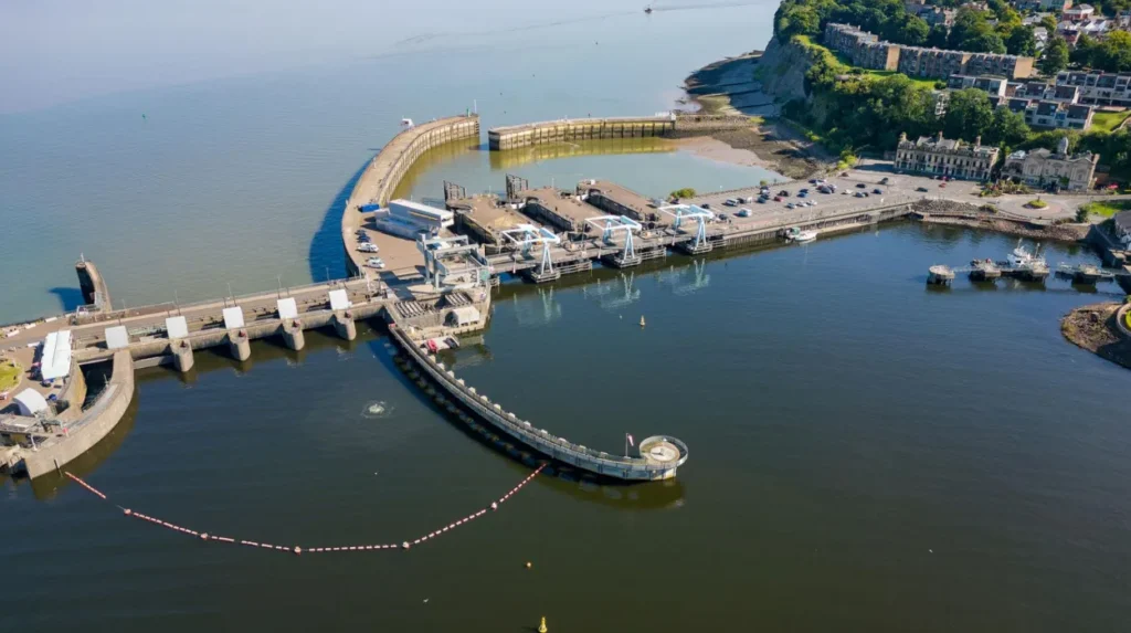
Cardiff Bay Barrage helps manage water levels within Cardiff Bay by controlling the movement of water between the bay and the Severn Estuary. It supports flood management, but it does not protect every Cardiff neighbourhood from river, surface-water or coastal flooding.
The Cardiff Bay Barrage is a major infrastructure project connecting the Cardiff Bay waterfront with the Severn Estuary.
The barrage transformed the former tidal dockland environment into a freshwater bay.
It also forms part of Cardiff’s wider approach to managing coastal and water-level risks.
How the barrage works
The barrage contains gates and water-control infrastructure that regulate water movement between Cardiff Bay and the estuary.
Its operation helps maintain controlled water levels within the bay.
Cardiff Council identifies the barrage as one of the city’s flood-prevention measures. The council also explains that the barrage helps lower water levels in the bay.
Why the barrage cannot prevent every flood
The barrage addresses a specific part of Cardiff’s water-management system.
It does not prevent rainfall from overwhelming street drains. It does not stop every river from rising after prolonged rainfall. It also does not remove the need for coastal defences elsewhere along the coastline.
Flood protection depends on several interconnected systems, including:
- River management.
- Surface-water drainage.
- Coastal protection.
- Water-level monitoring.
- Emergency planning.
The barrage therefore forms one component of Cardiff’s flood-management infrastructure rather than a complete solution.
Which Areas of Cardiff Face Flooding Risks?
Flood risks vary across Cardiff because different neighbourhoods connect to different river catchments, drainage systems and coastal environments. Areas including Riverside, Grangetown, Butetown, Ely, Caerau, Rumney and Roath require consideration in local flood-risk assessments.
Cardiff Council’s 2024 Local Flood Risk Strategy assesses communities across the River Ely, River Taff and River Rhymney catchments.
Its Communities at Risk Register analysis identifies neighbourhoods requiring attention for surface-water and small-watercourse flooding.
Western Cardiff
The River Ely catchment influences western parts of Cardiff.
Communities identified in the council’s catchment assessment include:
- Ely.
- Caerau.
- Creigiau.
- St Fagans.
- Pentyrch.
Rainfall runoff, small watercourses and highway drainage contribute to local flood risks in this area.
Central Cardiff
The River Taff catchment runs through the centre of Cardiff.
The council’s assessment includes:
- Riverside.
- Llandaff.
- Llandaff North.
- Canton.
- Grangetown.
- Butetown.
- Radyr.
The Taff catchment’s rapid response to rainfall makes monitoring river levels particularly important.
Eastern Cardiff
The River Rhymney catchment influences eastern communities.
The council’s assessment identifies:
- Roath.
- Rumney.
- Llanishen.
- Llanrumney.
- Pentwyn.
- St Mellons.
The catchment’s relationship with the Severn Estuary also introduces tidal considerations.
What do the council’s risk rankings mean?
Cardiff Council’s 2024 strategy includes surface-water rankings from the Welsh Communities at Risk Register.
For example, Roath appears at rank 74 within the Rhymney catchment assessment, while Butetown appears at rank 65 within the Taff catchment assessment.
These figures are rankings within the national register, not annual probabilities of flooding or guarantees that a particular property will flood.
The council’s strategy also provides separate flood-risk mapping for each catchment. Property owners should use the official flood maps to assess their individual locations.
How Has Cardiff Experienced Flooding During Previous Storms?
Cardiff’s flood history demonstrates how severe rainfall across South Wales affects river catchments, urban drainage and local communities. Storms Dennis, Ciara and Jorge in 2020 highlighted the vulnerability of the River Taff catchment and the importance of managing flood risks beyond Cardiff.
Historical flood events provide important evidence for understanding the city’s flood vulnerability.
Storm Ciara in February 2020
Storm Ciara brought severe weather and heavy rainfall to parts of the United Kingdom in February 2020.
The rainfall increased pressure on river systems and drainage infrastructure across Wales.
For Cardiff, the event demonstrated the importance of monitoring rainfall across the wider river catchments rather than focusing only on the city.
Storm Dennis in February 2020
Storm Dennis brought exceptionally heavy rainfall to South Wales in February 2020.
The storm affected communities across the River Taff, River Ely and surrounding catchments. River levels increased significantly, creating serious flooding problems across the region.
Cardiff Council’s 2024 Local Flood Risk Strategy specifically references Storms Dennis, Ciara and Jorge when discussing the rapid response of the Taff catchment to rainfall.
The council also highlights the importance of considering flooding incidents outside Cardiff’s administrative boundaries because upstream rainfall directly influences downstream river levels. cardiff.moderngov.co.uk+1
Storm Jorge in February 2020
Storm Jorge followed the severe weather affecting South Wales during February 2020.
Its inclusion in Cardiff Council’s flood strategy reinforces the importance of understanding how successive storms affect already vulnerable catchments.
When repeated rainfall occurs, the ground becomes saturated and river levels remain elevated. Additional rainfall then increases pressure on drainage systems and flood defences.
Why historical flood events matter
Previous flooding incidents help local authorities identify vulnerable infrastructure and improve future flood-management planning.
They also provide evidence for:
- Identifying locations that experience repeated flooding.
- Improving drainage infrastructure.
- Reviewing flood-defence performance.
- Updating flood-risk assessments.
- Improving emergency response arrangements.
Historical events demonstrate that Cardiff’s flood vulnerability is connected to wider weather conditions across South Wales.
How Does Climate Change Increase Flood Risk in Cardiff?
Climate change increases Cardiff’s flood risk through heavier rainfall, rising sea levels, more intense storms and greater pressure on coastal and river defences. These changes increase the importance of drainage improvements, sustainable development and long-term flood-resilience planning.
Climate change is an important consideration in Cardiff’s future flood management.
It influences both rainfall patterns and coastal conditions. These changes affect how frequently flooding occurs and how severe individual events become.
Increased rainfall intensity
A warmer atmosphere holds more moisture. This increases the potential for intense rainfall when suitable weather conditions develop.
Heavy rainfall places additional pressure on:
- River channels.
- Surface-water drains.
- Culverts.
- Urban roads.
- Flood-storage areas.
More intense rainfall increases the likelihood of flash flooding, particularly in developed catchments.
Rising sea levels
Sea-level rise increases the baseline water level along the Severn Estuary.
Higher baseline sea levels reduce the available capacity of coastal systems to accommodate storm surges and exceptionally high tides.
This creates additional pressure on coastal defences and drainage outlets.
More intense storms
Storms can combine heavy rainfall, strong winds and elevated coastal water levels.
These conditions create multiple flood pressures at the same time.
For example, heavy rainfall increases river discharge while strong winds and high tides increase coastal water levels.
What do official climate assessments indicate?
Natural Resources Wales’ 2025–2026 Flood Risk Management Annual Report identifies substantial future increases in flood exposure across Wales.
Its assessment indicates that by 2120:
- More than 131,000 properties are projected to be at risk from the sea.
- Nearly 131,000 properties are projected to be at risk from rivers.
- More than 48,000 additional properties are projected to be at risk from surface water and small streams.
These are Wales-wide projections, not Cardiff-specific property totals. However, they demonstrate the growing importance of long-term flood adaptation across the country. naturalresourceswales.gov.uk+1
Cardiff Council’s 2024 Local Flood Risk Strategy also incorporates climate change into its flood-management objectives. It identifies stronger coastal defences, drainage improvements and sustainable drainage systems as important adaptation measures.
How Does Urban Development Increase Flooding in Cardiff?
Urban development increases flooding when construction replaces natural soil and vegetation with impermeable surfaces. These surfaces accelerate rainwater runoff, reduce natural water absorption and increase pressure on Cardiff’s drainage networks, rivers and existing flood-management infrastructure.
Cardiff’s development as a major commercial, residential and transport centre has changed how water moves through the city.
Buildings, roads, car parks and paved public spaces create surfaces that prevent natural infiltration.
Reduced natural water absorption
In undeveloped areas, rainwater enters the soil and gradually moves into groundwater systems.
Vegetation also slows surface runoff and helps retain water.
Urban development reduces these natural processes. More rainwater travels directly towards drains and rivers.
Construction near rivers
Development close to rivers requires careful flood-risk assessment.
River floodplains provide natural space for water during high-flow conditions. Construction and unsuitable land use within these areas can reduce the available space for floodwater.
This increases the importance of development controls and appropriate drainage design.
Pressure on existing infrastructure
Older drainage systems were designed around particular rainfall conditions and development patterns.
Additional buildings and paved areas increase runoff entering these systems.
Where drainage capacity does not increase at the same rate, heavy rainfall creates a greater risk of surface-water flooding.
Sustainable urban development
Cardiff Council promotes Sustainable Drainage Systems, commonly known as SuDS.
These systems imitate natural drainage processes and manage rainfall closer to where it falls.
Examples include:
- Rain gardens.
- Green roofs.
- Permeable paving.
- Vegetated drainage channels.
- Attenuation ponds.
These measures slow water movement, encourage infiltration and temporarily store excess rainfall.
Cardiff Council’s flood strategy identifies the installation of SuDS in new developments and existing urban areas as an important way to improve flood resilience.
How Does Cardiff Manage and Prevent Flooding?
Cardiff manages flood risk through river management, coastal defences, drainage maintenance, flood-risk planning, sustainable drainage systems and public warnings. Cardiff Council, Natural Resources Wales and Welsh Water have different responsibilities for managing individual sources of flooding.
Flood management requires cooperation between public authorities, infrastructure operators, businesses and residents.
Different organisations manage different parts of the city’s drainage and water systems.
Cardiff Council
Cardiff Council acts as the Lead Local Flood Authority under the Flood and Water Management Act 2010.
Its responsibilities include managing local flood risks associated with:
- Surface-water runoff.
- Groundwater.
- Ordinary watercourses, such as small streams and brooks.
The council also prepares local flood-risk strategies and investigates certain flooding incidents.
Its 2024 Local Flood Risk Strategy sets out measures and actions for improving flood resilience across Cardiff.
Natural Resources Wales
Natural Resources Wales manages flood risk from main rivers, the sea and reservoirs.
Its responsibilities include flood forecasting, flood warnings, river monitoring and managing relevant flood-defence infrastructure.
Residents can use its flood-risk mapping service to identify areas exposed to different types of flooding.
Welsh Water
Dŵr Cymru Welsh Water manages public sewerage infrastructure.
Sewer flooding can happen when sewers become blocked, damaged or overwhelmed by incoming water.
Residents experiencing flooding from public sewers should contact Welsh Water.
Sustainable drainage improvements
SuDS help manage rainwater before it reaches conventional drainage networks.
Cardiff’s flood-management approach includes improving drainage infrastructure and encouraging sustainable development.
These measures reduce runoff and help manage water during intense rainfall.
Coastal protection
Cardiff also uses coastal flood-management infrastructure, including the Cardiff Bay Barrage.
The city’s wider coastal management approach considers the Severn Estuary, changing sea levels and the condition of existing defences.
The Severn Estuary Shoreline Management Plan provides a long-term framework for managing coastal erosion and flooding.
How Can Residents Check Flood Risk in Cardiff and Stay Safe?
Cardiff residents can check local flood exposure through Natural Resources Wales’ Flood Risk Assessment Wales Map and register for official flood warnings. Preparing an emergency plan, protecting important belongings and avoiding flooded roads helps reduce risks during severe weather.
Understanding local flood exposure is important for homeowners, tenants, landlords and businesses.
Flood risk varies between properties, even within the same neighbourhood. A general area-level assessment does not establish the precise risk to an individual building.
Check the official flood-risk map
Natural Resources Wales provides the Flood Risk Assessment Wales Map.
The service allows residents to examine risks associated with:
- River flooding.
- Coastal flooding.
- Surface-water flooding.
- Small watercourses.
- Reservoir flooding.
It also displays information about flood defences and areas that benefit from flood protection.
Residents can search using their postcode to examine local conditions.
The assessment distinguishes between high, medium, low and very low risk. These categories describe estimated annual probabilities rather than predictions that a property will definitely flood. naturalresources.wales+1
Register for flood warnings
Natural Resources Wales provides free flood warnings and alerts.
Residents should monitor warnings during periods of heavy rainfall, storms and unusually high tides.
Official warnings help households prepare before water levels become dangerous.
Prepare a household flood plan
Residents living in flood-prone areas should prepare before severe weather occurs.
Important precautions include:
- Keeping essential documents in waterproof storage.
- Moving electrical equipment above potential flood levels.
- Preparing a household emergency kit.
- Identifying safe evacuation routes.
- Keeping mobile phones charged.
- Knowing how to switch off electricity and gas safely.
Residents should never enter floodwater to retrieve belongings.
Avoid flooded roads
Floodwater hides road damage, open drains and submerged objects.
Even relatively shallow moving water creates serious hazards for pedestrians and drivers.
Residents should follow official travel advice and avoid walking or driving through floodwater.
Report flooding to the correct authority
Cardiff Council provides separate reporting arrangements depending on the source of flooding.
For immediate danger, residents should call 999.
For other flooding problems, the relevant contacts include:
- River or coastal flooding: Natural Resources Wales, 0300 065 3000.
- Surface water and highway flooding: Cardiff Council, 029 2087 2087.
- Water mains and sewer flooding: Welsh Water, 0800 085 3968.
These reporting arrangements help ensure incidents reach the organisation responsible for the affected infrastructure.
Explore More Area Guide
Cardiff Climate and Weather Guide: Temperatures, Rainfall and Seasons
How to Report Noise Pollution in Cardiff: Council Guide
What Is the Future of Flood Prevention in Cardiff?
Cardiff’s future flood prevention depends on stronger drainage infrastructure, improved coastal protection, sustainable urban development and climate adaptation. Long-term planning must address river flooding, rising sea levels and surface-water runoff while protecting homes, transport networks and essential services.
Flood prevention will remain an important priority as Cardiff continues to grow.
The city’s 2024 Local Flood Risk Strategy establishes a framework for improving flood management across its three principal river catchments.
Improving drainage infrastructure
Maintaining and upgrading drainage networks reduces the likelihood of surface-water accumulation.
Future improvements include better monitoring of drainage systems, repairing vulnerable infrastructure and addressing recurring highway flooding locations.
Expanding sustainable drainage systems
SuDS provide additional capacity for managing rainfall in developed areas.
Rain gardens, permeable surfaces and green infrastructure reduce the amount of water entering conventional drains during heavy rainfall.
These systems also improve urban green spaces and support environmental sustainability.
Strengthening coastal defences
Sea-level rise increases the importance of maintaining coastal protection infrastructure.
Cardiff’s coastal management planning considers the long-term effects of changing tides, storm surges and coastal erosion.
The Severn Estuary Shoreline Management Plan provides a framework for managing these risks over different planning periods.
Improving flood forecasting
Flood forecasting helps authorities identify dangerous conditions before flooding occurs.
Natural Resources Wales monitors river levels, rainfall and coastal conditions to provide relevant warnings.
Improved forecasting and public communication support faster emergency responses.
Planning for climate resilience
Climate resilience means preparing communities and infrastructure to withstand changing environmental conditions.
Cardiff Council’s strategy identifies climate adaptation, drainage improvements and coastal protection as important priorities.
Future development decisions must also consider flood exposure rather than relying entirely on existing flood defences.
The objective is to reduce flood damage, protect communities and maintain the city’s long-term environmental and economic resilience.
Why Does Cardiff Flood?
Cardiff floods because of the combined effects of its coastal geography, river catchments, heavy rainfall, urban development and drainage limitations.
The River Taff, River Ely and River Rhymney create important river-related flood risks. The Severn Estuary introduces additional tidal and coastal pressures. Urban surfaces increase runoff, while intense rainfall places pressure on drainage infrastructure.
The Cardiff Bay Barrage, coastal defences, drainage improvements and sustainable drainage systems help reduce these risks. However, no flood-management system eliminates every possibility of flooding.
Understanding local flood exposure, following Natural Resources Wales warnings and improving infrastructure are essential for protecting Cardiff’s communities.
As climate change increases pressure on river and coastal environments, effective flood management will remain central to Cardiff’s future development.
Why does Cardiff flood so often?
Cardiff experiences flooding because of heavy rainfall, overflowing rivers, coastal tides and urban drainage problems. Its location beside the Severn Estuary and three major river catchments increases its exposure to different types of flooding.