The Taff Trail is one of South Wales’ best-known walking and cycling routes. It connects Cardiff Bay with Brecon across approximately 55 miles (88–93 km), depending on the route measurement used by the source. The route follows the River Taff through Cardiff and the South Wales Valleys before reaching the mountainous landscapes around Brecon.
- What are the Taff Trail local sections in Cardiff?
- Where does the Cardiff section of the Taff Trail start?
- How long is the Taff Trail through Cardiff?
- What can you see on the Cardiff Bay to Bute Park section?
- What is the Bute Park to Llandaff section like?
- How does the Llandaff to Radyr section work for walkers and cyclists?
- What is the Radyr to Tongwynlais and Castell Coch section like?
- What surfaces and gradients should users expect on the Taff Trail?
- How accessible are the Cardiff Taff Trail sections?
- How can visitors plan a Taff Trail local walk or cycle?
- Why is the Taff Trail important to Cardiff’s walking and cycling network?
- Which Taff Trail local section is best for different visitors?
- What is the future relevance of Taff Trail local sections?
For Cardiff visitors, the full route does not need to be completed in one journey. The Cardiff section works particularly well as a series of shorter local sections. These sections connect Cardiff Bay, the city centre, Bute Park, Pontcanna, Llandaff, Radyr, Forest Farm, Tongwynlais and Castell Coch.
The Cardiff portion is largely traffic-free and combines riverside paths, parks, former railway corridors, urban green spaces and woodland. Visit Wales identifies the Cardiff-to-Castell Coch stretch as one of the most accessible ways to experience the trail without travelling deep into the Valleys.
What are the Taff Trail local sections in Cardiff?
The Taff Trail local sections are shorter parts of the Cardiff-to-Brecon route that can be walked or cycled independently, including Cardiff Bay–city centre, Bute Park–Llandaff, Llandaff–Radyr, Radyr–Tongwynlais and Tongwynlais–Castell Coch.
The Taff Trail is officially described as a 55-mile, waymarked route between Cardiff and Brecon. Its southern section runs through Cardiff before continuing north through Pontypridd and Merthyr Tydfil towards the Brecon area. The trail forms part of the wider National Cycle Network and is associated with National Cycle Route 8.
The Cardiff section has a distinct urban-to-green character. Cardiff Bay provides the southern starting point, while the route gradually moves through the city centre and riverside parks before reaching the northern suburbs.
Visit Wales describes the first section towards Castell Coch as approximately eight miles and highlights Bute Park, the River Taff, Llandaff Cathedral, Forest Farm and the castle as major features.
The concept of local sections is useful because the trail has different surfaces, gradients and environments. A visitor looking for a flat urban walk does not need to tackle the more demanding northern sections. A family cyclist can choose a shorter traffic-free ride. A long-distance cyclist can link several sections into a full-day journey.
Cardiff Council also maintains information about walking and cycling routes throughout the city. Its public rights-of-way information records approximately 200 km of public rights of way and bridleways across Cardiff.
The Taff Trail itself should not be confused with every nearby path. Some paths visible on mapping platforms are public rights of way, while others are permissive paths or adopted highways. Cardiff Council advises users to consult the Definitive Map when legal public-rights-of-way status is important.
Where does the Cardiff section of the Taff Trail start?
The Cardiff Taff Trail starts at Cardiff Bay, with the recognised starting point at Roald Dahl Plass, then travels through the city centre and north along the River Taff towards Bute Park, Llandaff, Forest Farm and Tongwynlais.
The recognised southern starting point is at Roald Dahl Plass in Cardiff Bay. Visit Wales identifies the Celtic Ring structure and a commemorative plaque as markers for the beginning of the trail.
Cardiff Bay provides a strong transport and visitor-access point. The area contains major attractions, restaurants, public spaces and pedestrian routes. It also connects with Cardiff city centre through several walking and cycling corridors.
From the Bay, the trail heads towards central Cardiff. The route passes close to major landmarks including the Principality Stadium and Cardiff Castle before reaching the extensive green space of Bute Park.
The southern section therefore combines several different environments within a relatively short distance. The first part is strongly urban. The middle section becomes increasingly green. The northern section follows the River Taff through parks, nature areas and woodland.
The route is particularly significant for understanding Cardiff’s relationship with the River Taff. The river historically supported transport, industry and trade across the region. The Taff corridor later became an important recreational and active-travel corridor as former industrial infrastructure was repurposed.
For visitors, Roald Dahl Plass is therefore more than a convenient starting location. It provides access to Cardiff Bay before the route moves into the historic centre and northern green spaces.
The trail can also be joined at other points. Visit Wales identifies Bute Park, Llandaff and Radyr as practical access points for shorter Cardiff journeys. An accessible cycling route from Cardiff Pedal Power in Bute Park to Radyr Weir covers approximately 14.15 km one way.
How long is the Taff Trail through Cardiff?
The Cardiff portion from the Bay towards Castell Coch is roughly eight miles, while commonly used shorter sections include the Bay-to-Bute Park, Bute Park-to-Llandaff, Llandaff-to-Radyr and Radyr-to-Castell Coch journeys.
Different official tourism sources provide slightly different distances for individual Cardiff sections. Visit Wales describes the Cardiff-to-Castell Coch section as approximately eight miles, while another Visit Wales guide gives a 6.5-mile figure for a commonly used Cardiff Bay-to-Castell Coch experience.
The difference reflects variations in route descriptions and exact start and finish points rather than a fundamentally different trail.
The complete Taff Trail is approximately 55 miles. Visit Wales gives 55 miles or 93 km, while Sustrans lists the Cardiff-to-Brecon route at 55 miles or 88.5 km.
For local Cardiff trips, distance is best considered in relation to the starting point.
A short city-centre outing can focus on Cardiff Bay, the river corridor and Bute Park. A longer journey can continue through Pontcanna and Llandaff towards Radyr. The route towards Tongwynlais and Castell Coch adds further distance and a more countryside-oriented environment.
The accessible Bute Park-to-Radyr route is approximately 14.15 km one way. Visit Wales describes it as predominantly flat, with minimal elevation and surfaces consisting mainly of tarmac and compact paths.
The Cardiff-to-Pontypridd section provides another useful benchmark. Visit Wales identifies this as approximately 16.5 miles or 26.5 km. It extends beyond the core Cardiff section and demonstrates how quickly the Taff Trail becomes a longer-distance journey once users continue north.
These distances make the trail suitable for different journey formats. A visitor can complete a short out-and-back walk, travel one way between transport points or build a longer cycling route.
What can you see on the Cardiff Bay to Bute Park section?
The Cardiff Bay to Bute Park section connects waterfront scenery with central Cardiff landmarks, including Roald Dahl Plass, the River Taff corridor, Principality Stadium and Cardiff Castle before reaching one of the city’s largest historic green spaces.
The Cardiff Bay-to-city-centre section provides the most urban part of the Taff Trail.
Roald Dahl Plass is the official starting area. The waterfront contains the Wales Millennium Centre, a major performing-arts venue, together with restaurants, cafés and public spaces.
The route then moves towards central Cardiff. The River Taff becomes the defining geographical feature as the trail heads north.
The Principality Stadium stands close to the route in central Cardiff. It is the national stadium of Wales and hosts major sporting and cultural events.
Cardiff Castle is another important landmark. The castle occupies a central position beside Bute Park and contains archaeological and architectural evidence spanning approximately 2,000 years. Visit Wales identifies it as one of Cardiff’s principal heritage attractions.
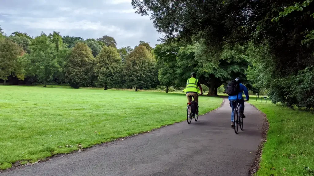
Bute Park then changes the character of the journey. The route enters a large urban parkland environment with riverside paths, mature vegetation and open green spaces.
Bute Park has Green Flag Award recognition and forms an important recreational area within Cardiff. The park also provides facilities for cyclists and walkers.
This section works particularly well for visitors who want to combine sightseeing with outdoor activity. The distance can be adjusted without committing to the complete trail.
The urban setting also means that the section has strong access to public transport, cafés, attractions and city-centre facilities. That makes it one of the most practical Taff Trail segments for short visits.
What is the Bute Park to Llandaff section like?
The Bute Park to Llandaff section follows the River Taff through increasingly green surroundings and connects central Cardiff with Llandaff Cathedral, riverside paths and nearby nature areas without requiring a long-distance journey outside the city.
Bute Park marks the transition from central Cardiff to the city’s northern riverside landscape.
The route continues alongside the River Taff. The surroundings become quieter as dense urban development gives way to parkland and open spaces.
One major landmark is Llandaff Cathedral, a historic place of worship located in the Llandaff area of Cardiff. Its presence adds a significant heritage element to this part of the route.
The route also connects with green spaces around the Taff corridor. Visit Wales specifically identifies the Cardiff Bay-to-Castell Coch experience as passing through Bute Park, Llandaff Cathedral and Forest Farm Nature Reserve.
The combination of river, parkland and heritage sites gives this section a different character from the waterfront starting point.
The surface remains suitable for ordinary leisure cycling and walking on the appropriate route sections. The wider Taff Trail uses several surface types, including smooth tarmac, compacted paths, gravel and forest tracks.
Users should therefore distinguish between the easier Cardiff urban sections and the more varied surfaces found farther north.
Llandaff also provides an important access point for visitors who do not want to begin at Cardiff Bay. Rail connections in the wider corridor support point-to-point travel, although users should check current transport information before travelling.
The section is also relevant to runners and recreational cyclists. The river corridor provides a continuous route away from heavy urban traffic for substantial parts of the journey.
How does the Llandaff to Radyr section work for walkers and cyclists?
The Llandaff to Radyr section continues north along the River Taff through green corridors and nature areas, offering a predominantly easy route with access to railway stations and Forest Farm before reaching Radyr Weir.
The Llandaff-to-Radyr section represents the strongest transition into Cardiff’s northern green corridor.
The route remains closely associated with the River Taff. The waterway provides a continuous geographical reference point as the trail moves through parks and open land.
Forest Farm Nature Reserve is one of the significant natural areas connected with the wider Cardiff Taff Trail corridor. It provides habitat and open-space value within the urban area.
Radyr provides another useful endpoint because it has a railway station. Visit Wales identifies Llandaff and Radyr railway stations as points where users can join or leave the accessible Taff Trail cycling route.
The accessible route from Cardiff Pedal Power in Bute Park to Radyr Weir is approximately 14.15 km one way. It has minimal elevation and uses tarmac and compact paths.
Radyr Weir is a notable riverside feature and provides a clear northern endpoint for a shorter Cardiff cycling journey.
This section is especially useful for visitors who want a longer recreational ride without travelling into the more demanding terrain north of Cardiff.
The distinction between this section and the wider Taff Trail becomes important at Tongwynlais. Beyond the core Cardiff corridor, the trail introduces steeper sections, woodland and more varied terrain.
For walkers, the section can function as an out-and-back route. For cyclists, the railway network provides opportunities to structure a one-way journey where current services and bike policies permit.
Users should remain on the designated route and respect other path users. Cardiff Council states that public rights of way are legal routes and that cyclists on bridleways must give way to other users.
What is the Radyr to Tongwynlais and Castell Coch section like?
The Radyr-to-Tongwynlais and Castell Coch section introduces more woodland, countryside and elevation while retaining the Taff corridor, making it a natural progression from Cardiff’s flatter urban trail sections toward the wider Valleys landscape.
The northern Cardiff section changes the physical character of the trail.
Tongwynlais sits near the northern edge of Cardiff and provides access to Castell Coch, one of the most recognisable historic buildings in the area.
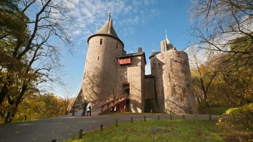
Castell Coch is a nineteenth-century Gothic Revival castle built above Tongwynlais. The building occupies a wooded hillside and creates a distinctive endpoint for many Cardiff-based Taff Trail journeys.
Visit Wales describes the Cardiff-to-Castell Coch section as a popular traffic-free family cycling route. It also notes a short quiet-road section through Tongwynlais and a short, steep climb towards the castle.
This distinction is important for route planning. Most of the earlier Cardiff sections are comparatively gentle, while the approach to Castell Coch introduces a sharper gradient.
An alternative lower-level tarmac route runs below the castle. Visit Wales identifies this as an option for users who do not want to take the steeper forest route. The lower route passes near Taff’s Well railway station before reconnecting farther north.
The area therefore provides route choice without requiring users to abandon the Taff Trail corridor.
For cyclists, the surface becomes more varied as the route moves away from central Cardiff. Visit Wales recommends wider tyres for cyclists tackling sections containing dirt tracks.
For walkers, the combination of river, woodland and heritage makes the northern Cardiff section substantially different from the waterfront.
The Tongwynlais section also marks the beginning of a broader Valleys experience. Beyond Castell Coch, the route continues towards Pontypridd and then Merthyr Tydfil.
What surfaces and gradients should users expect on the Taff Trail?
Taff Trail surfaces vary from smooth tarmac and compact paths in Cardiff to gravel, dirt tracks and forest paths farther north, while the Cardiff core remains generally gentle before steeper terrain appears near Castell Coch and beyond.
Surface quality is one of the most important practical factors when choosing a Taff Trail local section.
The Cardiff urban sections generally provide firm surfaces suitable for ordinary walking and leisure cycling. The accessible Bute Park-to-Radyr route is specifically described as using tarmac and compact paths.
Further north, the route becomes more varied.
Travel Trade Wales describes the full trail as using riverside paths, old railway paths, forest paths, canals and green spaces. Surfaces range from smooth tarmac to gravel and forest tracks.
This means equipment should match the selected section.
Standard walking shoes are appropriate for the established Cardiff paths. Leisure bikes and hybrid bicycles suit the firmer sections. Wider tyres become more useful on rougher parts of the longer route.
Gradients also change progressively.
The Cardiff river corridor is largely gentle. The approach to Castell Coch includes a short, stiff climb. North of Merthyr Tydfil, the route becomes substantially more challenging, climbing towards Pontsticill and open moorland near Torpantau.
The full trail therefore has a much wider difficulty range than the Cardiff local sections alone.
Visitors should not use the difficulty of the complete 55-mile route to judge a short Cardiff outing. The accessible Bute Park-to-Radyr section demonstrates that a substantial distance can remain predominantly flat.
Weather also affects surface conditions. Rain can make gravel, dirt and forest sections less comfortable. Checking current route information before departure remains important.
How accessible are the Cardiff Taff Trail sections?
Several Cardiff Taff Trail sections are accessible for leisure cycling and walking, with the Bute Park-to-Radyr route offering a predominantly flat, low-gradient option designed for families, beginners, trike users and other recreational riders.
Accessibility differs between individual sections.
Visit Wales describes the Bute Park-to-Radyr route as an accessible cycle route approximately 14.15 km long in one direction. The route has minimal elevation and mainly uses tarmac and compact paths.
The route is designed for leisure cycling rather than technical riding. It is identified as suitable for families, beginner cyclists and trike users.
This makes the Cardiff section significantly different from the more challenging terrain farther north.
Accessibility also depends on the exact entrance, surface, weather and user’s mobility requirements. A route that is flat can still contain narrow points, shared-use areas, bridges, crossings or surface changes.
The trail is shared by different users. Walkers, cyclists and other recreational users occupy parts of the corridor. Cardiff Council states that cyclists on bridleways must give way to other users.
The wider Cardiff active-travel network is also developing. Cardiff Council’s cycleway programme includes proposed routes connecting communities with major destinations such as Cardiff city centre and Cardiff Bay. Its Active Travel Network Map sets out a 15-year plan for walking and cycling improvements.
These improvements are relevant to the long-term connectivity of Cardiff’s walking and cycling network.
Users with specific accessibility requirements should check the latest local route information before departure. Conditions and infrastructure can change because of maintenance, construction, flooding or other temporary restrictions.
How can visitors plan a Taff Trail local walk or cycle?
Visitors can plan a Taff Trail journey by selecting a defined Cardiff section, checking current route conditions, choosing suitable footwear or bicycle equipment, identifying transport access and allowing time for landmarks and rest stops.
Planning starts with choosing the correct distance.
A short visitor journey can focus on Cardiff Bay and Bute Park. A medium-length trip can continue towards Llandaff and Radyr. A longer outing can extend to Tongwynlais and Castell Coch.
The starting point should match the intended activity.
Cardiff Bay provides the recognised southern start. Bute Park provides a central access point. Llandaff and Radyr provide useful intermediate access points. Tongwynlais and Castell Coch provide a northern Cardiff endpoint.
Public transport is particularly useful for point-to-point journeys. Travel Trade Wales identifies train stations at Cardiff Bay, Pontypridd, Merthyr Tydfil and Brecon along the wider Taff Trail corridor.
Cyclists should confirm current bicycle carriage rules before relying on rail travel.
Facilities also vary by section. Cardiff Bay and central Cardiff have extensive cafés, restaurants and toilets. Travel Trade Wales identifies toilet facilities at Cardiff Bay and Bute Park, as well as at facilities farther north.
A practical Cardiff itinerary therefore does not require carrying supplies for the entire 55-mile route.
Weather preparation is also important. Cardiff’s riverside paths are exposed to rain and changing conditions. Comfortable footwear, appropriate clothing and water remain basic requirements for longer walks.
Cyclists should select a bicycle suited to the surface. A hybrid or leisure bicycle is appropriate for many Cardiff sections. Wider tyres provide additional suitability for rougher parts of the complete trail.
Users should also respect wildlife, pedestrians, cyclists and local communities. The trail passes through residential and environmentally sensitive areas.
Why is the Taff Trail important to Cardiff’s walking and cycling network?
The Taff Trail provides a continuous active-travel corridor linking Cardiff Bay, the city centre and northern Cardiff with the South Wales Valleys, while connecting recreational travel with parks, heritage sites, former railway infrastructure and river landscapes.
The Taff Trail has importance beyond leisure.
It provides a long-distance walking and cycling connection between Cardiff and the Valleys. Its Cardiff section links major destinations without requiring users to remain on conventional roads for much of the route.
The route also demonstrates how former industrial infrastructure can support modern recreation and active travel. Travel Trade Wales notes the use of old railway paths and canal-related infrastructure along the wider trail.
The River Taff itself has strong historical importance. The river formed a major transport and industrial corridor for Cardiff and the surrounding Valleys. The development of Cardiff as a major port was closely connected to the movement of resources and goods through the Taff and associated transport networks.
The modern trail reflects a different use of the same geographical corridor.
Walking and cycling now provide recreational and sustainable transport opportunities through areas once dominated by industrial activity.
The trail also supports Cardiff’s broader active-travel objectives. Cardiff Council’s current cycleway programme aims to create continuous, intuitive and comfortable routes connecting communities with major destinations.
For visitors, this means the Taff Trail functions as both an attraction and a transport corridor.
For residents, sections of the trail support commuting, exercise and everyday travel. Visit Wales describes the route as an important part of the cycling experience for Cardiff residents and identifies its popularity with families, visitors and long-distance cyclists.
The combination of urban access, natural scenery, heritage and active travel gives the Cardiff sections enduring relevance.
Explore More Area Guide
Cardiff’s Oldest Bike Shops Guide – Cardiff 2026
Independent Cafés in Roath Guide – Cardiff 2026
Which Taff Trail local section is best for different visitors?
Cardiff Bay to Bute Park suits short sightseeing trips, Bute Park to Radyr suits flatter leisure cycling, and the route towards Tongwynlais and Castell Coch suits visitors seeking longer distances, woodland, heritage and more demanding terrain.
Different local sections serve different purposes.
Cardiff Bay to Bute Park is the most convenient option for visitors prioritising central attractions. It combines the waterfront, city centre, Principality Stadium, Cardiff Castle and Bute Park.
Bute Park to Llandaff provides a stronger riverside and green-space experience. It works well for visitors who want to leave the busiest central streets while remaining close to Cardiff.
Llandaff to Radyr extends the journey into the northern green corridor. The section provides access to Forest Farm and Radyr Weir, while nearby rail connections create additional planning options.
Radyr to Tongwynlais introduces a more rural character. The route becomes more varied as it approaches the northern edge of Cardiff.
Tongwynlais and Castell Coch provide the strongest heritage-focused endpoint. The castle sits within a wooded landscape and adds a significant architectural destination to the trail.
The accessible Bute Park-to-Radyr section is particularly useful for beginners and leisure cyclists because of its predominantly flat terrain and compact surfaces.
Long-distance users can continue beyond Cardiff. The route passes through Pontypridd and Merthyr Tydfil before entering increasingly mountainous terrain towards Brecon.
The key principle is simple: the Taff Trail is a continuous route, but it is also a collection of practical local journeys.
What is the future relevance of Taff Trail local sections?
The Cardiff Taff Trail sections remain strategically relevant because they connect major visitor destinations with residential communities, green spaces and active-travel infrastructure while providing a long-distance link between Cardiff and the South Wales Valleys.
The long-term relevance of the Taff Trail is closely connected with Cardiff’s continued investment in walking and cycling.
Cardiff Council is developing multiple cycleway proposals connecting the city centre with areas including Cardiff Bay, Llandaff, North West Cardiff, Roath Park and other communities.
These projects form part of a wider active-travel approach rather than replacing the Taff Trail.
The Taff Trail already provides a major north-south recreational corridor. Future improvements to surrounding cycling infrastructure can improve connections between neighbourhoods and the trail.
The route also has continuing tourism value. Visit Wales promotes the Taff Trail as a major walking and cycling attraction connecting Cardiff with Brecon and highlights the ability to experience the route in smaller sections.
Its geographic diversity strengthens that role. Cardiff Bay offers waterfront scenery. Central Cardiff provides heritage attractions. Bute Park and the Taff corridor provide urban nature. Llandaff adds historic architecture. Forest Farm provides natural habitat. Tongwynlais and Castell Coch introduce woodland and castle scenery.
Further north, the landscape develops into the South Wales Valleys and mountain country.
This progression allows visitors to select experiences according to time, fitness, transport access and interests without abandoning the wider Taff Trail.
For Cardiff Daily readers, the most useful approach is therefore to treat Taff Trail local sections as individual journeys within one nationally recognised route. The Cardiff sections provide accessible options for short walks, leisure cycling, sightseeing, family outings and longer active-travel trips.
Before travelling, users should check current route conditions, transport arrangements and any temporary closures. Cardiff Council provides current information for walking, cycling, public rights of way and transport, while Visit Wales provides route and visitor guidance.
What are the main Taff Trail local sections in Cardiff?
The main Cardiff sections include Cardiff Bay to Bute Park, Bute Park to Llandaff, Llandaff to Radyr, Radyr to Tongwynlais, and Tongwynlais to Castell Coch.