Cardiff’s flood defences protect communities, businesses, transport infrastructure and public spaces from flooding caused by rivers, heavy rainfall and rising tides. The city’s flood management system combines the Cardiff Bay Barrage, river flood alleviation structures, drainage networks, floodplains and sustainable drainage systems (SuDS).
- What Are Flood Defences in Cardiff?
- Why Does Cardiff Need Strong Flood Protection?
- How Does Cardiff’s Geography Influence Flood Risk?
- How Does Climate Change Affect Cardiff’s Flood Defences?
- How Does the Cardiff Bay Barrage Protect the City From Tidal Flooding?
- How Do the River Taff and River Ely Flood Defences Work?
- What Is the River Taff’s Role in Cardiff Flood Management?
- How Does the River Ely Influence Flood Risk?
- Why Is River Monitoring Important?
- What Flood Defences Protect Cardiff’s Residential Communities?
- Which Cardiff Communities Face Surface Water Flood Risk?
- What Do the Community Risk Rankings Mean?
- How Does the City Protect Low-Lying Communities?
- How Do Sustainable Drainage Systems Help Prevent Flooding in Cardiff?
- What Are the Main Types of Sustainable Drainage Systems?
- Why Are SuDS Important for New Cardiff Developments?
- How Do Cardiff’s Floodplains and Green Spaces Reduce Flooding?
- Who Is Responsible for Maintaining Cardiff’s Flood Defences?
- What Does Cardiff Council Do?
- What Does Natural Resources Wales Do?
- What Does Cardiff Harbour Authority Do?
- What Is Welsh Water’s Responsibility?
- How Does Cardiff Monitor and Maintain Its Flood Defences?
- What Lessons Have Cardiff Learned From Previous Flooding Events?
- How Can Cardiff Residents Check Their Local Flood Risk?
- What Is the Future of Flood Defences in Cardiff?
- Will Cardiff Strengthen Its Coastal Defences?
- Will Cardiff Invest in Better Drainage Infrastructure?
- How Will Climate Change Influence Future Flood Defence Planning?
- Why Are Cardiff’s Flood Defences Important for the City’s Future?
Cardiff is particularly exposed to flood risk because of its geographical position beside the Severn Estuary and the River Taff. Other important waterways, including the River Ely and River Rhymney, also influence flood conditions across the city. Low-lying areas face additional pressure from coastal tides, surface water accumulation and drainage restrictions during periods of heavy rainfall.
Flood protection in Cardiff is therefore not dependent on one structure. Cardiff Council, Natural Resources Wales (NRW), Cardiff Harbour Authority and other organisations work together to manage different sources of flooding.
Understanding how these defences operate helps residents identify local risks, understand flood warnings and recognise the importance of long-term investment in flood resilience.
What Are Flood Defences in Cardiff?
Flood defences in Cardiff are physical structures, drainage systems and natural landscape features designed to reduce flooding from rivers, rainfall and the sea. They include the Cardiff Bay Barrage, riverbanks, floodplains, drainage infrastructure and sustainable drainage systems that protect vulnerable communities.
Flood defences are part of flood risk management. Their purpose is to control water levels, reduce the likelihood of inundation and limit damage when extreme weather occurs.
In Cardiff, flood protection addresses three principal sources of flooding:
- River flooding: Occurs when waterways such as the River Taff, River Ely and River Rhymney exceed their normal capacity.
- Coastal and tidal flooding: Happens when high tides, storm surges and waves threaten low-lying coastal areas.
- Surface water flooding: Develops when heavy rainfall overwhelms drains, roads and other drainage infrastructure.
Cardiff also considers groundwater flooding, reservoir risks and flooding from smaller watercourses.
The city’s flood protection system combines engineered infrastructure with natural water management. Floodwalls and embankments provide physical barriers, while floodplains temporarily accommodate excess river water.
Cardiff Council’s Flood Risk Management Plan establishes how the authority manages local flooding from surface runoff, groundwater and ordinary watercourses. Its wider strategy supports the national flood and coastal erosion risk management framework for Wales.
Why Does Cardiff Need Strong Flood Protection?
Cardiff needs strong flood protection because its rivers, low-lying coastal geography and proximity to the Severn Estuary create overlapping flood risks. Heavy rainfall, high tides and rising sea levels increase pressure on homes, businesses, roads and essential infrastructure across vulnerable neighbourhoods.
Cardiff’s location creates several challenges for flood management. The River Taff flows through the city before reaching Cardiff Bay, while the River Ely also contributes water to the bay.
The Severn Estuary experiences a substantial tidal range. During high tides, seawater can restrict the discharge of river water into the estuary. This process is known as tidal locking.
When river levels rise while the estuary tide remains high, water has less opportunity to flow downstream. This increases pressure on rivers and nearby flood management infrastructure.
How Does Cardiff’s Geography Influence Flood Risk?
The city’s geography determines where floodwater accumulates and how quickly it moves through urban areas.
Cardiff contains low-lying communities around Cardiff Bay and the southern part of the city. Areas beside the River Taff, River Ely and River Rhymney also experience river-related flood risks.
Urban development creates additional challenges. Roads, buildings, car parks and paved surfaces prevent rainfall from naturally soaking into the ground. Water consequently flows towards drainage systems and low-lying locations.
How Does Climate Change Affect Cardiff’s Flood Defences?
Climate change increases the importance of long-term flood protection. Rising sea levels increase coastal flood pressure, while changing rainfall patterns influence river levels and surface water accumulation.
Natural Resources Wales reported in its 2025–26 annual report that approximately 275,000 properties across Wales face some form of flood risk. Its projections indicate that more than 131,000 properties will be at risk from the sea and nearly 131,000 from rivers by 2120.
These are Wales-wide figures, not Cardiff-specific property totals. They demonstrate why flood management requires continued investment and regular reassessment.
How Does the Cardiff Bay Barrage Protect the City From Tidal Flooding?
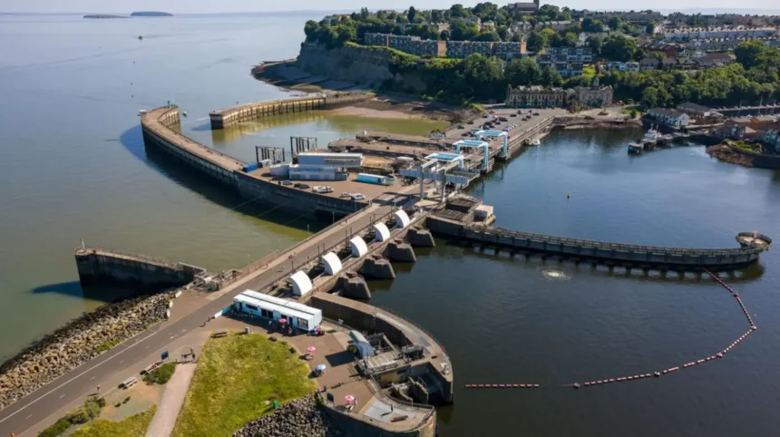
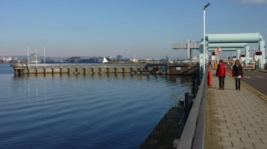
The Cardiff Bay Barrage is a major tidal control structure that separates Cardiff Bay from the Severn Estuary. Its five sluice gates regulate water movement, prevent high tides entering the bay and help manage river flows during periods of increased flood risk.
The Cardiff Bay Barrage is one of the city’s most important flood management structures. It extends approximately 1.1 kilometres from Cardiff docks towards Penarth.
The £220 million engineering project began in 1994 and was completed in 1999. It transformed the former tidal bay into a freshwater environment and supported the regeneration of Cardiff’s historic docklands.
What Are the Main Components of the Barrage?
The Cardiff Bay Barrage contains several engineering components that support water management and navigation.
Five sluice gates regulate water levels between Cardiff Bay and the Bristol Channel. Each gate measures approximately 7.5 metres high and 9 metres wide. Each can discharge more than 250,000 litres of water per second.
Three navigation locks allow boats to travel between Cardiff Bay and the Severn Estuary. Each lock is approximately 40 metres long, with two measuring 8 metres wide and one measuring 10.5 metres wide.
Bridges and control equipment support navigation and the operation of the barrage. The control room operates continuously throughout the year.
A fish pass allows migratory fish, including salmon and sea trout, to travel between the estuary and the River Taff and River Ely.
These components allow the barrage to manage tidal movements while supporting navigation and aquatic wildlife.
How Do the Barrage Sluice Gates Work?
The sluice gates respond to water-level differences between Cardiff Bay and the Severn Estuary.
When the estuary tide rises above the bay level, operators close the sluices to prevent seawater from entering the freshwater bay.
When the estuary level falls below the bay level, operators open the gates to release water from the bay.
The system also supports flood management. Natural Resources Wales provides information about expected river flooding from the Taff and Ely catchments. Cardiff Harbour Authority uses this information to manage bay levels and create additional capacity for incoming river water.
This process helps reduce pressure on the rivers during periods of high flow. It does not remove every flood risk from the surrounding communities.
How Do the River Taff and River Ely Flood Defences Work?
Cardiff’s river flood protection system manages water flowing through the River Taff and River Ely catchments. It combines riverbank infrastructure, flood alleviation projects, monitoring equipment and the Cardiff Bay Barrage to reduce flooding risks in nearby communities.
The River Taff and River Ely are important parts of Cardiff’s drainage geography. Both rivers flow towards Cardiff Bay and influence the city’s flood conditions.
What Is the River Taff’s Role in Cardiff Flood Management?
The River Taff flows approximately 64 kilometres from its source in the Brecon Beacons towards Cardiff Bay.
It passes through several communities before reaching central Cardiff. River levels respond to rainfall across the wider catchment, including locations outside the city boundary.
Cardiff Council’s Local Flood Risk Management Strategy identifies the Taff catchment as particularly responsive to rainfall. Its extensive built-up areas contain hard surfaces that increase the speed of surface runoff.
The strategy also identifies flooding incidents associated with Storms Ciara, Dennis and Jorge in 2020.
The council’s flood management programme includes projects around Radyr and Whitchurch. Its strategy identifies the following project stages:
- Greener Whitchurch construction.
- Radyr Court Road business case and construction.
- Nant y Wedal outline business case, full business case and construction.
These projects form part of the council’s wider programme for reducing flood risk in the Taff catchment. Their inclusion in the strategy does not mean every project has reached completion.
How Does the River Ely Influence Flood Risk?
The River Ely is another major watercourse affecting Cardiff’s flood management.
Its catchment includes communities such as Caerau, Ely, Creigiau, St Fagans and Pentyrch.
Cardiff Council’s strategy explains that the Ely catchment contains several watercourses and tributaries associated with recurring highway flooding incidents.
The River Ely also connects directly with Cardiff Bay’s water management system. The barrage regulates the movement of water between the bay and the estuary.
Flood management in the Ely catchment therefore requires attention to river levels, local drainage capacity and the effects of tidal conditions.
Why Is River Monitoring Important?
River monitoring helps authorities identify rising water levels before flooding becomes severe.
Monitoring systems provide information about water levels, rainfall conditions and the performance of drainage infrastructure.
Natural Resources Wales manages flood risk from designated main rivers, including the River Taff and River Ely. Cardiff Council manages local flood risks associated with smaller watercourses and surface water.
Cooperation between these organisations supports coordinated flood warnings and emergency responses.
What Flood Defences Protect Cardiff’s Residential Communities?
Cardiff protects residential communities through a combination of river defences, drainage improvements, coastal management, flood monitoring and natural water storage. Local protection priorities depend on the source of flooding and the characteristics of each neighbourhood.
Flood risk differs across Cardiff because the city contains three important river catchments: the Ely, Taff and Rumney catchments.
Cardiff Council uses the Communities at Risk Register (CaRR Wales) to assess and compare communities exposed to flooding.
Its local strategy identifies 25 Communities at Risk Register areas across Cardiff. cardiff.moderngov.co.uk
Which Cardiff Communities Face Surface Water Flood Risk?
The council’s strategy identifies several communities within the River Ely catchment, including:
- Caerau
- Ely
- Creigiau
- St Fagans
- Pentyrch
Within the River Taff catchment, identified communities include Butetown, Canton, Grangetown, Llandaff, Llandaff North, Radyr and Riverside.
The River Rumney catchment includes Roath, Rumney, Llanishen, Llanrumney, Pentwyn, Lisvane and St Mellons.
These locations appear in the council’s Communities at Risk Register assessment. Their inclusion does not mean every street or property within each community experiences the same flood probability.
What Do the Community Risk Rankings Mean?
The Communities at Risk Register helps authorities compare flood exposure and prioritise investment.
These figures represent the rankings published in the council’s strategy, not annual probabilities or individual property risk scores.
How Does the City Protect Low-Lying Communities?
Low-lying communities require coordinated flood management because water can accumulate when river levels and tides restrict drainage.
The Cardiff Bay Barrage manages tidal water entering the bay. Groundwater monitoring and pumping systems also support flood management in parts of southern Cardiff.
The council’s strategy identifies two operational pumped groundwater control systems in Grangetown, located at Merches Gardens and the Principality Stadium.
These systems help manage groundwater levels in areas affected by the historical changes associated with the barrage and local development.
How Do Sustainable Drainage Systems Help Prevent Flooding in Cardiff?
Sustainable Drainage Systems (SuDS) manage rainwater by slowing runoff, storing excess water and allowing natural infiltration. Cardiff uses SuDS planning requirements to reduce pressure on conventional drainage networks and limit surface water flooding from new developments.
SuDS are designed to replicate the natural movement of rainwater through the environment. They reduce the volume and speed of water entering conventional drainage systems.
Cardiff Council acts as the SuDS Approval Body (SAB). This responsibility supports the implementation of sustainable drainage requirements for qualifying new developments.
What Are the Main Types of Sustainable Drainage Systems?
Cardiff’s approach to sustainable drainage includes several techniques.
Rain gardens collect rainfall from roofs, pavements and other hard surfaces. Plants and soil help absorb and filter water.
Permeable paving allows rainwater to pass through specially designed surfaces rather than running directly into road drains.
Attenuation ponds temporarily store excess rainwater before releasing it at a controlled rate.
Swales are shallow, vegetated channels that direct and slow surface water runoff.
Green roofs retain some rainfall on building surfaces and reduce the amount of water entering drainage networks.
These features provide additional environmental benefits. They support biodiversity, improve green spaces and reduce pressure on urban drainage infrastructure.
Why Are SuDS Important for New Cardiff Developments?
New residential and commercial developments introduce additional hard surfaces. Roofs, driveways, roads and parking areas increase the amount of rainfall flowing across urban land.
Without appropriate drainage, this water increases pressure on existing systems.
Cardiff Council’s local flood strategy requires sustainable drainage to be considered in new development. The council also identifies retrofitting SuDS into existing urban areas as part of its climate resilience commitments.
The strategy incorporates a 40% uplift factor into the design, modelling and assessment of surface water drainage systems, SuDS and flood alleviation schemes to account for climate change.

How Do Cardiff’s Floodplains and Green Spaces Reduce Flooding?
Cardiff uses green spaces and floodplains to provide additional capacity for excess rainwater and river flows. These areas temporarily accommodate water during heavy rainfall, reducing pressure on drainage infrastructure and helping protect nearby residential and commercial locations.
Floodplains are areas of land beside rivers that naturally accommodate water when river levels rise.
Instead of directing every litre of excess water into engineered channels, floodplain management provides space for water to spread temporarily.
Cardiff Council identifies floodplains within green open spaces as part of its flood prevention measures. These areas are designed to accommodate higher river levels when necessary. Cardiff Council
How Do Green Spaces Support Flood Management?
Green spaces help reduce surface water runoff because soil and vegetation absorb and retain rainfall.
Parks, landscaped areas and open spaces also provide opportunities for sustainable drainage improvements.
Important green spaces across Cardiff include Bute Park, Victoria Park and other public recreational areas.
However, not every park is an officially designated flood storage area. Their general environmental benefits should not be confused with a specific engineered flood defence.
Why Is Natural Flood Management Important?
Natural flood management works with natural processes to slow water movement and improve water storage.
Vegetation, restored watercourses, soil improvements and suitable land management help reduce rapid runoff.
This approach complements traditional engineering structures. It does not replace essential river defences or tidal barriers in locations exposed to significant flood hazards.
Who Is Responsible for Maintaining Cardiff’s Flood Defences?
Flood defence responsibilities in Cardiff are shared between Cardiff Council, Natural Resources Wales, Cardiff Harbour Authority, Welsh Water and other public authorities. Each organisation manages particular flooding sources, infrastructure assets and statutory responsibilities.
The division of responsibilities is important because flooding does not originate from one source.
What Does Cardiff Council Do?
Cardiff Council is the Lead Local Flood Authority (LLFA) under the Flood and Water Management Act 2010.
Its responsibilities include managing local flood risks from surface water, groundwater and ordinary watercourses.
The council also:
- Maintains its local flood risk management strategy.
- Investigates significant local flooding incidents.
- Coordinates with other flood risk management authorities.
- Manages relevant drainage and highway infrastructure.
- Oversees SuDS approval for qualifying developments.
- Supports flood awareness and community preparedness.
The council’s updated Local Flood Risk Management Strategy was approved by Cabinet on 15 May 2025.
What Does Natural Resources Wales Do?
Natural Resources Wales is responsible for strategic oversight and important operational flood management functions in Wales.
Its responsibilities include managing flood risks from main rivers, the sea and reservoirs.
It also provides flood warnings, maintains relevant flood defence assets and regulates certain activities that affect watercourses.
NRW works with Cardiff Council to coordinate flood protection across river catchments and coastal areas.
What Does Cardiff Harbour Authority Do?
Cardiff Harbour Authority operates and maintains Cardiff Bay’s harbour infrastructure.
Its responsibilities include operating the barrage, managing navigation locks, controlling sluice gates and monitoring the fish pass.
The barrage control room operates 24 hours a day throughout the year. Cardiff Harbour Authority+1
What Is Welsh Water’s Responsibility?
Dŵr Cymru Welsh Water manages public water and sewerage infrastructure.
Its responsibilities include responding to flooding caused by sewer capacity problems, blockages and failures within its network.
Residents experiencing sewer flooding should report the problem directly to Welsh Water rather than assuming it is a council highway drainage issue.
How Does Cardiff Monitor and Maintain Its Flood Defences?
Cardiff monitors flood infrastructure through inspections, water-level measurements, drainage assessments and operational control systems. Regular maintenance identifies blockages, structural problems and changing water conditions before they create additional risks for surrounding communities.
Effective flood protection requires continuous maintenance. A flood defence that is damaged, obstructed or poorly maintained provides less protection during extreme weather.
How Are Critical Culverts Monitored?
A culvert is a structure that carries water underneath roads, railways or other infrastructure.
Cardiff Council identifies critical culverts as important parts of its local drainage network.
Its strategy describes the use of CCTV cameras and water-level logging equipment to monitor these assets. The information supports council responses during flooding incidents and severe weather.
The monitoring programme helps identify changing water levels and potential drainage problems.
Why Does Flood Defence Maintenance Matter?
Maintenance helps keep drainage channels, culverts and other structures functioning effectively.
Typical activities include removing debris, checking structural conditions, inspecting drainage channels and monitoring water levels.
Natural Resources Wales prioritises maintenance for defences that protect areas facing the greatest risks or where failure would have the most serious consequences.
NRW also explains that flood defences can be overtopped or fail. Maintenance reduces certain risks but cannot guarantee complete protection.
What Lessons Have Cardiff Learned From Previous Flooding Events?
Previous flooding events have demonstrated the importance of catchment-wide planning, effective drainage, early warnings and maintained flood infrastructure. Storms Ciara, Dennis and Jorge in 2020 highlighted the vulnerability of the River Taff catchment to intense rainfall and rapidly rising water levels.
Cardiff’s flood management strategy considers historical flooding when identifying vulnerable communities and prioritising improvements.
What Happened During Storms Ciara, Dennis and Jorge?
Storms Ciara, Dennis and Jorge affected parts of Wales during 2020.
Cardiff Council’s local flood strategy identifies multiple flooding incidents within the River Taff catchment during this period.
The catchment extends beyond Cardiff’s administrative boundary. Consequently, rainfall upstream can influence river conditions within the city.
The events demonstrated the importance of managing water across the entire catchment rather than concentrating exclusively on individual neighbourhoods.
What Happened at Radyr Cricket Club?
A further example appears in Natural Resources Wales’ 2025–26 annual report.
NRW reported that officers investigated approximately 400 metres of blockwork wall being constructed beside the River Taff at Radyr Cricket Club.
The construction followed major flooding that had damaged the clubhouse and cricket fields.
NRW raised concerns that the wall could obstruct and divert floodwater across the site and towards other locations, including the flood alleviation scheme on the opposite riverbank.
The case demonstrates why flood defence construction requires appropriate assessment and regulatory permissions.
Building a barrier beside a river does not automatically improve flood protection. Poorly designed structures can transfer floodwater towards neighbouring land and increase risks elsewhere. naturalresourceswales.gov.uk+1
How Can Cardiff Residents Check Their Local Flood Risk?
Cardiff residents can check local flood risks through Natural Resources Wales flood maps, Cardiff Council flood information and official flood warnings. These resources identify potential flooding from rivers, coastal tides, surface water and smaller watercourses.
Residents should check flood information before purchasing property, undertaking building work or preparing for periods of heavy rainfall.
Where Can Residents Find Official Flood Maps?
The following resources provide useful information:
- Natural Resources Wales Flood Risk Assessment Wales: Shows flood defence locations and potential risks from rivers, the sea and surface water.
- Cardiff Council Flood Risk Management Strategy: Provides information about local catchments, vulnerable communities and flood management priorities.
- Flood Maps for Planning: Helps property owners, developers and planning professionals understand flood risks affecting proposed developments.
NRW distinguishes between high, medium, low and very low flood risk.
A high-risk classification for rivers represents an annual chance greater than 1 in 30. Medium risk represents between 1 in 100 and 1 in 30, while low risk represents between 1 in 1,000 and 1 in 100.
These classifications describe annual probabilities, not predictions that flooding will occur on a particular date.
How Can Residents Receive Flood Warnings?
Natural Resources Wales provides flood warning services to help people prepare for flooding.
Residents should monitor official warnings, weather forecasts and local authority announcements during severe weather.
Property owners in vulnerable locations should also prepare emergency supplies, protect important documents and understand safe evacuation routes.
Cardiff Council recommends preparing in advance, including obtaining suitable sandbags where property flooding is a concern.
Explore More Area Guide
Cardiff Flood Risk: Rivers, Coastal Areas and Flood Protection
Flood-Prone Areas of Cardiff: High-Risk Neighbourhoods and Safety Guide
What Is the Future of Flood Defences in Cardiff?
The future of Cardiff’s flood defences depends on climate adaptation, stronger coastal protection, improved drainage and continued infrastructure investment. Cardiff Council’s flood strategy prioritises resilient development, sustainable drainage, local flood alleviation schemes and long-term protection against rising flood risks.
Climate change makes flood management an ongoing responsibility. Rising sea levels, intense rainfall and changing weather patterns place additional pressure on existing infrastructure.
Cardiff’s Local Flood Risk Management Strategy identifies several priorities for future improvements.
Will Cardiff Strengthen Its Coastal Defences?
Coastal flood protection remains important because of Cardiff’s proximity to the Severn Estuary.
The council’s strategy identifies strengthening coastal defences in accordance with its Shoreline Management Plan as a priority.
A Shoreline Management Plan is a strategic document that guides decisions about managing coastal erosion and flooding over time.
Coastal management considers existing communities, environmental protection and the long-term sustainability of defensive infrastructure.
Will Cardiff Invest in Better Drainage Infrastructure?
Cardiff’s strategy identifies additional local drainage schemes as an important part of protecting communities against extreme weather and flash flooding.
Future investment also focuses on:
- Improving drainage capacity in vulnerable locations.
- Installing sustainable drainage systems.
- Maintaining critical culverts and monitoring equipment.
- Improving flood information and community awareness.
- Incorporating climate change into infrastructure design.
These improvements support a more coordinated approach to flood management.
How Will Climate Change Influence Future Flood Defence Planning?
Cardiff Council incorporates future climate conditions into flood risk assessments and infrastructure planning.
Its strategy includes a 40% uplift factor for relevant surface water drainage and flood alleviation scheme design assessments.
This approach helps ensure that new infrastructure accounts for increased rainfall pressures rather than relying exclusively on historical weather conditions.
The council’s strategy also identifies regular monitoring and review as essential parts of delivering its flood management objectives.
Why Are Cardiff’s Flood Defences Important for the City’s Future?
Cardiff’s flood defences are essential for protecting residential neighbourhoods, businesses, public infrastructure and the natural environment. Combining engineered barriers, river management, drainage improvements and natural water storage provides a more resilient approach to the city’s changing flood risks.
Flood protection supports Cardiff’s economic development and the safety of its residents.
The Cardiff Bay Barrage controls tidal movements and supports the management of water levels within the bay. River management measures address flooding along the Taff and Ely catchments. Sustainable drainage and green infrastructure reduce pressure on urban drainage networks.
However, no single defence eliminates every source of flooding. River defences cannot prevent all surface water flooding, and tidal barriers do not remove the risks associated with groundwater or overwhelmed drainage systems.
Effective protection therefore depends on cooperation between Cardiff Council, Natural Resources Wales, Cardiff Harbour Authority, Welsh Water and local communities.
The city’s future resilience also depends on responsible development, regular infrastructure maintenance and investment that accounts for changing climate conditions.
Understanding flood risks is important for homeowners, businesses, developers and anyone planning to live or work in Cardiff. Checking official flood maps, following warnings and reporting drainage problems help communities contribute to the city’s wider flood protection efforts.
What are the main flood defences in Cardiff?
Cardiff’s main flood defences include the Cardiff Bay Barrage, river embankments, flood alleviation schemes, drainage infrastructure, culverts and sustainable drainage systems. These measures protect communities from river, coastal and surface water flooding.