Cardiff is exposed to several forms of flood risk because of its river network, coastal location, low-lying residential districts and urban drainage system. The River Taff, River Ely, River Rhymney and Cardiff Bay influence flood risk across different parts of the city. Heavy rainfall, high tides, rising river levels and overwhelmed drainage systems create different challenges for residents, businesses and property owners.
- What makes Cardiff vulnerable to flooding?
- Which areas of Cardiff are most prone to flooding?
- What types of flooding affect Cardiff?
- What happened during Cardiff’s historic floods?
- How did the 1979 floods change Cardiff’s flood defences?
- What happened during the February 2020 floods?
- How many Cardiff properties are at risk of flooding?
- How can Cardiff residents check whether their property is in a flood-risk area?
- What is the difference between a flood-risk map and a planning flood map?
- Why should residents check recorded flood incidents?
- How do Cardiff’s flood defences protect residential areas?
- What does the Cardiff Bay Barrage do?
- How do floodplains reduce river flooding?
- How do riverbank improvements help?
- What is the role of sustainable drainage?
- How can residents prepare their homes for flooding?
- What should homeowners do before flooding happens?
- What should tenants do?
- How should households protect electrical systems?
- What insurance should Cardiff homeowners consider?
- What should residents do during a flood warning in Cardiff?
- What are the different flood-warning stages?
- Which roads and locations should residents avoid?
- What should residents do if water enters their property?
- Which organisations manage flood risks in Cardiff?
- What is Cardiff Council responsible for?
- What does Natural Resources Wales do?
- What does Dŵr Cymru Welsh Water do?
- Who should residents contact about flooded roads?
- How will climate change affect flood risk in Cardiff?
- What should Cardiff residents remember about flood-prone areas?
Understanding flood-prone areas of Cardiff helps residents prepare for severe weather, assess property risks, protect household belongings and make informed housing decisions. Natural Resources Wales (NRW), Cardiff Council and Dŵr Cymru Welsh Water provide information and services that help people understand and respond to flooding.
Flood risk is not the same across Cardiff. Properties close to rivers, coastal areas, streams and low-lying land face different hazards from homes on higher ground. Some neighbourhoods also experience surface water flooding when intense rainfall exceeds the capacity of road drains and underground drainage networks.
This guide explains Cardiff’s flood-prone locations, the main causes of flooding, historical incidents, official flood-risk maps, local prevention measures and practical steps residents can take to protect their homes.
What makes Cardiff vulnerable to flooding?
Cardiff is vulnerable to flooding because of its rivers, coastal position, low-lying land and urban drainage network. Heavy rainfall increases river levels, high tides affect coastal areas, and intense rainfall overwhelms surface drainage systems, creating different flood risks across the city.
Cardiff occupies a location influenced by the Bristol Channel and several major rivers. Its geographical position creates exposure to river flooding, tidal flooding and surface water accumulation.
The River Taff flows south through the city towards Cardiff Bay. The River Ely drains western Cardiff and surrounding areas, while the River Rhymney flows through eastern Cardiff before reaching the Severn Estuary. These waterways form important parts of the city’s drainage landscape.
Cardiff also contains developed urban areas where buildings, roads, pavements and car parks replace natural ground surfaces. These impermeable surfaces prevent rainwater from soaking into the soil. Water consequently runs towards drains, streams and lower-lying streets.
How does Cardiff’s geography influence flood risk?
The city’s geography creates different flood conditions across western, central, eastern and southern Cardiff.
Low-lying land near rivers and the coast faces particular exposure to rising water levels. Areas further inland experience flooding associated with intense rainfall, local watercourses and drainage restrictions.
Cardiff Bay also has an important relationship with the Bristol Channel. Tidal conditions influence water levels in the wider estuary, while the Cardiff Bay Barrage provides a controlled water environment within the bay.
The surrounding Wentlooge Levels and coastal landscape form part of the wider flood-management environment east of Cardiff.
Why does urban development increase flood risk?
Urban development changes how rainwater moves across the landscape. Roofs, roads, concrete surfaces and paved gardens reduce natural water absorption.
During intense rainfall, drainage systems receive larger volumes of water within shorter periods. Blocked gullies, restricted pipes and insufficient drainage capacity increase the possibility of water collecting on roads and entering properties.
Cardiff Council promotes Sustainable Drainage Systems (SuDS). These systems imitate natural drainage processes through features such as permeable paving, rain gardens, swales and attenuation ponds.
SuDS slow down surface runoff and provide temporary water storage before rainwater enters conventional drainage networks.

Which areas of Cardiff are most prone to flooding?
Canton, Riverside, Grangetown, Roath, Whitchurch and Butetown feature prominently in Cardiff’s identified flood-risk communities. Grangetown and Butetown also face coastal flood exposure. Individual property risk depends on elevation, drainage, river proximity and flood-defence coverage.
Cardiff’s flood-risk profile varies between neighbourhoods. Natural Resources Wales and Cardiff Council identify communities according to their exposure to river, sea and surface water flooding.
A 2025 Cardiff Partnership report, using 2024 Natural Resources Wales figures, identifies five Cardiff communities among the 25 areas in Wales most at risk from river flooding: Canton, Riverside, Roath, Whitchurch and Grangetown.
The same report identifies Grangetown and Butetown among the 25 Welsh communities most at risk from coastal flooding.
These rankings provide important information for residents. However, they do not establish that every property within these neighbourhoods faces the same level of danger.
Canton
Canton is a residential and commercial neighbourhood in western-central Cardiff. Its historical connection with the River Taff makes it important when examining the city’s flood history.
The December 1979 floods affected Canton, with Cowbridge Road East among the locations featured in historical flood coverage.
NRW’s wider flood-risk assessments also identify Canton as a community requiring attention in relation to coastal flood risk. Residents should examine individual property-level mapping rather than assume that every street shares an identical risk.
Riverside
Riverside is situated close to the River Taff, west of Cardiff city centre. Its position makes river-related flood exposure an important consideration.
The neighbourhood experienced severe flooding during the December 1979 River Taff incident. The historical event demonstrated the consequences of high river levels for residential streets and local infrastructure.
Residents should check river flood-risk information, recorded flood extents and the location of nearby defences before making property-related decisions.
Grangetown
Grangetown lies south of Cardiff city centre, near the River Taff and the coastal environment surrounding Cardiff Bay.
Its geographical position creates exposure to more than one source of flooding. The 2024 Communities at Risk Register places Grangetown among Wales’s highest-priority communities for river and coastal flood risk.
Residents should examine both river and sea flood layers when checking properties in the neighbourhood. Surface water drainage also requires attention during prolonged or intense rainfall.
Roath
Roath is an established residential area in eastern-central Cardiff. Its inclusion among the city’s prominent river flood-risk communities highlights the importance of the wider River Rhymney catchment and local drainage conditions.
Flood risk in Roath is not limited to properties immediately beside a major river. Localised surface water accumulation, drainage restrictions and nearby watercourses also influence conditions.
Residents should check the surface water layer separately from the river flood layer.
Whitchurch
Whitchurch is situated in northern Cardiff, within the wider River Taff catchment.
Its position within the city’s northern river network makes river flooding an important consideration. Rainfall across the wider catchment influences water levels downstream, including locations beyond the immediate neighbourhood.
Residents should monitor NRW river alerts during periods of prolonged rainfall and examine the flood-risk information for their individual streets.
Butetown
Butetown occupies a southern Cardiff location close to Cardiff Bay and the Bristol Channel’s wider tidal environment.
Its coastal setting makes tidal flooding and sea-level conditions important considerations. The Cardiff Bay Barrage provides a major flood-management structure, but residents still need to check the official sea flood-risk information for their properties.
Butetown also contains residential, commercial and transport infrastructure that requires effective flood preparedness.
What about Ely, Llandaff, Radyr and St Mellons?
Other Cardiff communities also feature in official flood-risk assessments. Examples include Ely and Fairwater in the River Ely catchment, Llandaff and Radyr in the River Taff catchment, and St Mellons in the eastern coastal and river-risk environment.
These locations have different geographical conditions. A neighbourhood’s inclusion in a catchment assessment does not mean that all its properties are in a high-risk flood zone.
The 2024 Communities at Risk Register and Cardiff’s flood-management documents provide a broader picture of the communities requiring attention.
What types of flooding affect Cardiff?
Cardiff experiences river flooding, coastal and tidal flooding, surface water flooding and reservoir-related flood hazards. Each source develops through different mechanisms, including overflowing waterways, elevated sea levels, intense rainfall, restricted drainage and potential reservoir failure.
Understanding the different types of flooding helps residents identify the hazards affecting their homes and neighbourhoods.
Natural Resources Wales provides separate information about river, sea and surface water flooding through its Flood Risk Assessment Wales map. Reservoir flooding is also displayed as a potential worst-case scenario.
River flooding
River flooding occurs when a watercourse receives more water than its channel can contain.
Heavy rainfall across a river catchment increases runoff and raises water levels. Water then spreads onto surrounding land when riverbanks and channels cannot contain the additional volume.
Cardiff’s main river systems include:
- River Taff: Flows through western and central Cardiff towards Cardiff Bay.
- River Ely: Drains western Cardiff and surrounding communities.
- River Rhymney: Flows through eastern Cardiff towards the Severn Estuary.
The location of a property relative to these waterways influences its exposure. Floodplains, riverbanks and low-lying streets require particular attention.
Coastal and tidal flooding
Coastal flooding occurs when seawater reaches land that normally remains above the water level.
High tides, storm surges and elevated sea levels increase coastal flood exposure. Cardiff’s position beside the Severn Estuary creates a relationship between tidal conditions and flood-management infrastructure.
Grangetown and Butetown are particularly relevant when assessing the city’s coastal flood exposure.
The Cardiff Bay Barrage helps regulate water levels within Cardiff Bay. However, it does not remove every form of coastal or river flood risk.
Surface water flooding
Surface water flooding develops when rainfall accumulates faster than the ground and drainage systems can absorb or remove it.
It commonly affects roads, paved areas, underpasses and properties situated at local low points.
Cardiff’s extensive built environment creates conditions in which intense rainfall places pressure on surface drainage networks.
Blocked road gullies, restricted drains and insufficient drainage capacity increase the possibility of water accumulation.
Reservoir flooding
Reservoir flooding refers to the potential release of stored water following a reservoir failure.
Natural Resources Wales displays reservoir flood scenarios as worst-case inundation information. These maps do not indicate that a reservoir failure is likely to occur.
Residents should understand this distinction when interpreting official flood maps.

What happened during Cardiff’s historic floods?
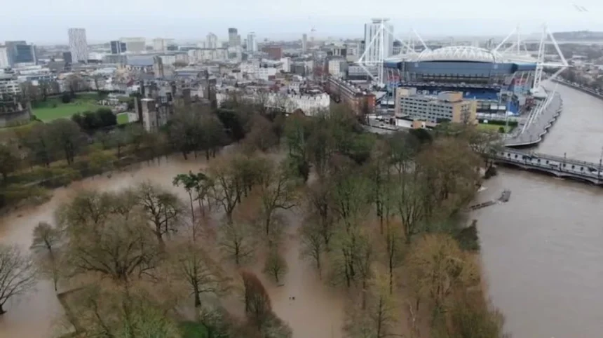
Cardiff experienced major flooding in December 1979 when the River Taff burst its banks. Canton, Pontcanna, Grangetown and Riverside were among the affected communities. The incident prompted further investment in flood protection and influenced subsequent flood-management planning.
Historical flooding provides important evidence about the city’s exposure to extreme weather.
The December 1979 incident remains a significant event in Cardiff’s flood history. A prolonged period of wet weather increased river levels before the River Taff overflowed on 27 December.
Parts of Cardiff became submerged, and thousands of homes were affected according to historical reporting. Residents required evacuation, while emergency services used boats to reach people in flooded streets.
Cowbridge Road East in Canton and Sophia Gardens in Pontcanna appeared in historical accounts of the incident.
How did the 1979 floods change Cardiff’s flood defences?
The 1979 floods demonstrated the importance of managing river levels and protecting vulnerable communities.
Subsequent flood-prevention measures included improvements to riverbanks and wider flood-management infrastructure. The construction of the Cardiff Bay Barrage also became part of the city’s longer-term approach to controlling water levels in the bay.
Sophia Gardens has a documented history of flooding, including events in 1927, the 1960s and 1979. Riverbank engineering and flood-protection improvements followed the severe 1979 incident.
What happened during the February 2020 floods?
February 2020 brought exceptional rainfall and river flows to Wales during Storms Ciara, Dennis and Jorge.
Natural Resources Wales reported flooding to 3,130 properties across Wales. The organisation described the incident as the most severe and widespread flooding experienced in Wales since 1979.
The events highlighted the importance of catchment management, flood forecasting, emergency response and effective flood defences.
Cardiff’s river systems and surrounding transport infrastructure also require monitoring during periods of extreme rainfall.
Historical flood events demonstrate why residents should use both recorded flood information and forward-looking risk assessments. Previous flooding provides useful evidence, but changes in buildings, drainage and flood defences influence present-day conditions.
How many Cardiff properties are at risk of flooding?
A 2025 Cardiff Partnership report, using 2024 Natural Resources Wales figures, identifies approximately 17,700 residential properties at risk from rivers, 7,600 from surface water and 12,700 from the sea. These figures describe separate flood-risk sources.
The figures demonstrate that flood exposure extends beyond properties immediately beside rivers.
The 2024 statistics reported in the Cardiff Partnership’s 2025 assessment provide an important overview:
- River flooding: Approximately 17,700 residential properties.
- Surface water flooding: Approximately 7,600 residential properties.
- Sea flooding: Approximately 12,700 residential properties.
These figures should not be added together to calculate a unique total of affected properties. A single property can appear in more than one flood-risk category.
The figures also describe properties identified as being at risk, not homes that experience flooding every year.
What do the flood-risk categories mean?
Natural Resources Wales uses annual probability categories to communicate river and surface water flood risk.
These categories describe the statistical chance of flooding in any individual year. A 1-in-100 annual probability does not mean flooding happens exactly once every 100 years.
A property with a 1-in-100 annual flood probability has a 1% chance of experiencing that event in any given year.
Flood probability also differs from flood depth and potential damage. A lower-probability event can still produce serious consequences.
Why do flood-risk figures matter to homeowners?
Flood statistics help residents understand the scale of the city’s exposure.
They also provide useful information for property purchases, insurance discussions, renovation decisions and household emergency planning.
However, citywide figures do not replace individual property assessments. Homeowners should examine the exact postcode and property location using official mapping tools.
How can Cardiff residents check whether their property is in a flood-risk area?
Residents can check property-level flood exposure through the Natural Resources Wales Flood Risk Assessment Wales map. The service provides postcode searches and separate information about river, sea, surface water and reservoir flooding, alongside flood defences and recorded incidents.
The official flood-risk map is one of the most useful resources for Cardiff homeowners, tenants, landlords and prospective buyers.
The Natural Resources Wales mapping service allows users to search by postcode and examine the flood-risk information surrounding a property.
Residents should follow these steps:
- Visit the Natural Resources Wales flood-risk mapping service.
- Search using the property’s postcode or location.
- Select the relevant flood source, including rivers, sea or surface water.
- Examine the risk category displayed for the property.
- Check nearby flood defences and recorded flood extents.
- Review the information for surrounding streets and waterways.
The map also provides information about reservoir flooding and areas benefiting from flood defences.
What is the difference between a flood-risk map and a planning flood map?
Natural Resources Wales provides different mapping services for different purposes.
The Flood Risk Assessment Wales map helps residents understand their exposure to flooding. It includes information about flood sources, recorded flooding and flood warnings.
The Flood Map for Planning supports planning and development decisions. Developers and property professionals use the appropriate planning information when preparing Flood Consequences Assessments.
The Flood Risk Assessment Wales map does not have official status for planning purposes. Residents and developers should not use it as a substitute for the planning flood map.
Why should residents check recorded flood incidents?
Recorded flood extents provide historical information about locations where flooding has previously occurred.
NRW explains that its records depend on whether flooding was reported, investigated and documented with sufficient confidence.
An area without recorded flooding is not necessarily free from flood risk. Similarly, a previously flooded location does not automatically experience the same flooding conditions in the future.
Residents should combine historical records with current flood-risk assessments and local knowledge.
How do Cardiff’s flood defences protect residential areas?
Cardiff’s flood defences reduce exposure through river engineering, controlled water levels, floodplains and drainage improvements. Important measures include the Cardiff Bay Barrage, engineered riverbanks and green spaces designed to temporarily accommodate excess water during periods of elevated river levels.
Flood protection in Cardiff involves several organisations and types of infrastructure.
The objective is to reduce the likelihood and consequences of flooding rather than guarantee complete protection from every possible flood event.
What does the Cardiff Bay Barrage do?
The Cardiff Bay Barrage is a major water-management structure situated across the mouth of Cardiff Bay.
It separates the freshwater environment of the bay from the tidal waters of the Severn Estuary. Its operation helps regulate water levels within the bay.
The barrage also forms an important part of Cardiff’s flood-prevention infrastructure.
However, it does not protect every Cardiff neighbourhood against river flooding, surface water accumulation or every coastal flood scenario.
How do floodplains reduce river flooding?
Floodplains are areas of land that naturally accommodate excess water when rivers rise.
Cardiff Council identifies green open spaces designed to flood temporarily as part of the city’s flood-prevention measures.
These areas provide additional capacity for river water and reduce pressure on surrounding locations.
Allowing designated open spaces to accommodate floodwater helps protect nearby built-up areas. However, residents should still follow flood warnings when river levels rise.
How do riverbank improvements help?
Engineered riverbanks provide additional protection by improving the capacity of river channels and reducing the possibility of water spilling into surrounding streets.
Historical flood protection works around Sophia Gardens and the River Taff illustrate how Cardiff has responded to previous flood events.
Maintaining these structures is important. Flood defences require inspection, maintenance and continued investment to remain effective.
What is the role of sustainable drainage?
Sustainable Drainage Systems, commonly known as SuDS, manage rainwater closer to where it falls.
Examples include:
- Permeable paving that allows water to enter the ground.
- Rain gardens that collect and temporarily store rainfall.
- Swales that transport and filter surface water.
- Attenuation ponds that hold excess runoff before controlled release.
These systems reduce pressure on conventional drainage infrastructure and support better management of urban rainfall.
Cardiff Council provides information about SuDS and its local flood-management responsibilities through its official flood and coastal erosion service.
How can residents prepare their homes for flooding?
Cardiff residents can reduce household flood damage by checking local warnings, preparing emergency supplies, protecting important documents, maintaining drainage and arranging suitable insurance. Properties in identified flood-risk areas benefit from advance planning and practical flood-protection equipment.
Household preparation is important because flooding develops through different mechanisms and can affect homes with limited warning.
Residents should prepare before severe weather arrives rather than wait until floodwater reaches their street.
What should homeowners do before flooding happens?
Residents should identify possible entry points for floodwater, including doors, airbricks, garages and low-level openings.
Practical preparation includes:
- Keeping important documents in waterproof storage.
- Moving valuable belongings away from ground-floor areas.
- Preparing a household emergency bag.
- Keeping a torch, batteries and essential medication accessible.
- Arranging suitable sandbags or flood barriers.
- Checking gutters, gullies and nearby drainage channels.
- Recording insurance details and emergency contact numbers.
Homeowners should also consider installing non-return valves where appropriate. These devices help prevent wastewater from travelling backwards through drainage pipes.
A professional drainage specialist should assess the suitability of any permanent protection equipment.
What should tenants do?
Tenants should understand the flood history and drainage conditions around their rental property.
They should report leaking pipes, blocked drains, damaged gutters and other drainage problems to their landlord or property manager.
Tenants should also establish who is responsible for emergency repairs and understand the insurance arrangements covering their personal belongings.
Residents should keep a record of valuable possessions and retain photographs of important household items.
How should households protect electrical systems?
Electrical safety becomes particularly important when floodwater approaches a property.
Residents should identify the location of their electricity supply controls and gas shut-off points before an emergency.
Never touch electrical equipment while standing in floodwater. Residents should not enter flooded buildings where electrical systems remain energised.
If it is safe to do so, arrange for a qualified professional to isolate or inspect affected electrical installations.
What insurance should Cardiff homeowners consider?
Homeowners and tenants should review their insurance policies to understand the protection available for flooding.
Buildings insurance generally covers the structure of an insured property, while contents insurance covers household belongings.
The precise cover depends on the policy wording, exclusions and individual circumstances.
Residents should disclose relevant property information accurately when obtaining insurance quotations. Previous flood claims and known flood exposure are important considerations.
What should residents do during a flood warning in Cardiff?
Residents should follow Natural Resources Wales flood warnings, monitor Met Office weather information and follow emergency instructions. People facing immediate danger must call 999. Residents should avoid flooded roads, stay away from rivers and move to safer ground when instructed.
Flood warnings provide important information about developing conditions and the actions residents need to take.
Natural Resources Wales operates a free flood-warning service for eligible locations across Wales.
Residents can register to receive warnings and alerts for locations covered by the service.
What are the different flood-warning stages?
Natural Resources Wales communicates flood information through warning categories.
- Flood alert: Flooding is possible. Residents should remain aware of developing conditions and prepare for further warnings.
- Flood warning: Flooding is expected. Residents should take immediate action to protect themselves and their property.
- Severe flood warning: There is a danger to life. Residents should follow emergency instructions and contact emergency services when necessary.
Residents should not wait for a warning before taking action if floodwater is already threatening their safety.
Which roads and locations should residents avoid?
Floodwater creates hazards for drivers, pedestrians and cyclists.
Residents should avoid driving through water-covered roads because depth, current strength and road damage are difficult to judge.
Underpasses, low-lying streets and river crossings require particular attention during heavy rainfall.
Floodwater also carries debris and contaminants. People should never walk or drive through moving floodwater.
What should residents do if water enters their property?
Residents should prioritise personal safety rather than attempting to protect possessions.
They should move upstairs or towards higher ground when necessary and follow emergency-service instructions.
Do not attempt to remove heavy furniture or electrical appliances through floodwater.
After the immediate danger has passed, residents should contact their insurer, document damage and arrange a safe inspection before returning to affected rooms.
Which organisations manage flood risks in Cardiff?
Cardiff Council, Natural Resources Wales, Dŵr Cymru Welsh Water and Transport Wales-related road authorities have different responsibilities for flood management. Their work covers river and coastal warnings, local drainage, sewer infrastructure, road flooding, emergency response and flood-prevention planning.
Residents should contact the correct organisation according to the source of flooding.
What is Cardiff Council responsible for?
Cardiff Council acts as the Lead Local Flood Authority.
Its responsibilities include managing local flood risk from ordinary watercourses, surface runoff and groundwater through relevant statutory duties and local flood-management planning.
The council also maintains highway drainage and investigates certain local flooding problems.
Its Local Flood Risk Management Strategy and Flood Risk Management Plan explain its approach to managing local flood exposure.
What does Natural Resources Wales do?
Natural Resources Wales manages flood warnings and provides information about river and coastal flood risks.
It operates the Flood Risk Assessment Wales mapping service and provides information about recorded flooding, flood defences and flood-warning areas.
Residents can also report river and coastal flooding directly to NRW.
Contact: 0300 065 3000.
What does Dŵr Cymru Welsh Water do?
Dŵr Cymru Welsh Water manages public water and sewerage services in its operating area.
Residents should contact the organisation when flooding originates from water mains or public sewers.
Private drainage problems and surface water flooding require different reporting routes.
Contact: 0800 085 3968.
Who should residents contact about flooded roads?
Cardiff Council manages local highway drainage and receives reports about blocked drains, road flooding and surface water problems.
For motorway and trunk-road incidents, residents should contact Traffic Wales.
Traffic Wales: 0300 123 1213.
For immediate danger to life, call 999.
Explore More Area Guide
Things to Do in Cardiff With Teenagers: Best Activities and Attractions
Cardiff Libraries for Children: Books, Storytime and Activities
How will climate change affect flood risk in Cardiff?
Climate change increases long-term flood-management challenges through rising sea levels, changing rainfall patterns and more intense rainfall events. Cardiff’s river catchments, coastal communities and urban drainage systems require continued investment, monitoring and adaptation to manage future flood exposure.
Climate change is an important consideration for Cardiff’s long-term flood planning.
More intense rainfall places additional pressure on rivers, drainage systems and watercourses. When rainfall occurs across already saturated catchments, runoff increases and river levels rise.
Sea-level rise also creates challenges for coastal communities. Areas near the Severn Estuary require continued assessment of tidal conditions, coastal defences and future water levels.
Which Cardiff locations require continued monitoring?
The southern communities of Cardiff deserve particular attention because of their exposure to river and coastal flood risks.
Grangetown and Butetown feature prominently in coastal flood-risk assessments. Canton and Riverside have important historical and geographical connections with the River Taff.
Eastern communities within the River Rhymney catchment also require ongoing flood-risk assessment.
However, future exposure depends on local topography, infrastructure, land development and the effectiveness of flood defences.
Why is long-term flood planning important?
Cardiff Council’s Local Flood Risk Management Strategy provides a framework for identifying local flood hazards and prioritising preventative action.
Natural Resources Wales also contributes through national flood-risk assessments, warning services and flood-management programmes.
Continued investment in drainage infrastructure, flood storage, river maintenance and sustainable urban development supports the city’s resilience.
Property owners also have an important role. Maintaining household drainage, understanding insurance requirements and following official warnings contribute to wider community preparedness.
What should Cardiff residents remember about flood-prone areas?
Cardiff’s flood risk varies between neighbourhoods and individual properties. Canton, Riverside, Grangetown, Roath, Whitchurch and Butetown feature prominently in official risk assessments. Residents should check postcode-level maps, register for warnings and prepare their homes.
Flooding is an important consideration for Cardiff residents, homeowners, tenants, landlords and property buyers.
The River Taff, River Ely and River Rhymney influence the city’s river flood exposure. Cardiff Bay and the Bristol Channel create additional coastal considerations, while heavy rainfall places pressure on urban drainage networks.
The December 1979 floods demonstrate the historical consequences of river flooding in Cardiff. More recent national flooding events, including February 2020, reinforce the importance of effective flood protection and emergency preparedness.
Residents should take five practical steps:
- Check their property’s flood exposure using the Natural Resources Wales flood-risk map.
- Review historical flooding information and nearby flood defences.
- Register for relevant Natural Resources Wales flood warnings.
- Prepare household emergency supplies and suitable property protection.
- Understand which organisation to contact when flooding occurs.
Accurate flood information helps residents make informed decisions about housing, insurance, home improvements and emergency planning. Continued cooperation between Cardiff Council, Natural Resources Wales, Welsh Water and local communities remains essential to managing the city’s flood risks.
Which areas of Cardiff are most at risk of flooding?
Canton, Riverside, Grangetown, Roath, Whitchurch and Butetown feature prominently in Cardiff’s flood-risk assessments. Their exposure varies according to river proximity, coastal conditions, elevation and local drainage infrastructure.