
Cardiff Bay is one of the most significant waterfront areas in Wales. It combines maritime history, regenerated docklands, cultural landmarks, public spaces and a long network of walking paths.
- What is the Cardiff Bay Walking Route?
- How did Cardiff Bay develop into a walking destination?
- Which landmarks are included on the Cardiff Bay Walking Route?
- Mermaid Quay
- Wales Millennium Centre
- Senedd
- Norwegian Church
- Cardiff Bay Barrage
- Pont y Werin
- International Sports Village
- How long does the Cardiff Bay Walking Route take?
- Is the Cardiff Bay Walking Route accessible?
- How can visitors reach the Cardiff Bay Walking Route?
- What should visitors know before walking around Cardiff Bay?
- Why is the Cardiff Bay Walking Route important for Cardiff?
The official Cardiff Bay Trail is approximately 10km (6.2 miles) and forms a circular route connecting Cardiff Bay with Penarth through the Barrage and Pont y Werin. The trail is designed for walkers and cyclists and passes landmarks including the Norwegian Church, Wales Millennium Centre and Senedd.
The route is predominantly flat and follows waterfront promenades, public paths and road-linked sections. The Cardiff Bay Barrage provides a particularly open section with views across the Bay and Severn Estuary. Its embankment has a flat gradient and no steps.
For visitors, the Cardiff Bay Walking Route provides a practical way to understand how Cardiff’s historic port developed into a major cultural and leisure destination.
What is the Cardiff Bay Walking Route?
Cardiff Bay Walking Route is a circular 10km trail linking Cardiff waterfront landmarks, the Barrage, Penarth Marina and Pont y Werin. It combines industrial heritage, cultural buildings, open waterfront spaces and accessible paths, providing a way to explore Cardiff Bay.
The official Cardiff Bay Trail covers approximately 10km or 6.2 miles. It crosses Cardiff Bay, passes over the Cardiff Bay Barrage and continues towards Penarth before returning through Pont y Werin. The route serves both pedestrians and cyclists.
The route is not simply a promenade beside the water. It connects several distinct parts of the Cardiff Bay waterfront. These include Mermaid Quay, Roald Dahl Plass, the Wales Millennium Centre, the Senedd, the Norwegian Church, Cardiff International Sports Village, Penarth Marina and the Barrage.
The walking experience changes along the route. The central waterfront contains restaurants, cafés, cultural venues and major architectural landmarks. The Barrage provides a more open environment with extensive views across the water.
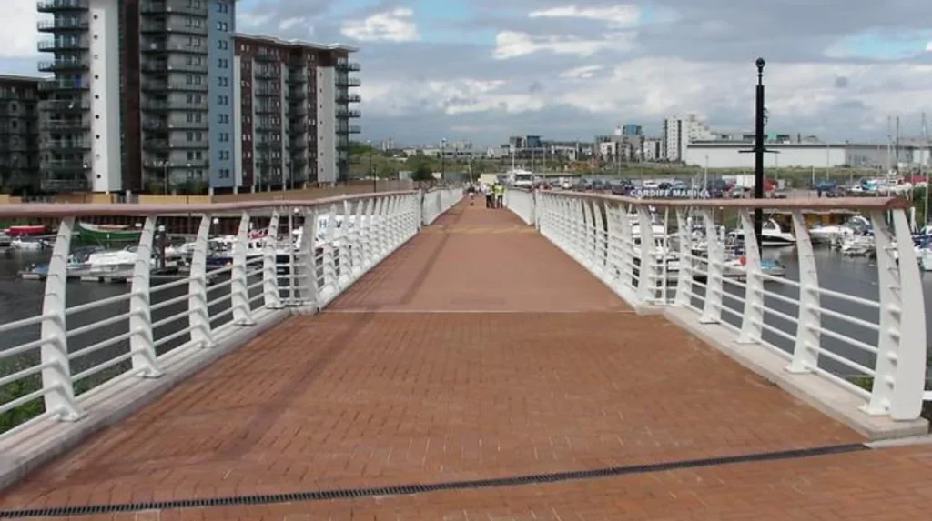
The trail also demonstrates the relationship between Cardiff and Penarth. Pont y Werin is a 140-metre pedestrian and cycle bridge connecting the International Sports Village with Penarth.
This makes the route useful for visitors who want one continuous walk rather than separate short walks around individual attractions.
How did Cardiff Bay develop into a walking destination?
The Cardiff Bay route developed from industrial dockland into a regenerated waterfront. Coal exports shaped the area during the nineteenth and early twentieth centuries, while the 1999 Barrage transformed the tidal estuary into a 220-hectare freshwater lake and supported regeneration.
Cardiff Bay’s modern landscape is closely connected with the city’s industrial history. During the nineteenth century, Cardiff became a major coal-exporting port. The growth of the coal trade led to the construction of successive docks.
Bute West Dock opened in 1839. Bute East Dock followed in 1855, Roath Basin in 1874, Roath Dock in 1887, and Queen Alexandra Dock in 1907. These developments created an extensive industrial waterfront.
The docklands also became home to an internationally diverse population. The area around Butetown became known as Tiger Bay, with people from many countries working in maritime and dock-related industries. Cardiff Harbour Authority records estimate that at least 50 nationalities settled in the area.
Cardiff’s coal trade reached a major peak before the First World War. In 1913, exports exceeded 13 million tonnes. The Coal Exchange also became an important commercial institution where international coal prices were negotiated.
The economic role of the docks declined after the Second World War. International coal demand fell, containerisation changed port operations and Cardiff’s traditional coal trade weakened. By the 1960s, coal exports had virtually ceased.
The decline created significant social and economic problems in the surrounding docklands. In 1987, the Cardiff Bay Development Corporation was established to regenerate approximately 1,100 hectares of old docklands in Cardiff and Penarth.
A major part of the transformation was the Cardiff Bay Barrage. Construction began in 1994, and the project was completed in 1999 at a reported cost of £220 million. The Barrage created the modern freshwater Bay and helped support approximately £2 billion of regeneration in the old dockland areas of Cardiff and Penarth.
This history explains why the walking route contains such different environments. Historic dock buildings sit close to modern cultural architecture, public squares, marinas and engineered waterfront infrastructure.
Which landmarks are included on the Cardiff Bay Walking Route?
The Cardiff Bay Trail forms a full 10km circular route through Cardiff Bay, across the Barrage and into Penarth. Key sections include Mermaid Quay, the Senedd, Wales Millennium Centre, Norwegian Church, International Sports Village, Pont y Werin and the Barrage.
The central Cardiff Bay section contains the greatest concentration of recognised landmarks.
Mermaid Quay
Mermaid Quay is a major waterfront leisure and commercial area. It contains restaurants, cafés, shops and public spaces beside the water. It provides a practical starting point for visitors because several transport services and car parks serve the surrounding area.
Wales Millennium Centre
The Wales Millennium Centre is a major performing arts venue on Cardiff Bay. Its distinctive architecture makes it one of the most recognisable buildings on the waterfront. The building sits beside Roald Dahl Plass and forms an important cultural landmark on the walking route.
Senedd
The Senedd is the building of the Welsh Parliament. It stands beside the waterfront near the Wales Millennium Centre. Its transparent architectural design provides a prominent contrast with Cardiff Bay’s older industrial buildings.
Norwegian Church
The Norwegian Church is an important reminder of Cardiff’s maritime connections. Norwegian sailors and communities had strong links with Cardiff’s port. The church now forms part of the Bay’s cultural landscape and is specifically identified as a historic landmark on the official Cardiff Bay Trail.
Cardiff Bay Barrage
The Barrage is one of the route’s most important engineering landmarks. It extends for approximately 1.1km between Cardiff docks and Penarth. The structure contains locks, bridges, sluice gates and a fish pass.
The Barrage also provides a public promenade and landscaped open space. Walkers can cross the structure while viewing Cardiff Bay on one side and the Severn Estuary on the other.
Pont y Werin
Pont y Werin provides the pedestrian and cycle connection between Cardiff and Penarth. Its 140-metre span is an important part of the circular Cardiff Bay Trail.
International Sports Village
The International Sports Village forms another major part of the southern Cardiff Bay landscape. It is connected to the wider walking and cycling network and provides a different environment from the historic central waterfront.
Together, these landmarks give the route strong historical, cultural, architectural and recreational relevance.

How long does the Cardiff Bay Walking Route take?
Most walkers complete the Cardiff Bay Walking Route in two to three hours at a sightseeing pace. Allow time for landmark stops, photographs, cafés and museums. The flat waterfront layout supports a straightforward walk without sustained climbs or mountain terrain.
Walking time depends on the purpose of the visit. A person walking continuously at a moderate pace completes 10km considerably faster than someone stopping frequently at attractions.
A two-hour walk requires an average speed of approximately 5km per hour. A three-hour visit requires an average of approximately 3.3km per hour. Visitors who spend time inside cultural venues, stop for food or take photographs need additional time.
The route is best treated as a half-day visitor activity when combined with attractions.
A practical walking sequence begins around Mermaid Quay and the central Bay. From there, walkers can continue past the Wales Millennium Centre and Senedd before heading towards the Norwegian Church and wider waterfront.
The route then continues towards the Barrage. The Barrage section provides a long, open pedestrian environment. From the Barrage, the trail continues towards Penarth and Pont y Werin before returning towards the Cardiff Bay area.
The official route distance is the most useful planning measurement because it provides a consistent framework regardless of walking speed.
The Barrage itself is approximately 1.1km long, making it a substantial individual section of the wider route.
Visitors should also distinguish between the 10km Cardiff Bay Trail and shorter waterfront walks. A person walking only around Mermaid Quay, Roald Dahl Plass and the Senedd does not complete the full circular trail.
Is the Cardiff Bay Walking Route accessible?
Cardiff Bay Walking Route suits many visitors because much of the trail uses level waterfront paths, promenades and accessible public spaces. The Barrage embankment has a flat gradient and no steps, while route conditions require attention to works and diversions.
The Barrage is particularly suitable for visitors seeking a level walking environment. Cardiff Harbour Authority states that its embankment has a flat gradient and no steps.
The wider trail includes different surfaces and environments, so accessibility should be assessed across the complete route rather than only the Barrage.
The route contains waterfront promenades, shared pedestrian and cycling areas, bridges and sections close to roads. People using wheelchairs, mobility aids or pushchairs should check current route information before setting out.
Temporary construction works can affect individual sections. Cardiff Harbour Authority has previously introduced signed diversions when parts of the trail were closed for regeneration works. A 2024 diversion near Jim Driscoll Way demonstrates why visitors should follow current on-site signage rather than rely entirely on older route descriptions.
The Barrage provides an especially useful section for people who want a short, flat waterfront walk without committing to the full 10km circuit.
The Bay also contains public seating, hospitality venues and transport connections. These features allow visitors to divide the wider walk into shorter sections.
Cyclists also use significant parts of the trail. Pedestrians should remain aware of shared paths and give sufficient space to other users.
Accessibility therefore depends on both the physical route and current conditions. The flat character of Cardiff Bay remains one of its strongest advantages for everyday walking.
How can visitors reach the Cardiff Bay Walking Route?
Visitors can reach Cardiff Bay by train, bus, car, bicycle or on foot from central Cardiff. Cardiff Bay station provides a connection, while baycar service 6 links St Mary Street with Wales Millennium Centre. Several car parks serve waterfront destinations.
Public transport provides several ways to start the walk.
Cardiff Bay station is connected to Cardiff Queen Street station by Transport for Wales services. This provides a direct rail option from the city centre.
The baycar service 6 provides a direct bus connection between St Mary Street in central Cardiff and the Wales Millennium Centre via Lloyd George Avenue. Other bus services also serve Mermaid Quay, the Wales Millennium Centre and the International Sports Village.
Visitors arriving by car have several parking options around Cardiff Bay. Cardiff Harbour Authority lists parking at locations including the Barrage, Havannah Street, Stuart Street, Harbour Drive and Pierhead Street.
Cycling is also practical because Cardiff Bay forms part of Cardiff’s wider active-travel network. The Cardiff Bay Trail itself is designed for both walkers and cyclists.
Walking from central Cardiff is another option. Visit Cardiff describes the recreational waterfront as being within a short walking distance of the city centre.
The choice of starting point affects the walking experience. Mermaid Quay and the Wales Millennium Centre provide access to the cultural centre of the Bay. The Barrage provides direct access to the open waterfront and the Penarth side of the circular route.
For visitors using public transport, starting in central Cardiff and travelling to the Bay by train or bus avoids the need to arrange parking.
Explore More Area Guide
Temple of Peace Cardiff: History, Heritage and Peace 2026
Coal Exchange History: Cardiff Industrial Landmark | Cardiff 2026
What should visitors know before walking around Cardiff Bay?
Walking Cardiff Bay requires attention to water edges, traffic, cyclists, route conditions and construction diversions. Swimming in the Bay is prohibited because of drowning risks. Staying on paths and following Harbour Authority signs keeps the route with safety guidance.
Water safety is particularly important around Cardiff Bay. Cardiff Harbour Authority states that swimming and jumping into the Bay are not permitted because of drowning risks. The water has unpredictable depths and hidden objects, while boats also operate in the area.
The Bay is a freshwater environment created by the Barrage and replenished by the rivers Taff and Ely. The modern Bay covers approximately 220 hectares.
Visitors should remain on designated public walking areas and avoid entering restricted operational zones around the Barrage.
The Barrage contains active marine infrastructure. Its locks allow vessels to move between Cardiff Bay and the Severn Estuary. The structure includes three locks, each approximately 40 metres long. Two are 8 metres wide and one is 10.5 metres wide.
The Barrage also contains five sluice gates that regulate water levels. Each sluice is 7.5 metres high and 9 metres wide, with each gate capable of handling more than a quarter of a million litres of water per second.
These engineering systems explain why visitors should follow barriers, signs and instructions around operational areas.
The Barrage also includes a fish pass. It supports salmon and sea trout movement between the rivers Taff and Ely and the wider estuary system. Cardiff Harbour Authority monitors the facility using equipment that records fish movement and identifies species.
Cycling is another consideration. The trail is shared with cyclists, so walkers should maintain awareness on narrower or busy sections.
Weather also affects waterfront walking. Strong winds can make exposed sections uncomfortable, particularly across the Barrage and other open waterfront areas. Comfortable footwear and suitable clothing are practical for the full-distance route.
Current route information is also important. Regeneration projects can produce temporary closures or diversions. Visitors should follow current signs and Cardiff Harbour Authority notices when conditions differ from older maps.
Why is the Cardiff Bay Walking Route important for Cardiff?
The Cardiff Bay Walking Route connects Cardiff’s industrial history, modern regeneration, cultural institutions, maritime infrastructure and public waterfront. Its 10km circular structure creates a continuous visitor route linking Cardiff, Penarth, historic landmarks, cultural venues and major engineered landscapes.
The route has significance beyond recreation because it physically connects different stages of Cardiff’s development.
The historic docklands explain Cardiff’s nineteenth-century growth as an international coal port. The modern Bay demonstrates the city’s transition towards cultural, residential, leisure and service-based waterfront activity.
The 1999 Barrage represents the central engineering intervention behind the modern Bay. Cardiff Harbour Authority describes the project as the catalyst for approximately £2 billion of regeneration across the old dockland areas of Cardiff and Penarth.
The waterfront now contains major cultural institutions. The Wales Millennium Centre and Senedd provide nationally significant cultural and civic functions, while the Norwegian Church preserves part of the area’s maritime heritage.
The route also connects Cardiff with Penarth through Pont y Werin. This makes the trail geographically broader than a central Cardiff waterfront promenade.
The Cardiff Bay Barrage has become another major public destination. Cardiff Harbour Authority states that more than one million people visit the Barrage each year, demonstrating its importance as a public waterfront space.
The route therefore provides several layers of information in one continuous journey. Visitors can observe industrial heritage, urban regeneration, civic architecture, performing arts, maritime infrastructure, environmental management and active travel.
Its long-term relevance also comes from its role in connecting public spaces. Walking requires no specialist equipment, and the flat waterfront environment allows the route to function as both a visitor attraction and an everyday recreational corridor.
The Cardiff Bay Walking Route is consequently an important part of Cardiff’s wider visitor infrastructure. It links major attractions while preserving access to the waterfront itself.
For visitors researching Cardiff on foot, the 10km circular trail provides a clear framework for exploring the Bay without treating each landmark as an isolated destination. Its combination of history, architecture, engineering, culture and waterfront space makes it one of the city’s most comprehensive urban walking routes.
How long is the Cardiff Bay Walking Route?
The official Cardiff Bay Trail is approximately 10km (6.2 miles) long. It forms a circular route connecting Cardiff Bay, the Cardiff Bay Barrage, Penarth and Pont y Werin.