The River Ely is one of the three principal rivers flowing through Cardiff, Wales. It connects the South Wales valleys with the western districts of Cardiff, passes through communities including St Fagans and Ely, and reaches Cardiff Bay before entering the Severn Estuary. The river has shaped the area’s geography, industrial development, natural habitats and local communities.
- What is the River Ely and where is it located?
- Where does the River Ely start and where does it end?
- What is the history of the River Ely in Cardiff?
- Which tributaries flow into the River Ely?
- What is the connection between the River Ely and Cardiff Bay?
- How does the Cardiff Bay Barrage work?
- What is the River Ely’s relationship with Penarth Marina?
- Can boats use the River Ely?
- What wildlife lives in and around the River Ely?
- Which fish species live in the River Ely?
- Why are salmon and sea trout important?
- Why are riverside habitats important?
- What is the water quality of the River Ely?
- What caused pollution in the River Ely?
- Has the River Ely become cleaner?
- How is water quality monitored in Cardiff Bay?
- Why does the River Ely experience flooding?
- Which areas have experienced River Ely flooding?
- How do bridges increase flood risk?
- How is flooding managed along the River Ely?
- What flood defences protect communities along the River Ely?
- What is the Ely Bridge Flood Risk Management Scheme?
- What role does Cardiff Council play?
- How can residents monitor flood warnings?
- Where can visitors walk and explore the River Ely?
- Exploring the river near St Fagans
- Exploring Ely and western Cardiff
- Exploring the lower river near Penarth Marina
- What environmental restoration projects are improving the River Ely catchment?
- What is the Nant Dowlais restoration project?
- Why is reconnecting rivers with floodplains important?
- How does fish passage support restoration?
- How does climate change affect the River Ely and Cardiff?
- How can heavier rainfall increase flooding?
- How can rising temperatures affect river wildlife?
- Why is long-term river management important?
- Why is the River Ely important to Cardiff’s future?
The River Ely is important to Cardiff’s environmental management, flood protection, biodiversity and recreational landscape. Its catchment extends beyond the city boundary into Rhondda Cynon Taf and the Vale of Glamorgan. The river also connects Cardiff’s urban environment with the wider South Wales river network.
Understanding the River Ely requires examining its source, geographical route, historical development, tributaries, wildlife, water quality, flood risks and relationship with Cardiff Bay. These features explain why the river remains an important part of Cardiff’s natural and built environment.
What is the River Ely and where is it located?
The River Ely is a major river in South Wales that flows through the western side of Cardiff before reaching Cardiff Bay and the Severn Estuary. It connects inland valleys with the coast and supports urban communities, wildlife habitats and important drainage systems.
The River Ely is one of Cardiff’s three principal rivers, alongside the River Taff and River Rhymney. It forms part of the South East Valleys river catchment system, which drains water from the upland areas towards the Bristol Channel.
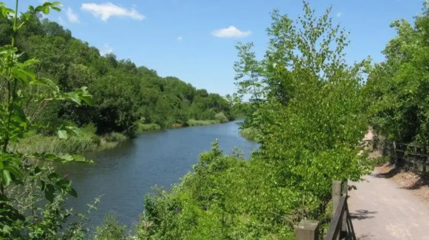
The river begins in the uplands north of Cardiff, within the wider Rhondda Cynon Taf region. Its course passes through rural landscapes before entering the Cardiff urban area. St Fagans, Ely and surrounding western Cardiff communities are among the locations associated with its route.
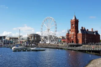
The river eventually reaches Cardiff Bay. Its lower course is influenced by the Cardiff Bay Barrage, an engineering structure that transformed the former tidal docklands into a freshwater-controlled waterfront environment.
The River Ely performs several important geographical functions. It transports rainfall and surface water downstream, supports riverside habitats and forms part of Cardiff’s wider flood-management network.
Cardiff Council identifies the Ely, Taff and Rhymney as the city’s principal river catchments. These catchments influence drainage patterns, development planning and flood-risk management across the county.
Where does the River Ely start and where does it end?
The River Ely rises in the upland landscape north of Cardiff, within the wider South Wales valleys, and flows south towards Cardiff Bay. It passes through St Fagans and Ely before reaching the coastal waters connected to the Severn Estuary.
The river’s upper catchment collects rainfall from the surrounding hills and valleys. Smaller streams and tributaries contribute water as the main channel moves towards the lowlands.
The River Ely gradually changes character along its route. Its upper reaches are associated with rural landscapes and smaller settlements. Further downstream, the river passes through increasingly developed areas.
The upper reaches
The upper River Ely catchment lies within the South Wales uplands. Rainfall from surrounding slopes enters streams and drainage channels that feed the river system.
The surrounding landscape includes agricultural land, hillsides and established settlements. Water movement in this section responds to rainfall, soil conditions and the steepness of the terrain.
The middle reaches
The middle section passes through areas associated with the communities surrounding St Fagans and Ely.
The landscape becomes increasingly urban as the river approaches Cardiff. Bridges, roads, riverside vegetation and residential development influence the character of its channel.
St Fagans provides an important geographical reference point because the river passes close to the historic settlement and its surrounding landscape.
The lower reaches
The lower River Ely approaches the coastal environment through the western side of Cardiff and the Ely estuary.
Its final section connects with Cardiff Bay, where the barrage controls water levels within the bay. The wider estuarine environment forms part of the Severn Estuary system.
The Severn Estuary is an internationally important coastal environment recognised for its ecological significance. Its tidal conditions and habitats influence the wider coastal landscape around Cardiff.
What is the history of the River Ely in Cardiff?
The River Ely has a long industrial history connected with coal mining, metal production, paper manufacturing and transport in South Wales. Victorian industrial expansion increased pollution, while river engineering altered natural channels and affected habitats throughout its catchment.
The River Ely played an important role in the industrial development of South Wales. Its location connected inland industrial settlements with Cardiff’s coastal trading network.
During the 19th century, the surrounding region experienced significant industrial expansion. Coal mining, metalworking and manufacturing activities increased around the river catchment.
How did Victorian industry affect the river?
Industrial development placed considerable pressure on the River Ely. Factories, mines and settlements discharged waste into watercourses, while expanding populations increased sewage pollution.
The river became associated with severe industrial contamination. Waste from coal, metal and paper industries affected water quality and damaged aquatic habitats.
According to Afonydd Cymru, the River Ely was historically one of South Wales’ heavily polluted industrial rivers. Its condition gradually improved as heavy industry declined and environmental regulation developed. Afonydd Cymru+1
How did transport and trade influence the Ely estuary?
The lower River Ely and its estuary became closely connected with Cardiff’s maritime economy.
The development of docks and railway infrastructure transformed the surrounding waterfront. Penarth Dock, located beside the Ely estuary, opened in 1865. The Taff Vale Railway promoted the dock to support coal exports and maritime trade.
The dock expanded in 1884 as commercial activity developed. It eventually closed in 1963 following the decline of traditional dock operations.
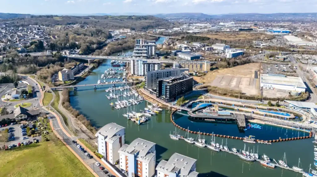
The former dock site subsequently became Penarth Marina. The modern marina preserves part of the area’s maritime character while supporting recreational boating and waterfront development. Coflein+1
The history of the River Ely therefore reflects the wider transformation of South Wales from an industrial economy towards a more diversified urban and service-based region.
Which tributaries flow into the River Ely?
The River Ely receives water from several tributaries across its catchment, including the River Clun, Nant Myddlyn and other smaller streams. These watercourses collect rainfall from surrounding settlements, agricultural land and hillsides before joining the main river.
Tributaries are smaller rivers and streams that flow into a larger watercourse. They increase the volume of water carried by the main channel and connect different parts of a river catchment.
The River Ely catchment covers approximately 167–169 square kilometres, according to catchment information published by Afonydd Cymru and Rhondda Cynon Taf Council. The precise figure varies slightly between published assessments.
River Clun
The River Clun is one of the most important tributaries of the Ely. It joins the main river near Pontyclun, contributing water from the surrounding landscape.
Pontyclun is an established settlement in Rhondda Cynon Taf. The confluence connects the Clun catchment with the wider River Ely drainage network.
The River Clun also demonstrates how watercourses outside Cardiff influence river conditions within the city.
Nant Myddlyn
Nant Myddlyn is another important watercourse associated with the Ely catchment. It contributes to the drainage network serving the surrounding countryside and settlements.
Smaller streams are particularly important during periods of heavy rainfall because they transfer surface water into the main river system.
Other smaller watercourses
The catchment also contains smaller streams, drainage channels and connected watercourses.
These channels contribute to the river’s overall hydrological system. Their condition influences water quality, sediment movement and the amount of water entering the River Ely.
The catchment approach is important because pollution and flooding upstream can affect communities further downstream in Cardiff.
What is the connection between the River Ely and Cardiff Bay?
The River Ely flows into Cardiff Bay through the western side of the city, contributing freshwater to the controlled water environment. Its lower reaches connect Cardiff’s river network with the Cardiff Bay Barrage, Penarth Marina and the Severn Estuary.
Cardiff Bay is a major waterfront area created through the redevelopment of Cardiff’s former docklands. The construction of the Cardiff Bay Barrage changed the area’s tidal conditions and established a controlled freshwater environment.
The River Ely is one of the principal rivers replenishing the bay, alongside the River Taff.
How does the Cardiff Bay Barrage work?
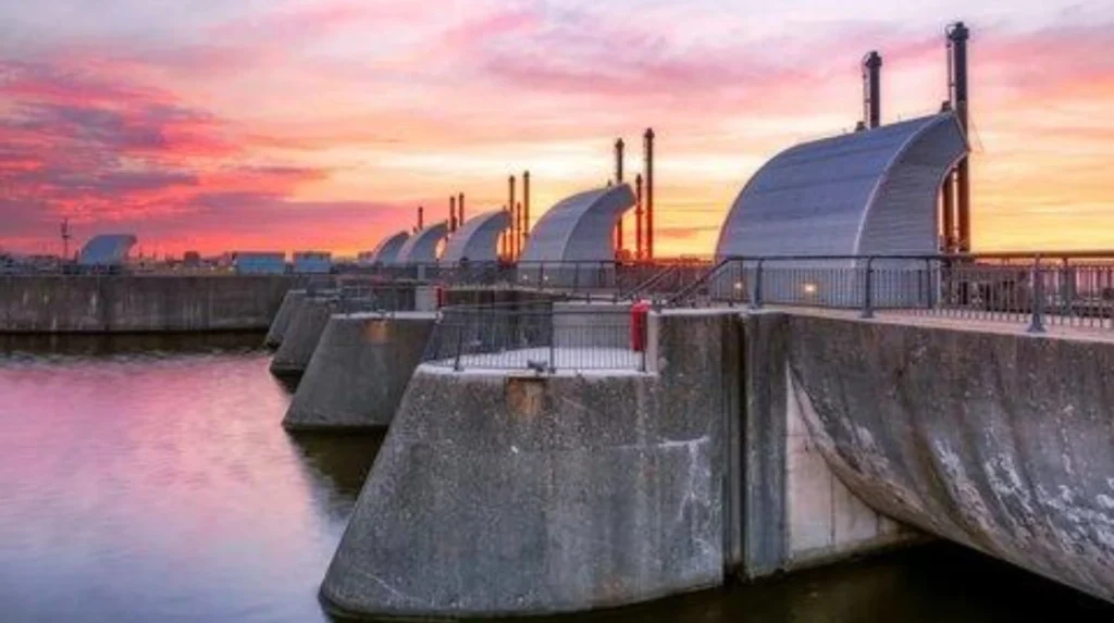
The Cardiff Bay Barrage is a major water-management structure connecting Cardiff Bay with the Severn Estuary.
It controls water movement through sluice gates and navigation locks. The structure prevents high tides from entering the bay and helps maintain its freshwater environment.
According to Cardiff Harbour Authority, the barrage contains five sluice gates. Each gate measures approximately 7.5 metres high and 9 metres wide.
The sluices release water from the River Ely and River Taff into the Bristol Channel. They also close when the estuary level exceeds the level inside Cardiff Bay.
What is the River Ely’s relationship with Penarth Marina?
Penarth Marina occupies the site of the former Penarth Dock. It sits beside the lower River Ely and provides access to Cardiff Bay.
The marina is an important recreational and maritime location. Its facilities support leisure boating, waterfront businesses and residential development.
The River Ely forms part of the wider navigation environment around the marina. Cardiff Harbour Authority manages navigation and safety within the harbour.
Can boats use the River Ely?
Yes. The River Ely forms part of Cardiff Harbour’s navigable water environment.
Cardiff Harbour Authority applies a maximum speed limit of five knots on the River Ely. Boaters must also observe bridge restrictions and navigation instructions.
Pont y Werin is a pedestrian and cycling bridge crossing the river. Its central section lifts to allow authorised vessels to pass.
The bridge connects Cardiff with the Vale of Glamorgan and provides an important active-travel route.
What wildlife lives in and around the River Ely?
The River Ely supports freshwater fish, aquatic invertebrates, riverside vegetation and birdlife. Recorded fish species include brown trout, pike, perch, roach, chub, carp, eels and grayling, alongside migratory salmon and sea trout.
The river provides different habitats along its route. These include flowing freshwater channels, gravel beds, vegetated banks and areas of slower-moving water.
The condition of these habitats influences the species that can survive in the river.
Which fish species live in the River Ely?
Afonydd Cymru identifies several fish species associated with the River Ely.
Examples include:
- Brown trout, which inhabit freshwater rivers and streams.
- Pike, a predatory freshwater fish.
- Perch, which occupy different freshwater habitats.
- Roach, a common freshwater fish.
- Chub, which live in flowing rivers.
- Carp, which occupy slower-moving water.
- European eels, which have a complex migratory lifecycle.
- Grayling, a freshwater fish associated with clean, flowing water.
- Sea trout and salmon, which migrate between freshwater and marine environments.
Barbel have also been reported in the lower reaches. Their presence adds to the diversity of fish recorded within the river system.
Why are salmon and sea trout important?
Salmon and sea trout are migratory fish. They travel between freshwater breeding habitats and marine feeding grounds.
Adult fish return to freshwater rivers to reproduce. Young fish develop before migrating downstream towards the sea.
The Cardiff Bay Barrage includes a specially designed fish pass. This structure helps migratory fish move between the Severn Estuary, Cardiff Bay and the rivers Taff and Ely.
Cardiff Harbour Authority monitors the fish pass using underwater cameras and other recording equipment. The system helps identify fish movements and supports environmental monitoring.
Why are riverside habitats important?
Vegetated riverbanks provide shelter and feeding opportunities for wildlife.
Trees and shrubs provide habitats for birds and insects. Their roots also help stabilise riverbanks and reduce erosion.
Aquatic vegetation supports small organisms and contributes to the ecological structure of freshwater environments.
Healthy river habitats also help maintain natural processes, including nutrient cycling and the movement of organic material through the watercourse.
What is the water quality of the River Ely?
The River Ely has experienced significant historical pollution from industrial activity, sewage and urban development. Although conditions improved following industrial decline, water quality and ecological pressures remain important environmental concerns requiring monitoring, pollution control and habitat restoration.
Water quality determines whether a river provides suitable conditions for aquatic organisms, wildlife and human activities.
The River Ely has experienced substantial changes in water quality over time.
What caused pollution in the River Ely?
Historical pollution came from several sources.
Industrial waste from coal mining, metal production and paper manufacturing affected the river during the industrial period.
Urban expansion introduced additional pressures through wastewater discharge, surface-water runoff and drainage infrastructure.
Modern pollution sources include wastewater treatment operations, sewer misconnections and diffuse pollution from developed land.
Diffuse pollution describes contamination entering waterways from widespread sources rather than a single identifiable discharge.
Examples include road runoff, fertilisers, sediment and chemicals washed from urban surfaces.
Has the River Ely become cleaner?
The river’s condition improved following the decline of heavy industry and changes in environmental regulation.
However, improvements do not mean that all ecological problems have disappeared.
Afonydd Cymru reported in its October 2023 assessment that the main river was failing Water Framework Directive assessments for water quality and fish. Its 2025 catchment information also highlights the continuing need for environmental improvement.
The Water Framework Directive is a European environmental framework that establishes objectives for protecting and improving the ecological and chemical condition of water bodies. Its principles continue to inform water management in Wales.
How is water quality monitored in Cardiff Bay?
Cardiff Harbour Authority monitors the environmental condition of Cardiff Bay.
Its monitoring programme measures several water-quality indicators, including:
- Dissolved oxygen, which supports aquatic organisms.
- Salinity, which measures salt concentration.
- Water temperature, which affects aquatic life.
- pH, which indicates acidity or alkalinity.
- Nutrient and metal concentrations, which help identify pollution.
The authority monitors chemical conditions at nine locations across the bay. Continuous readings are taken at 15-minute intervals.
The Cardiff Bay Barrage Act requires dissolved oxygen levels to remain above five milligrams per litre throughout the bay to protect migratory fish.
The authority also operates a predictive water-quality system that helps inform people about conditions for water-based activities.
Why does the River Ely experience flooding?
The River Ely experiences flooding when heavy rainfall increases river flows beyond the capacity of its channel and surrounding infrastructure. Flood risk is influenced by upstream rainfall, urban development, bridge blockages, drainage conditions and the river’s connection with Cardiff’s low-lying areas.
Flooding is an important environmental and infrastructure issue along the River Ely.
The river receives water from a large catchment extending beyond Cardiff. Heavy rainfall upstream increases the amount of water moving towards the city’s western communities.
When river levels rise, low-lying land and properties near the channel become more vulnerable.
Which areas have experienced River Ely flooding?
Ely Bridge and surrounding residential areas have experienced significant flooding.
Natural Resources Wales records several historical flooding incidents:
- 1927: Widespread flooding extended towards Victoria Park.
- 1960: Further widespread flooding affected areas around the river.
- September 2008: Approximately 27 properties were inundated.
- 2011: Further properties experienced flooding.
- 2012: Flooding occurred again in the affected area.
- 2020: Additional flooding affected properties around the river.
During the September 2008 event, peak river flows were estimated to be equivalent to filling an Olympic swimming pool every 20 seconds.
These incidents demonstrate the importance of managing river levels and maintaining adequate water-flow capacity. Citizen Space
How do bridges increase flood risk?
Bridges influence how much water can pass through a river channel.
The Cowbridge Road West bridge, which carries the A48 over the River Ely, has experienced problems with debris accumulation.
Large branches and trees become trapped against the bridge’s central pier. This reduces the available space for water to pass underneath the structure.
When heavy rainfall increases river flows, a partially blocked bridge increases the risk of water levels rising upstream.
Natural Resources Wales identifies bridge blockages as an important contributing factor in previous flooding incidents.
How is flooding managed along the River Ely?
Natural Resources Wales is responsible for managing flood risk from designated main rivers, including the River Ely.
Its work includes monitoring river levels, assessing flood risks and developing flood-management schemes.
Cardiff Council also manages local flood risks associated with surface-water runoff, groundwater and smaller watercourses.
These responsibilities require cooperation between public authorities, drainage organisations and local communities.
What flood defences protect communities along the River Ely?
Flood defences along the River Ely include river-management structures, drainage infrastructure, bridge maintenance and monitoring systems. Natural Resources Wales and Cardiff Council work to reduce flood risks through engineering improvements, maintenance and coordinated flood-risk planning.
Flood protection involves managing both the volume of water entering the river and the ability of the channel to transport it safely.
What is the Ely Bridge Flood Risk Management Scheme?
Natural Resources Wales developed the Ely Bridge Flood Risk Management Scheme to address flooding around Cowbridge Road West.
The scheme focuses on problems associated with restricted water movement beneath the A48 bridge.
The engineering assessment identified debris accumulation around the central bridge pier as a significant flood-risk factor.
Managing this problem requires attention to river flow, bridge infrastructure and the movement of large objects during high-water conditions.
What role does Cardiff Council play?
Cardiff Council develops local flood-risk policies and coordinates action relating to drainage and smaller watercourses.
Its responsibilities include managing surface-water flooding, groundwater flooding and ordinary watercourses.
The council’s Local Flood Risk Management Strategy also considers the relationship between the Ely, Taff and Rhymney catchments.
Flood-risk planning is particularly important in urban areas where roads, buildings and paved surfaces increase the speed at which rainwater enters drainage systems.
How can residents monitor flood warnings?
Residents living near the River Ely should use the official Natural Resources Wales flood-warning service.
The service provides information about river conditions, flood alerts and warnings.
People should:
- Check current flood warnings before travelling near the river.
- Monitor rainfall and river-level information.
- Prepare household flood plans.
- Keep important documents and valuables in safe locations.
- Avoid walking, cycling or driving through floodwater.
Natural Resources Wales also provides Floodline on 0345 988 1188.
Flood conditions change quickly. Residents should always follow current official warnings rather than relying on historical river-level information. Flood warnings and alerts
Where can visitors walk and explore the River Ely?
The River Ely passes through several accessible landscapes around Cardiff, including St Fagans, Ely and the waterfront near Penarth Marina. Visitors can explore nearby green spaces, riverside surroundings and connecting pedestrian routes while following local access and safety guidance.
The river provides a natural setting within Cardiff’s western neighbourhoods.
Its surroundings include residential areas, historic settlements, agricultural landscapes and waterfront infrastructure.
Exploring the river near St Fagans
St Fagans is a historic settlement on the western side of Cardiff.
The area is best known for the National Museum of History, which preserves historic Welsh buildings and explores the country’s social and cultural development.
The surrounding landscape provides opportunities to explore the relationship between Cardiff’s natural environment and its historic settlements.
Visitors interested in the River Ely can combine a visit to the wider St Fagans area with exploration of nearby river landscapes.
Exploring Ely and western Cardiff
The Ely neighbourhood provides another geographical reference point along the river.
The surrounding residential landscape demonstrates how the river interacts with established communities and urban infrastructure.
Visitors should use designated footpaths and public access routes rather than assuming that every riverbank is open to the public.
Exploring the lower river near Penarth Marina
Penarth Marina provides an opportunity to experience the lower River Ely and its connection with Cardiff Bay.
The waterfront contains modern residential buildings, marina facilities and historic dockland features.
Pont y Werin provides a pedestrian and cycling connection between Cardiff and the Vale of Glamorgan.
It is particularly useful for people exploring the waterfront without relying on private transport.
What environmental restoration projects are improving the River Ely catchment?
Environmental restoration in the River Ely catchment focuses on improving water quality, reconnecting natural channels, restoring floodplains and supporting fish populations. Natural Resources Wales, Welsh Government, local authorities and environmental organisations contribute to these improvement programmes.
River restoration involves improving the natural processes and habitats that support a healthy watercourse.
These projects address problems created by historical industrial activity, channel modification and urban development.
What is the Nant Dowlais restoration project?
The Nant Dowlais is a tributary of the River Ely outside Cardiff.
In November 2024, Welsh Government announced a restoration project valued at approximately £583,500.
The project aims to reconnect the stream with its historical channel and floodplain.
The watercourse had been straightened during the late 19th century. This modification contributed to the erosion of natural gravel banks and increased sediment movement.
The restoration programme aims to improve river conditions and encourage the return of fish species, including salmon, eels and trout.
Natural Resources Wales is delivering the project with Welsh Government funding. GOV.WALES
Why is reconnecting rivers with floodplains important?
A floodplain is an area of land beside a river that naturally stores water during periods of high flow.
Reconnecting a river with its floodplain restores part of its natural water-management system.
This approach provides several environmental benefits.
It creates additional habitat, reduces pressure on certain channel sections and supports the movement of sediment and nutrients.
Restored floodplains also provide opportunities for wetlands and riverside vegetation to develop.
How does fish passage support restoration?
Fish passage allows migratory species to move between different parts of a river system.
Barriers such as weirs and culverts interrupt natural movement and prevent fish from reaching suitable habitats.
Restoration projects identify these obstacles and improve connectivity.
The fish pass at Cardiff Bay Barrage is one example of infrastructure designed to support migratory fish.
These improvements are important for maintaining fish populations and strengthening the ecological condition of the wider catchment.
Explore More Area Guide
River Taff Cardiff: History, Attractions and Walking Guide
Cardiff’s Rivers and Waterways: Taff, Ely, Rhymney and Cardiff Bay
How does climate change affect the River Ely and Cardiff?
Climate change creates additional challenges for the River Ely through changing rainfall patterns, increased flood pressure and potential changes in water temperature. Long-term river management requires resilient drainage, healthy floodplains, pollution reduction and improved monitoring across the catchment.
Climate change influences how rainfall enters rivers and how water moves through urban and rural landscapes.
More intense rainfall increases the pressure on drainage systems and river channels.
For Cardiff, the River Ely’s large catchment makes upstream conditions particularly important.
How can heavier rainfall increase flooding?
Heavy rainfall increases runoff from hillsides, roads, agricultural land and developed areas.
When rainfall enters the river faster than the channel can transport it, water levels rise.
Urban development can increase this pressure because impermeable surfaces prevent rainwater from soaking naturally into the ground.
Sustainable drainage systems help address this issue by slowing water movement and providing temporary storage.
Examples include rain gardens, permeable paving and attenuation ponds.
How can rising temperatures affect river wildlife?
Higher water temperatures influence dissolved oxygen levels and aquatic habitats.
Fish and other freshwater organisms depend on suitable temperature and oxygen conditions.
Changes in vegetation, river flows and water quality also influence habitat suitability.
Maintaining tree cover along riverbanks helps provide shade and supports a more stable riverside environment.
Why is long-term river management important?
Long-term management requires coordination across the entire catchment.
The River Ely does not function independently within Cardiff’s administrative boundaries. Water quality, flooding and wildlife conditions are influenced by activities throughout the upstream catchment.
Natural Resources Wales, Cardiff Council, Welsh Water and environmental organisations all contribute to different aspects of water management.
The Taff and Ely Opportunity Catchment is also included in Natural Resources Wales’ river basin management work, which addresses habitat restoration, pollution reduction and improved fish passage. cms.cyfoethnaturiol.cymru
Why is the River Ely important to Cardiff’s future?
The River Ely remains important to Cardiff because it supports biodiversity, manages rainfall, connects communities with natural landscapes and links the city with the wider Severn Estuary. Its future depends on effective flood management, pollution control, habitat restoration and sustainable development.
The river has an important position within Cardiff’s environmental infrastructure.
Its catchment extends across several local authority areas, making cooperation essential for effective management.
The river also demonstrates how natural environments and urban development interact.
Environmental importance
Healthy river habitats support fish, birds, aquatic organisms and riverside vegetation.
Improving water quality and restoring natural channels strengthen biodiversity throughout the catchment.
Flood-management importance
The river transports water from the surrounding uplands towards Cardiff Bay.
Effective flood management protects homes, roads, businesses and public infrastructure.
Maintaining bridges, drainage systems and flood defences remains essential.
Community importance
The River Ely forms part of the natural landscape surrounding Cardiff’s western communities.
Its riverside environment contributes to local recreation, environmental education and awareness of the city’s geographical history.
Economic and historical importance
The river’s lower reaches connect with the historic docklands and Penarth Marina.
This relationship demonstrates how waterways influenced industrial development and continue to support waterfront activities.
Future investment in river restoration and environmental protection will help maintain these benefits.
The River Ely is therefore more than a geographical feature. It is an important part of Cardiff’s natural environment, historical development and long-term resilience.
Where is the River Ely in Cardiff?
The River Ely flows through the western side of Cardiff, passing areas around St Fagans and Ely before reaching Cardiff Bay and connecting with the Severn Estuary.