Cardiff’s historic public squares reflect the city’s development from a medieval market town into a major industrial port, civic capital and modern Welsh capital. The surviving spaces range from medieval street junctions and Victorian residential squares to civic gardens and transport-focused public plazas.
- What are Cardiff’s historic public squares?
- How did Cardiff’s medieval town shape its later public spaces?
- Why is Loudoun Square important to Cardiff’s history?
- What makes Mount Stuart Square historically significant?
- How does Callaghan Square fit into Cardiff’s historic public realm?
- Why is Central Square historically important?
- What historic public spaces are found around Cathays Park?
- How did Cardiff’s industrial growth create historic squares?
- How are Cardiff’s historic public squares protected?
- How can visitors explore Cardiff’s historic public squares?
- Why do Cardiff’s historic public squares still matter?
The term historic public square covers several kinds of urban open space in Cardiff. Some were deliberately planned as residential or commercial squares. Others developed from churchyards, markets, transport routes or civic redevelopment. Their historic importance often comes from the buildings, monuments, street patterns and communities surrounding them.
Cardiff’s historic urban landscape is protected through conservation areas, listed buildings, scheduled monuments and other heritage controls. Cardiff Council currently identifies 27 conservation areas, around 1,000 listed buildings, around 300 locally listed buildings and 31 scheduled monuments within the city.
What are Cardiff’s historic public squares?
Cardiff’s historic public squares are urban open spaces shaped by medieval settlement, Victorian expansion, dock development, civic planning and modern regeneration. Important examples include Loudoun Square, Mount Stuart Square, Callaghan Square, Central Square and the historic civic gardens of Cathays Park.
These spaces do not share one historical origin. Their development follows different phases of Cardiff’s growth.
The oldest urban structure lies around Cardiff Castle and the medieval town. Museum Wales records the medieval settlement as developing southwards from the castle, with Working Street and Womanby Street forming part of an early enclosure. The town later expanded towards the River Taff and St Mary’s Street.
The nineteenth century produced a different type of public space. Cardiff expanded rapidly because of coal exports, dock construction, railway development and population growth. Planned squares became part of new residential districts and commercial areas.
Butetown provides one of the clearest examples. The Bute estate developed streets and squares alongside the expanding docks. Loudoun Square and Mount Stuart Square formed important elements of this planned urban landscape.
The twentieth and twenty-first centuries then changed several spaces again. Some historic buildings disappeared, while others gained new uses. Transport infrastructure, civic redevelopment and public-realm projects altered the relationship between squares and surrounding streets.
This layered development is central to understanding Cardiff’s historic public spaces.
How did Cardiff’s medieval town shape its later public spaces?
Cardiff’s medieval town developed south of Cardiff Castle around streets including High Street, Working Street, Womanby Street and St John Street. This street framework influenced later central Cardiff, leaving historic routes and spaces embedded within the modern city centre.
Cardiff Castle was the dominant landmark of medieval Cardiff. The settlement grew from the castle’s southern gate and developed as a compact fortified town.
Museum Wales identifies Working Street and Womanby Street as important boundaries within the early medieval town. The settlement subsequently expanded southwards, while defensive features developed along its eastern and western edges.
The medieval street system remains important because modern Cardiff did not completely replace the historic urban framework.
High Street, St Mary Street, Working Street, Womanby Street and St John Street continue to connect major areas of the city centre. Their modern functions differ from their medieval purposes, but their alignment preserves elements of the earlier town.
Why are Working Street and Womanby Street historically important?
Working Street and Womanby Street are significant because they help identify the extent and structure of early Cardiff.
Museum Wales notes that both names have links to Old Norse terminology, providing evidence of the wider cultural influences present in medieval Cardiff. The streets formed part of the enclosure around the early town.
The medieval town also contained St Mary’s Church at its southern end. The River Taff changed course over time and eventually affected the church. By the early nineteenth century, St Mary’s Church had disappeared, leaving its name within the modern street network.
This history demonstrates why Cardiff’s historic public spaces cannot be understood only by looking for formally designed squares. Streets, churchyards, markets and open areas also form part of the historic public realm.
Why is Loudoun Square important to Cardiff’s history?
Loudoun Square is historically important because it was created within nineteenth-century Butetown as a planned residential space linked to Cardiff’s expanding docks. Its history records industrial growth, maritime communities, twentieth-century redevelopment and the changing social geography of Tiger Bay.
Loudoun Square developed during the nineteenth-century expansion of Butetown. Cardiff’s docks attracted workers, merchants, mariners, shipbuilders, brokers and other communities connected with maritime trade.
Historic research into Butetown records Loudoun Square as part of a planned residential landscape created between the expanding docks and the Glamorganshire Canal. The surrounding development included substantial houses intended for relatively prosperous residents.
The square therefore represents more than an architectural arrangement. It records the economic transformation that made Cardiff one of Britain’s major coal-exporting ports.
What happened to the original buildings around Loudoun Square?
The original nineteenth-century housing was substantially cleared during twentieth-century redevelopment. The former residential landscape was replaced by modern housing, including two sixteen-storey tower blocks constructed between 1960 and 1966.
This redevelopment fundamentally changed the physical appearance of the square while retaining its location and name.
The transformation is an important part of Cardiff’s urban history. Historic public spaces often survive through their street layouts and names even when their original buildings disappear.
Historic Environment Records also document religious buildings around the Loudoun Square area. A 2019 Butetown historic area assessment identified surviving historic places of worship alongside buildings that represented later redevelopment.
Loudoun Square therefore provides evidence of changing architecture, housing policy, religious life and community structure across more than 150 years.
What makes Mount Stuart Square historically significant?
Mount Stuart Square is one of Cardiff’s most important historic dockland squares because it developed alongside Butetown and Cardiff Docks and became associated with coal trading, maritime commerce, religious buildings and distinctive nineteenth- and early twentieth-century architecture.
Mount Stuart Square forms part of the Butetown historic landscape. Cardiff Council identifies Mount Stuart Square as a designated conservation area, recognising its special architectural and historic character.
Its importance is closely connected with Cardiff’s coal-export economy.
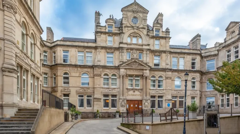
The Cardiff Coal Exchange opened in Mount Stuart Square in 1886. Cadw records the building as a major centre for international coal trading during the late nineteenth century. At the height of trading activity, around 200 men traded coal inside the exchange during the peak trading hour, while the building received an estimated 10,000 visitors each day.
How did the Coal Exchange change Mount Stuart Square?
The Coal Exchange transformed Mount Stuart Square from a residential and dockland space into an internationally significant commercial location.
Coal owners, shipping companies, brokers and agents conducted negotiations inside the exchange. Telephone technology also became part of the trading process.
The building therefore represents Cardiff’s position within international industrial commerce.
Mount Stuart Square also contains other heritage buildings. Heneb’s Historic Environment Record identifies Baltic House, a six-storey Edwardian Baroque-style building constructed in 1915, on the southern side of the square.
The combination of the Coal Exchange, Baltic House and surrounding historic buildings gives the square a strong connection with Cardiff’s industrial and maritime past.
How does Callaghan Square fit into Cardiff’s historic public realm?
Callaghan Square represents a later phase of Cardiff’s urban development, connecting the city centre with Cardiff Bay through a major public space and road system created during late twentieth-century regeneration and subsequently renamed in 2002.
Callaghan Square differs from Loudoun Square and Mount Stuart Square because its present form belongs largely to modern regeneration.
The square was previously known as Bute Square. It formed part of a major development programme linking central Cardiff with Cardiff Bay and the new Lloyd George Avenue.
The development was associated with the Cardiff Bay Development Corporation and its regeneration programme. The first stages were completed around 2000, establishing new connections between the city centre and Cardiff Bay.
The square was renamed Callaghan Square in 2002 in honour of former British Prime Minister James Callaghan, who represented Cardiff South and Penarth as a Member of Parliament.
What historic monument is associated with Callaghan Square?
A major historic feature is the statue of John Crichton-Stuart, 2nd Marquess of Bute.
The statue was created by Welsh sculptor J. Evan Thomas and unveiled in Cardiff in 1853. It originally stood in front of Cardiff Town Hall before being relocated several times. It eventually moved to Bute Square in the late twentieth century.
The monument connects the modern square with the nineteenth-century development of Cardiff Docks.
Cardiff Council’s current public-realm proposals also identify the statue as part of the square’s heritage. The council has proposed relocating it from Callaghan Square to a central position within the wider Kingsway public realm.
Callaghan Square therefore demonstrates how historic monuments can remain relevant even when the surrounding urban landscape changes substantially.
Why is Central Square historically important?
Central Square is important because it developed around Cardiff Central railway station and became one of the city’s principal transport and civic spaces. Its historic significance includes the listed 1930s railway station, twentieth-century redevelopment and its continuing role in Cardiff’s public realm.
Central Square sits directly outside Cardiff Central railway station.
The station itself has substantial architectural and historic importance. Cardiff Council’s listed-building record identifies the current station complex as dating principally from 1932–1934, when the Great Western Railway rebuilt the earlier 1895–1896 station.
The rebuilding created a new booking hall, passenger subway, platforms, platform buildings, bridges and railway infrastructure.
The station booking hall uses Portland stone and includes classical architectural details such as Doric pilasters and a prominent clock. The building is listed at Grade II.
Why does Central Square remain important today?
Central Square is both a historic location and an active transport interchange.
Cardiff Council’s transport programmes continue to treat the square as a key connection between Cardiff Central railway station, the city centre and Cardiff’s wider public transport network. Current plans also connect the area with Cardiff Crossrail and Cardiff Bay transport improvements.
The square demonstrates how historic public spaces evolve around changing transport technologies.
Its nineteenth-century railway origins, 1930s architecture and twenty-first-century transport infrastructure create several chronological layers within one location.
In 2026, Central Square also continues to function as a public space for cultural and heritage activity. Cadw used the square in July 2026 for its Women Through the Ages installation, featuring five life-sized sculptures representing women connected with Welsh history and heritage.
What historic public spaces are found around Cathays Park?
Cathays Park contains a group of planned civic gardens rather than one conventional square. Alexandra Gardens, Gorsedd Gardens and Friary Gardens form an important Edwardian and Victorian civic landscape surrounding Cardiff’s major governmental, cultural and educational buildings.
Cathays Park became one of Cardiff’s most important civic districts during the late nineteenth and early twentieth centuries.
The area developed from land associated with the Bute estate and became the setting for major public buildings and formal gardens.
The historic gardens include Alexandra Gardens, Gorsedd Gardens and Friary Gardens. Their layout was closely related to the surrounding civic architecture.
Historical research by Cardiff Naturalists’ Society records the development of these gardens around the civic buildings and notes the importance of acquiring public open spaces as Cardiff’s population expanded. Cardiff had more than 160,000 residents by 1900, creating increasing demand for recreational and ornamental public spaces.
Why do the Cathays Park gardens matter?
The gardens demonstrate the civic ambitions of a rapidly growing capital city.
Unlike dockland squares such as Loudoun Square and Mount Stuart Square, Cathays Park was designed around government, education, culture and civic identity.
The surrounding buildings include major institutions associated with Cardiff’s development as the capital of Wales.
The gardens also form part of the city’s protected historic environment. Cardiff Council’s conservation information includes Cathays Park within its designated conservation framework.
Their importance comes from the relationship between landscape and architecture. The open spaces provide visual settings for civic buildings while maintaining historic pedestrian routes and public access.
How did Cardiff’s industrial growth create historic squares?
Cardiff’s industrial expansion transformed the city during the nineteenth century, creating new residential districts, commercial centres and dock communities. Squares such as Loudoun Square and Mount Stuart Square directly reflect this growth and the economic importance of Cardiff Docks and coal exports.
Cardiff’s industrialisation reshaped its population and physical geography.
The opening of the Bute West Dock in 1839 accelerated development around Butetown. New streets and residential areas followed, while Cardiff’s maritime economy attracted people from different occupations and backgrounds.
The planned squares formed part of this expansion.
Loudoun Square became associated with residential development. Mount Stuart Square became closely connected with commerce and the coal trade.
Historical research into Butetown identifies the area as a complex urban environment containing industrial sites, residential streets, religious buildings, railway infrastructure and commercial premises.
How did the docks influence Cardiff’s public spaces?
The docks generated demand for housing, commercial premises, transport routes and public facilities.
Cardiff’s connection to international maritime trade also produced a diverse population. Butetown became one of Britain’s most distinctive dock communities, with people from different national and cultural backgrounds living and working in the area.
Public squares therefore served several functions. They provided residential settings, commercial addresses, circulation routes and community spaces.
The surviving historic landscape records these economic relationships.
Mount Stuart Square’s Coal Exchange represents international commercial activity, while Loudoun Square represents planned residential development associated with the expanding dock economy.
Together, they show how Cardiff’s public spaces were closely connected to industrialisation.
How are Cardiff’s historic public squares protected?
Cardiff’s historic squares and surrounding buildings are protected through conservation areas, listed-building controls, scheduled-monument legislation and planning policies. These systems preserve architectural character, archaeological evidence, historic landscapes and important public spaces while allowing carefully managed urban change.
Cardiff Council states that important buildings, archaeological remains and open spaces receive protection through the planning system.
The city currently has 27 conservation areas. It also contains around 1,000 listed buildings, around 300 locally listed buildings and 31 scheduled monuments.
A conservation area protects the character of an area rather than simply protecting individual buildings.
Mount Stuart Square, Cathays Park and several other historic Cardiff districts therefore benefit from area-wide conservation policies.
What does listed status mean for Cardiff’s historic buildings?
Listed-building status recognises buildings with special architectural or historic interest.
Cardiff Council explains that listed-building consent is required for alterations or extensions that affect the character of a listed building or its curtilage. Unauthorised works to a listed building constitute a criminal offence.
This system matters because historic squares depend on the relationship between buildings and open space.
A nineteenth-century square loses part of its historic character if its surrounding buildings, façades, scale or important architectural details are substantially altered without appropriate controls.
Protection therefore operates at several levels, from individual buildings to complete conservation areas.
How can visitors explore Cardiff’s historic public squares?
Visitors can explore Cardiff’s historic public squares through a connected city-centre and docklands walking route. Central Square, the medieval core, Callaghan Square, Mount Stuart Square, Loudoun Square and Cathays Park each reveal different phases of Cardiff’s urban development.
A historic squares itinerary works best as a chronological journey.
Start at Central Square beside Cardiff Central railway station. The Grade II-listed station provides a clear introduction to Cardiff’s twentieth-century transport history.
Continue north towards the medieval core around High Street, St John Street, Working Street and Womanby Street. This area shows the historic street structure that developed around Cardiff Castle.
Move south towards Callaghan Square to examine the relationship between modern regeneration and nineteenth-century Cardiff. The statue of the 2nd Marquess of Bute provides a direct link with the city’s dock-building era.
Continue towards Butetown for Mount Stuart Square and Loudoun Square.
Mount Stuart Square provides the strongest connection with Cardiff’s international coal trade through the former Coal Exchange.
Loudoun Square provides a different perspective through its residential and community history.
Finish in Cathays Park, where Alexandra Gardens, Gorsedd Gardens and Friary Gardens illustrate the civic landscape associated with Cardiff’s development as the capital of Wales.
This route covers medieval Cardiff, Victorian industrial expansion, dockland communities, railway development, civic planning and contemporary regeneration within one urban area.
Explore More Area Guide
Oldest Libraries in Cardiff: History of Cardiff’s Historic Libraries
Biggest Parks in Cardiff Ranked: Bute Park, Roath Park & More
Why do Cardiff’s historic public squares still matter?
Cardiff’s historic public squares remain important because they preserve evidence of the city’s medieval origins, industrial expansion, maritime communities, civic ambitions and modern regeneration. Their buildings, monuments, gardens and street patterns provide physical records of Cardiff’s changing urban identity.
Historic public spaces are valuable because they connect different periods of urban development.
Loudoun Square records the expansion of Butetown and the social history of Cardiff Docks. Mount Stuart Square records the international coal trade. Central Square records railway development and twentieth-century transport architecture. Callaghan Square records late twentieth-century regeneration. Cathays Park records Cardiff’s civic development.
The spaces also demonstrate the scale of change that Cardiff has experienced.
Cardiff’s historic environment is not preserved as a static museum. Current projects continue to alter transport routes, public spaces and pedestrian connections. Cardiff Council’s Castle Street improvements, for example, include changes to paving, cycling infrastructure, crossings, drainage, lighting and street furniture, with special heritage controls applying to works near Cardiff Castle.
The continuing challenge is to retain historic character while maintaining functional public spaces for a growing city.
Cardiff’s historic squares therefore have relevance beyond architectural heritage. They provide evidence for understanding medieval settlement, industrialisation, migration, commerce, transport, housing, civic government and urban regeneration.
Their significance is strongest when the surrounding buildings, monuments, gardens and street patterns are considered together.
The historic public-space legacy of Cardiff
Cardiff’s public squares form a layered record of urban history.
The medieval town created the street framework. Nineteenth-century dock development created planned residential and commercial squares. Industrial wealth produced major commercial buildings. Railway expansion created new transport spaces. Civic planning created formal gardens. Modern regeneration reshaped central Cardiff again.
The result is a city where different periods remain visible within a relatively compact area.
For visitors, these spaces provide a practical way to understand Cardiff’s history on foot. For residents, they remain functioning parts of the city’s public realm. For heritage planners, they provide historic evidence that requires continued conservation and careful management.
Cardiff’s historic public squares are therefore not isolated monuments. They are active urban spaces where the city’s medieval, industrial, maritime, civic and modern histories remain connected.
What are the main historic public squares in Cardiff?
Important historic public spaces include Loudoun Square, Mount Stuart Square, Callaghan Square and Central Square, along with the formal civic gardens of Cathays Park. Each reflects a different stage of Cardiff’s development.