![Exploring Hidden Streets in Roath, Cardiff [2026]](https://cardiffdaily.co.uk/wp-content/uploads/2026/08/Exploring-Hidden-Streets-in-Roath-Cardiff-2026-860x482.webp)
The hidden streets in Roath are characterized by 19th-century Victorian grid layouts, dense networks of residential terraces, and service lanes constructed during Cardiff’s rapid industrial expansion between 1880 and 1910.
- How did industrialization and estate ownership shape the development of Roath’s secondary roadways?
- What are the primary architectural features and material characteristics found within Roath’s historic residential lanes?
- What role did municipal sanitation and transportation upgrades play in the evolution of Roath’s urban infrastructure?
- How do contemporary preservation efforts and modern urban pressures impact the historic fabric of Roath’s side streets?
The spatial organization of Roath reflects the massive urbanization wave that transformed South Wales during the height of the coal export boom. Historically, Roath originated as a medieval agricultural settlement centered around the Manor of Roath. However, the modern street grid emerged through speculative housing developments commissioned by major landowners, notably the Bute Estate and the Mackintosh Estate.
Architecturally, these secondary and tertiary corridors—such as Keppoch Street, Plasnewydd Road, and various unnamed mews lanes—were engineered to maximize housing capacity for industrial workers, artisans, and clerks. Unlike the wide commercial arteries of Albany Road and Wellfield Road, the hidden residential lanes prioritized high-density, two-story brick and stone terraced houses. Builders utilized local clay to manufacture distinctive red and yellow bricks, establishing a uniform chromatic profile across the district.
The infrastructure of these hidden streets incorporated narrow carriageways flanked by slate-paved pedestrian pathways and rear service alleys. These rear lanes served a critical functional role in nineteenth-century municipal management, allowing coal deliveries, waste collection, and sanitary access without disrupting front-facing domestic traffic. Urban planners of the Cardiff Corporation enforced strict building regulations under the Public Health Acts, ensuring that drainage systems, damp-proof courses, and adequate ventilation were integrated into every structural block. Consequently, the architectural framework represents a textbook example of Victorian speculative town-planning adapted to a booming port city economy.
How did industrialization and estate ownership shape the development of Roath’s secondary roadways?
Industrialization and estate ownership shaped Roath’s secondary roadways by converting agricultural land into high-density residential grids managed by aristocratic landowners like the Marquis of Bute.
During the late eighteenth and nineteenth centuries, Cardiff evolved from a small market town into the largest coal-exporting port in the world. This economic acceleration drove a massive demographic influx into the capital of Wales. To house the incoming workforce, agricultural fields managed by feudal successor estates were systematically surveyed, parceled, and sold or leased to private property developers. The Marquis of Bute, Lord Tredegar, and the Mackintosh family held primary dominion over these territories, dictating the timing and layout of suburban growth.
The physical construction of secondary streets followed rigid geometric patterns designed to optimize land monetization. Surveyors laid out parallel residential corridors intersected by perpendicular transverse streets, creating distinct housing blocks. This top-down urban management model meant that street names often reflected estate connections, family members, or historical associations with Welsh landowning gentry. For instance, streets branching off Newport Road and City Road were meticulously sequenced to accommodate terraced housing typologies that ranged from modest two-up two-down workers’ dwellings to larger bay-windowed properties destined for middle-class merchants.
Furthermore, municipal authorities exerted increasing control over civil engineering standards as the nineteenth century progressed. The Cardiff Corporation Act and subsequent local bylaws mandated paved surfaces, integrated stormwater drainage, and gas lighting infrastructure across all newly opened residential lanes. This transition from unpaved rural tracks to macadamized urban streets ensured that Roath’s hidden network could sustain heavy domestic usage, horse-drawn transport, and later, motorized vehicular traffic without structural collapse.
What are the primary architectural features and material characteristics found within Roath’s historic residential lanes?
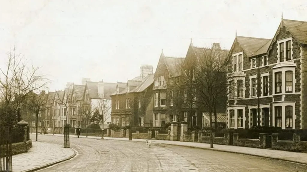
Roath’s historic residential lanes feature distinct Victorian architectural components including decorative terracotta stonework, slate mansard roofs, cast-iron railings, and narrow front forecourts.
The visual identity of these hidden corridors is defined by a strict adherence to Victorian vernacular design principles executed on a mass scale. Builders constructed facades primarily using local Pennant sandstone foundations paired with red brick elevations. Decorative elements were standardized yet ornate, featuring polychromatic brick banding, segmental window arches, and rendered stucco lintels above timber sash windows.
Front elevations frequently incorporate cantilevered bay windows designed to maximize interior daylight penetration within narrow street canyons. Entryways typically feature recessed porches accented by encaustic floor tiles in geometric patterns, accompanied by original timber panel doors and fanlights. Boundary treatments along the pavement edge consist of low brick dwarf walls surmounted by decorative wrought-iron railings, defining the threshold between public pedestrian zones and private domestic space.
Roof structures across these terraced formations rely on Welsh slate cladding laid over timber framing, terminating in shared party walls designed to prevent fire spread between adjacent households. Chimney stacks pierce these roofscapes at regular intervals, reflecting the original reliance on decentralized coal fireplaces for domestic heating and cooking. Rear elevations reveal a functional vernacular, characterized by continuous outshot extensions—commonly known as back kitchens or sculleries—which expanded the usable interior footprint of the narrow footprint dwellings.
Explore More Area Guide
Secret Gardens in Cardiff: Hidden Parks Guide 2026
Average Income Trends Reveal Cardiff Earnings 2026
What role did municipal sanitation and transportation upgrades play in the evolution of Roath’s urban infrastructure?
Municipal sanitation and transportation upgrades transformed Roath’s infrastructure through the installation of underground earthenware sewerage networks, paved roadbeds, and tramway integration.
As Cardiff’s population surged past 150,000 residents by the turn of the twentieth century, public health crises prompted radical interventions by municipal engineers. The Cardiff Corporation implemented comprehensive sanitation reforms, replacing primitive cesspits and open drainage ditches with subterranean vitrified clay pipe networks. Every residential lane in Roath was systematically connected to this centralized municipal sewerage system, dramatically reducing waterborne disease outbreaks such as cholera and typhoid.
Simultaneously, surface infrastructure underwent continuous modernization. Roadbeds transitioned from basic gravel and compacted earth to durable granite sett paving and macadamized surfaces capable of shedding heavy seasonal rainfall.
Curbs and gutters were cast from durable Pennant stone, directing surface water toward newly constructed stormwater catch basins linked to the Roath Brook culverts.
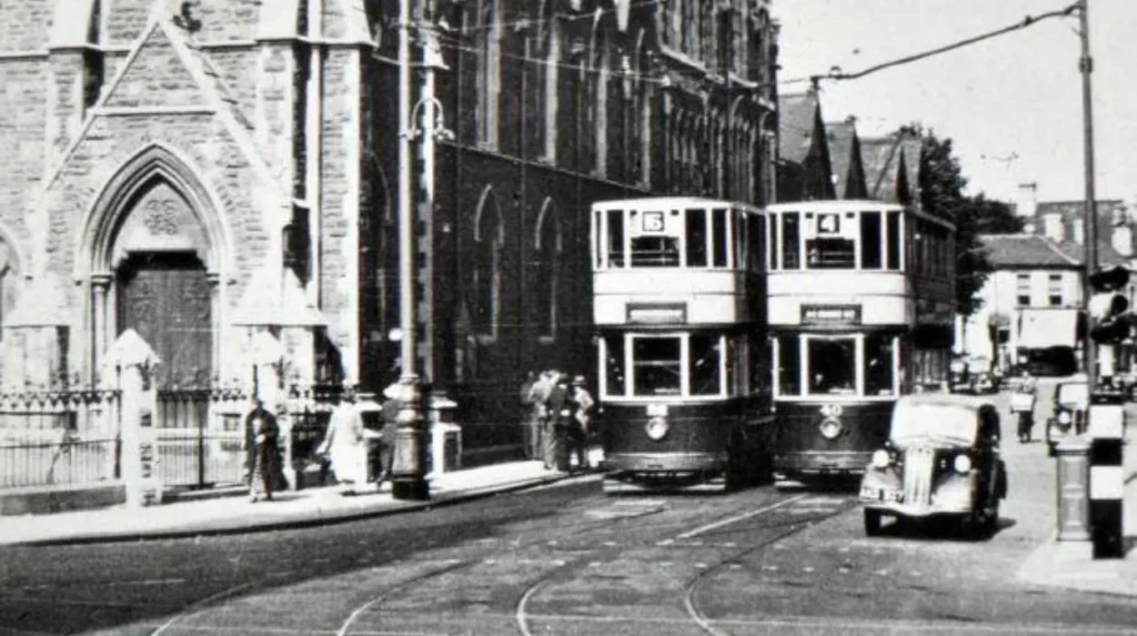
Transportation networks further influenced the spatial hierarchy of the district. While major arteries like Albany Road and City Road hosted electrified tram lines operated by Cardiff Corporation Tramways, the adjacent hidden streets served as pedestrian feeders. Residents walked short distances from their front doors to catch public transit, reinforcing a pedestrian-centric urban model.
Gas street lighting, managed by municipal utility departments, illuminated these secondary corridors, enhancing night-time security and integrating the interior residential grid into the twenty-four-hour rhythm of the expanding industrial city.
How do contemporary preservation efforts and modern urban pressures impact the historic fabric of Roath’s side streets?
Contemporary preservation efforts and modern urban pressures impact Roath’s historic fabric through heritage conservation area designations, housing subdivision trends, and increased vehicular congestion.
In the modern era, the historical integrity of Roath faces constant tension between architectural conservation and urban adaptation. Designated conservation areas, such as the Plasnewydd Conservation Area, impose strict planning controls on property owners. These regulations govern exterior alterations, requiring replacement windows to match original timber sash configurations and restricting inappropriate cladding materials that degrade the Victorian streetscape.
However, socio-economic shifts—particularly Roath’s proximity to university campuses and the city center—have driven widespread property subdivision. Large single-family Victorian villas and expansive terraced houses have frequently been partitioned into multi-occupancy student apartments or flats.
This demographic shift introduces modern infrastructural challenges, including heightened parking demand within narrow lanes originally designed exclusively for pedestrian and light horse-drawn transit.
Furthermore, municipal authorities grapple with balancing heritage protection against climate resilience mandates. Retrofitting historic properties with modern insulation, double glazing, and solar energy installations requires careful architectural navigation to avoid compromising exterior aesthetic values and historic masonry breathability.
Despite these pressures, active local history societies and civic trusts continue to document, protect, and advocate for the preservation of Roath’s unique nineteenth-century urban landscape, ensuring that its foundational structural narrative remains intact for future generations.
What are the hidden streets in Roath, Cardiff?
Hidden streets in Roath are historic residential lanes shaped by Victorian urban expansion during Cardiff’s industrial growth. These streets include smaller corridors such as Keppoch Street, Plasnewydd Road, and surrounding terraced housing lanes that developed between the late nineteenth and early twentieth centuries.