The conflict arises from the tension between the Cardiff Local Development Plan housing targets and the preservation of the historic semi-rural character of Old St Mellons. Urban expansion onto greenfield sites threatens local biodiversity and existing community infrastructure capacity.
- How does the Cardiff Local Development Plan affect Old St Mellons?
- What are the environmental impacts of development in Old St Mellons?
- Which planning laws govern the battles in Old St Mellons?
- How does housing development affect local infrastructure and traffic?
- What is the role of community action groups in planning battles?
- What are the future projections for development in Old St Mellons?
- How do developers balance profit with environmental preservation?
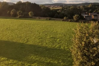
Old St Mellons is a village located on the northeastern edge of Cardiff, Wales. It serves as a primary site for the city’s strategic housing expansion. The Cardiff Local Development Plan 2006 to 2026 identifies specific strategic sites for thousands of new residential units. These sites often consist of greenfield land which provides essential ecosystem services and recreational value to the current residents.
The Welsh Government requires local authorities to maintain a five-year land supply for housing. Cardiff faces significant population growth projections, necessitating the construction of approximately 41,000 new homes by 2026. Old St Mellons sits within Strategic Site F, known as the North East Cardiff extension. This area is designated for 4,500 homes during the current plan period and potentially more in subsequent decades.
Residents argue that the conversion of fields into housing estates destroys the village identity. They highlight the loss of the “Green Wedge,” a planning designation intended to prevent urban sprawl. The planning battles focus on whether the economic benefit of new housing outweighs the environmental cost of losing permeable land. Soil sealing occurs when rural land is paved over, increasing surface water runoff and local flood risks.
The infrastructure in Old St Mellons was originally designed for a low-density population. Narrow roads such as Newport Road and Tyr Winch Road currently experience high traffic volumes. Opponents of new developments state that the cumulative impact of multiple housing projects exceeds the capacity of the local highway network. Developers are required to provide Section 106 contributions to mitigate these effects through new schools or road improvements.
How does the Cardiff Local Development Plan affect Old St Mellons?
The Cardiff Local Development Plan dictates the legal framework for land use and specifies that Old St Mellons must accommodate a significant portion of the city’s housing growth. It reallocates former greenfield land for residential and mixed-use purposes.
The Local Development Plan, or LDP, is the statutory document that guides all planning decisions in the Cardiff Council area. It identifies where new homes, jobs, and infrastructure will be located. For Old St Mellons, the LDP signifies a shift from a rural boundary to an integrated urban suburb. The plan prioritizes high-growth strategies to meet the demands of a growing capital city.
Strategic Site F encompasses land north of the M4 motorway and south of the surrounding villages. This site includes a large portion of the acreage surrounding Old St Mellons. The LDP mandates a master-planning approach to ensure that new homes are accompanied by essential services. This includes three new primary schools, one secondary school, and several district shopping centers to support the influx of residents.
The LDP also contains policies regarding the protection of the environment. Policy EN1 and Policy EN3 focus on the protection of the countryside and biodiversity. However, these policies are often balanced against the need for housing delivery. In Old St Mellons, the “Green Wedge” was reduced in size during the LDP adoption process to allow for the North East Cardiff expansion.
Legal challenges to the LDP often focus on the accuracy of population projections. If the actual population growth is lower than the projected 41,000 homes, the necessity of building on greenfield sites in Old St Mellons is questioned. Planning inspectors from the Welsh Government oversee the LDP to ensure it meets national housing standards and sustainability goals.
What are the environmental impacts of development in Old St Mellons?
Development in Old St Mellons leads to habitat fragmentation, the loss of ancient hedgerows, and increased pressure on local SSSIs. It alters the local hydrology by replacing natural drainage with artificial systems, potentially increasing downstream flood risks.
Old St Mellons is home to diverse flora and fauna that rely on the interconnected network of fields and woods. The removal of hedgerows for site access roads disrupts wildlife corridors used by protected species. These species include the hazel dormouse, various bat species, and the great crested newt. European Protected Species legislation requires developers to conduct thorough ecological surveys before starting construction.
The Gwent Levels, a Site of Special Scientific Interest or SSSI, is located in close proximity to the southern boundary of Old St Mellons. This area is a unique landscape of reclaimed coastal grazing marshes. Runoff from new housing developments can introduce pollutants into the “reens” or drainage ditches. Increased siltation and chemical runoff from roads threaten the rare aquatic plants and invertebrates found in the Levels.
Carbon sequestration is another factor in the environmental debate. Trees and grasslands in the village act as carbon sinks, absorbing atmospheric carbon dioxide. The conversion of these spaces into residential areas reduces the net carbon absorption of the region. While new homes are built to modern energy efficiency standards, the initial loss of natural biomass represents a significant environmental deficit.
Air quality is a growing concern for the residents of Old St Mellons. The increase in private vehicle use associated with new housing estates leads to higher levels of nitrogen dioxide. The proximity of the A48 and M4 motorways already contributes to elevated particulate matter. Removing green buffers between the village and these major roads reduces the natural filtration of pollutants by vegetation.
Which planning laws govern the battles in Old St Mellons?
Planning battles are governed by the Planning or Wales Act 2015 and the Well-being of Future Generations Act 2015. These laws mandate that all development must be sustainable and provide social, economic, environmental, and cultural benefits.
The Planning or Wales Act 2015 provides the legal basis for the development of the LDP. it ensures that the planning system is efficient and supports the delivery of homes. Under this act, the Welsh Government has the power to intervene in planning applications that are of national significance. This often occurs when a local council rejects a development that aligns with national housing targets.
The Well-being of Future Generations Act 2015 is a unique piece of Welsh legislation. It requires public bodies to consider the long-term impact of their decisions. In Old St Mellons, activists use this act to argue that destroying green spaces harms the well-being of future residents. They argue that the right to access nature is essential for mental and physical health.
Planning Policy Wales, or PPW, provides the national policy framework. The current edition emphasizes a “placemaking” approach. This means that new developments should not just be clusters of houses but should create high-quality places where people want to live. PPW prioritizes the use of brownfield land over greenfield land, though in Cardiff, the lack of brownfield sites makes greenfield development common.
Section 106 of the Town and Country Planning Act 1990 allows local authorities to enter into legal agreements with developers. These agreements are used to secure infrastructure improvements. In Old St Mellons, Section 106 funds have been earmarked for the construction of a new primary school and improvements to the St Mellons Community Centre. These agreements are often the subject of intense negotiation.
How does housing development affect local infrastructure and traffic?
Housing development increases the volume of traffic on local arterial roads and puts pressure on existing school places and healthcare facilities. Without significant upgrades to the road network and public transport, congestion levels in Old St Mellons will rise.
Old St Mellons is situated along the Newport Road corridor, which is a major route into Cardiff city center. The addition of thousands of homes increases the number of daily vehicle trips. Planning applications for sites like the Churchlands development include detailed Transport Assessments. These assessments often conclude that with specific road widening and signal changes, the network can accommodate the growth.
Residents frequently contest these findings, citing existing delays at the Wern Fawr Lane and Tyr Winch Road junctions. The “rat-running” phenomenon occurs when drivers use narrow residential streets to avoid congestion on main roads. This creates safety concerns for pedestrians and cyclists in the older parts of the village. The proposed Eastern Bay Link road is intended to alleviate some of this pressure.
Public transport provision is a critical component of sustainable development. The Cardiff Capital Region Metro project aims to improve rail and bus links. In Old St Mellons, a new railway station at St Mellons Parkway is planned to provide a direct link to Cardiff Central and London Paddington. This station is seen as a way to reduce reliance on private cars for future residents.
Education and healthcare facilities must expand to meet the needs of a larger population. The St Mellons Medical Centre and local dental practices currently operate at high capacity. New developments are expected to provide land or funding for new health centers. However, there is often a lag between the completion of homes and the opening of new public services, leading to a temporary decline in service quality.
What is the role of community action groups in planning battles?
Community action groups organize public opposition, hire independent planning consultants, and represent local interests during council hearings. They serve as a watchdog to ensure that developers adhere to environmental and planning regulations.
The Old St Mellons Community Council is the first tier of local government and plays an active role in reviewing planning applications. While they do not have the power to reject applications, their recommendations are considered by the Cardiff Council Planning Committee. They often voice the collective concerns of the residents regarding the scale and density of new housing projects.
Save Our Green Spaces is an example of an informal group formed by residents to protest against specific developments. These groups use social media and public meetings to raise awareness. They gather evidence on local flooding issues or sightings of protected species to present during the planning consultation process. Their involvement ensures that local knowledge is integrated into the decision-making process.
Professional representation is often necessary to challenge large-scale developers. Community groups sometimes crowdfund to hire planning lawyers or ecologists. These experts can identify technical flaws in a developer’s application, such as inadequate drainage plans or underestimated traffic impacts. This professionalization of community resistance has become a common feature of planning battles in South Wales.
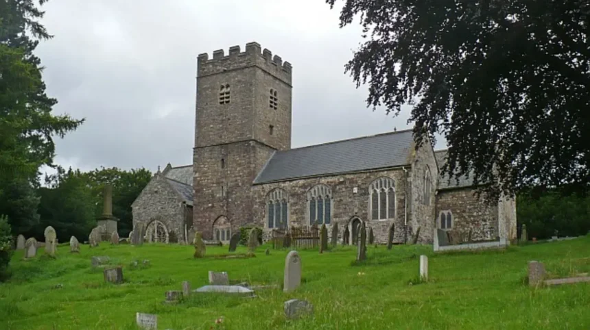
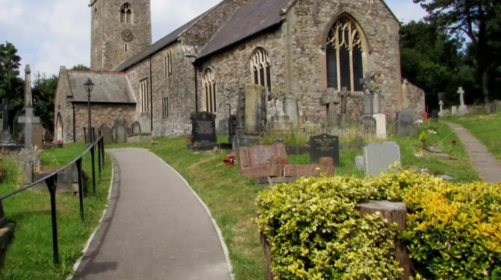
Community action also focuses on the preservation of heritage assets. Old St Mellons contains several listed buildings and a conservation area. Residents work to ensure that new developments do not negatively impact the setting of these historic structures. This includes maintaining sightlines to the St Mellons Church and preserving the character of the stone-walled lanes that define the village.
What are the future projections for development in Old St Mellons?
Future projections indicate continued residential growth through the 2030s as Cardiff expands its urban footprint to the northeast. The completion of the St Mellons Parkway and the South Wales Metro will catalyze further high-density development.
The Replacement Local Development Plan, covering the period up to 2036, is currently under preparation. This plan will determine if additional greenfield sites in Old St Mellons are required to meet updated housing targets. Initial assessments suggest that the demand for housing in the Cardiff region remains high. This is driven by internal migration and a trend toward smaller household sizes.
St Mellons Parkway is expected to be a major driver of economic and residential growth. This “transit-oriented development” model encourages higher density housing within walking distance of the station. This could lead to a shift from traditional detached housing to apartments and townhouses. The project includes a business park that aims to create thousands of jobs in the professional services and technology sectors.
Climate change adaptation will play a larger role in future planning battles. As the risk of extreme weather events increases, the value of green spaces for flood attenuation becomes more significant. Future developments will likely be required to implement more robust Sustainable Drainage Systems, or SuDS. This includes the use of permeable paving, swales, and attenuation ponds to manage rainwater.
The tension between green spaces and new homes is unlikely to disappear. As the urban boundary of Cardiff moves closer to the neighboring authority of Newport, the concept of a “Green Belt” may be formally reintroduced. This would provide a permanent legal protection for the remaining fields around Old St Mellons. The outcome of the current planning battles will define the landscape of the region for the next century.
How do developers balance profit with environmental preservation?
Developers balance profit and preservation by implementing mandatory biodiversity net gain strategies and utilizing Section 106 agreements. They focus on high-density designs that maximize units while leaving designated areas for public open space.
For a developer, the primary objective is the financial viability of a project. The cost of land in Old St Mellons is high due to its desirable location and proximity to transport links. To ensure profit, developers must reach a specific “unit count” per acre. This often leads to designs that prioritize smaller gardens and narrower streets to fit more homes into the allocated space.
The “Biodiversity Net Gain” principle is becoming a standard requirement in UK planning. It requires that a development leaves the natural environment in a better state than it was before construction. Developers achieve this by creating new habitats on-site, such as ponds or wildflower meadows. In Old St Mellons, developers often incorporate “green corridors” into their site layouts to allow for wildlife movement.
Sustainable Drainage Systems are an essential part of modern development costs. These systems prevent the local sewer network from being overwhelmed during heavy rain. While SuDS require land that could otherwise be used for housing, they are necessary for planning approval. Developers view these features as “amenity space” that can increase the market value of the homes by providing green views.
Corporate Social Responsibility, or CSR, also influences developer behavior. Large firms such as Redrow, Persimmon, and Taylor Wimpey are under public scrutiny regarding their environmental impact. Engaging with community groups and making voluntary improvements to local parks can improve their public image. This facilitates a smoother planning process for future projects in the region.
Who 2016 urban green spaces and health?
The 2016 World Health Organization report emphasizes that urban green spaces are essential for mental health and physical activity. In Old St Mellons, preserving these areas is vital to mitigate urban heat and support the well-being of local residents.
Why are garden centres closing down?
Garden centres often close due to rising land values and operational costs, leading to redevelopment for housing. In Old St Mellons, the conversion of such sites into residential units highlights the ongoing tension between commercial viability and community green space.
What is blue diamond UK?
Blue Diamond UK is a leading garden centre group operating across the United Kingdom and Channel Islands. The company focuses on high-quality plants and retail experiences, representing the type of green infrastructure at risk during intensive urban planning shifts.
Can I convert my gift card to cash?
Generally, retail gift cards cannot be converted into cash and are non-refundable. This standard policy applies across most UK garden centres and retailers, requiring customers to utilize the balance for horticultural products or services within the specific store network.
How does a cafe menu differ from a restaurant menu?
A cafe menu typically focuses on light meals, snacks, and specialized beverages with faster service. In contrast, a restaurant menu offers multi-course dining and formal service, reflecting the different infrastructure needs during the planning of new community hubs.