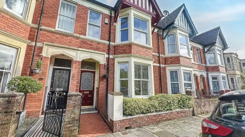
Roath is one of Cardiff’s clearest examples of Victorian urban expansion. Its transformation from a largely rural parish into a densely built residential district took place mainly between the 1850s and the early 1900s. The process was driven by Cardiff’s industrial growth, rising population, expanding docks, new transport connections, private estate development, municipal investment and demand for housing.
- Why was Roath rural before the Victorian period?
- What caused Roath to urbanise during the Victorian era?
- How quickly did Roath’s population grow?
- How did landowners shape Victorian Roath?
- Why were terraced houses so important in Roath?
- Which streets show Roath’s Victorian development?
- How did Cardiff’s 1875 boundary expansion affect Roath?
- How did Victorian public health influence Roath?
- How did Roath Park reinforce the Victorian identity of the area?
- Why did Victorian Roath contain both terraces and villas?
- How did churches, schools and businesses complete Victorian Roath?
- How did Cardiff’s wider industrial economy shape Roath?
- Why did transport matter to Victorian Roath?
- What architectural features reveal Roath’s Victorian past?
- Why is Roath described as Victorian Cardiff?
- How does Victorian Roath influence Cardiff today?
- What is the historical significance of Roath’s Victorian transformation?
The physical character created during this period remains visible today. Terraced houses, villas, churches, schools, commercial streets, planned roads and Roath Park form a historic landscape shaped by nineteenth-century development. Cardiff Council and Cadw continue to recognise important parts of this built environment through conservation and heritage designations.
Understanding why Roath became Victorian Cardiff requires more than looking at its houses. The district developed through a connected process involving land ownership, industrial employment, population movement, housing finance, local government, public health, transport and recreational planning.
Why was Roath rural before the Victorian period?
Roath was predominantly rural before rapid Victorian expansion, with farms, estates, cottages, a historic mill and large areas of agricultural land surrounding the developing town of Cardiff. Its population remained only a few hundred before the 1850s.
Roath had a long history before becoming a Cardiff suburb. Archaeological and historical evidence records activity around Roath Mill for centuries. The Cardiff Archaeological Society identifies references to the mill from the medieval period, including a reference connected with Tewkesbury Abbey in 1102 and later records associated with Keynsham Abbey.
The nineteenth-century landscape still contained substantial estates. Roath Court and Plasnewydd were important landholdings. The Tredegar Estate also controlled significant parts of the parish.
Population figures demonstrate how rural Roath remained during the early nineteenth century. The Roath Local History Society records a population of 236 in 1801, 269 in 1821, 272 in 1831, 298 in 1841 and approximately 300 in 1851. In 1841, the parish contained only 60 houses.
This landscape changed rapidly after 1850. The existing farms and estates became sources of development land as Cardiff expanded eastwards.
What caused Roath to urbanise during the Victorian era?
Roath urbanised because Cardiff became a major industrial port, creating employment, population growth and housing demand. The city’s expanding coal trade attracted workers, artisans, merchants and professionals who required new homes outside the older urban core.
Cardiff’s nineteenth-century economic expansion was closely connected to the South Wales coalfield. Cardiff docks handled increasing quantities of coal and other industrial goods. The resulting employment supported shipping, engineering, transport, construction, commerce and associated services.
Housing demand followed employment growth.
Roath was particularly suitable for expansion because it lay immediately east of the established town. Developers could build on comparatively open land while remaining close to Cardiff’s workplaces and commercial centre.
The Roath Local History Society describes the 1850s as the beginning of the parish’s transformation from a rural area into a densely populated suburb. Its research records 3,044 residents in 1861 compared with roughly 300 in 1851.
The scale of change was extraordinary.
The recorded population reached 7,986 in 1871, 23,096 in 1881, 39,657 in 1891 and 61,074 in 1901.
These figures show that Roath did not simply experience gradual suburban growth. Its population increased by more than 200 times between the early nineteenth century and 1901.
How quickly did Roath’s population grow?
Roath’s population increased from about 292 people in 1851 to 61,074 in 1901. The largest increases occurred during the Victorian decades, when new streets, terraces, shops, churches and public facilities expanded alongside Cardiff’s industrial economy.
The census figures provide one of the strongest measures of Roath’s Victorian transformation.
| Census year | Recorded population |
|---|---|
| 1801 | 236 |
| 1811 | 211 |
| 1821 | 269 |
| 1831 | 272 |
| 1841 | 298 |
| 1851 | 292 |
| 1861 | 3,044 |
| 1871 | 7,986 |
| 1881 | 23,096 |
| 1891 | 39,657 |
| 1901 | 61,074 |
The Roath Local History Society notes that the 1851 figure excludes 102 military personnel and their families at Longcross Barracks in its adjusted analysis.
The growth after 1851 was therefore the defining feature of Victorian Roath.
The 1861 figure already represented a dramatic increase. By 1881, the population had reached more than 23,000. By 1901, Roath contained more than 61,000 people.
The figures also explain why housing construction became central to the district’s development.
How did landowners shape Victorian Roath?
Large landowners controlled how development occurred by leasing building plots, approving layouts and influencing architectural standards. The Tredegar, Roath Court, Plasnewydd and other estates therefore shaped the streets, housing types and appearance of Victorian Roath.
Roath was not developed through a single municipal housing scheme. Much of its expansion occurred through private estates.
The Roath Local History Society identifies Tredegar as an important early developer. Early street development appeared on Tredegar land around the Cardiff boundary, including areas around City Road and Upper Splott Farm.
The Roath Court Estate also became a major source of residential land. Its urbanisation began around 1850 and continued for more than a century.
Plasnewydd developed later. The Richards family estate, which became associated with the Mackintosh Estate, did not begin major urban development around Albany Road until 1884.
This explains why different parts of Roath contain distinct architectural characteristics.
Landowners controlled building plots and often established estate conditions. The Roath Local History Society records the widespread use of 99-year leases. Ground landlords retained long-term interests in the land while builders and occupiers developed the properties.
Estate control also influenced architectural consistency.
Architects prepared plans for streets and houses. Local authorities then examined proposals under the applicable building and public-health arrangements. Individual builders introduced small decorative differences while working within broader estate requirements.
Why were terraced houses so important in Roath?
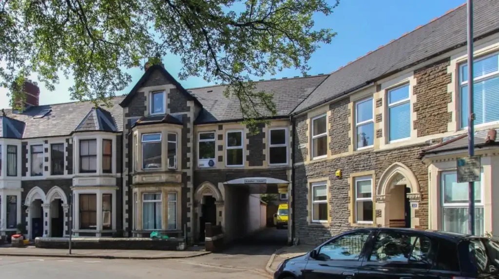
Terraced housing allowed Victorian developers to accommodate large numbers of families on limited urban land. Connected houses reduced construction costs, maximised plots and provided practical homes close to Cardiff’s industrial employment and commercial streets.
Terraced housing became one of the defining forms of Victorian Roath.
A terrace consists of multiple houses joined by shared walls. Each property normally has its own entrance and internal accommodation. This arrangement produced a high residential density without requiring apartment blocks.
Roath needed this form because population growth was extremely rapid.
The district attracted artisans, industrial workers, tradespeople and families moving from older parts of Cardiff. The Roath Local History Society specifically identifies the movement of artisans from poorer and older parts of Cardiff as an important factor in residential expansion.
Terraces also worked efficiently with the estate system.
Developers could divide a large field into streets and individual plots. Builders could then construct repeated house types along those streets.
This produced recognisable Victorian streetscapes with repeated building lines, similar roof heights, consistent frontages and regular windows.
The pattern remains visible across areas of Roath and neighbouring Plasnewydd.
Which streets show Roath’s Victorian development?
Several surviving streets demonstrate the sequence of Roath’s Victorian expansion, including Wordsworth Avenue, Partridge Road, Oakfield Street, City Road and streets around Albany Road. Their construction reflects different stages of nineteenth-century estate development.
Wordsworth Avenue provides an early example.
The Roath Local History Society records that the road was laid out around 1850 on the Roath Court Estate. It developed as a tree-lined residential street with larger family houses rather than dense working-class terraces.
Partridge Road and Oakfield Street were also being developed by 1859.
City Road developed along an important route between Cardiff and the expanding eastern suburbs. Its later commercial character reflected increasing population and demand for shops and services.
Albany Road became particularly important as the Plasnewydd and Mackintosh Estate developed from the 1880s.
These streets demonstrate that Victorian Roath was not uniform. Different estates developed different types of housing and different street layouts.
The result was a layered suburban landscape containing modest terraces, larger houses, villas, commercial premises and institutional buildings.
How did Cardiff’s 1875 boundary expansion affect Roath?
Cardiff incorporated Roath into the borough in 1875, bringing the expanding suburb under Cardiff’s municipal administration. This strengthened coordinated responsibility for roads, sanitation, public works and urban infrastructure during a period of exceptional population growth.
The Cardiff Extension Act of 1875 expanded the borough to include Roath and Canton. Records held through the Glamorgan archives show that Roath’s Local Board was subsequently amalgamated with Cardiff’s Local Board of Health.
This administrative change mattered because urbanisation created problems that individual estates could not manage alone.
A rapidly growing suburb required roads, drainage, water supply, lighting, sanitation and public facilities.
Before incorporation, Roath had its own local administrative arrangements. The Roath Local Board operated from 1859 until 1875. Building plans required approval under local regulatory arrangements, with the Cardiff Corporation becoming responsible after incorporation.
The 1875 change therefore connected Roath more directly with Cardiff’s municipal system.
It also coincided with a period of exceptionally rapid housebuilding.
How did Victorian public health influence Roath?
Victorian public-health administration influenced Roath by requiring greater control over building, drainage, sanitation and urban infrastructure. Local government increasingly managed the environmental conditions created by dense housing and rapid population growth.
Rapid urban growth created public-health challenges.
Victorian Cardiff experienced dense housing, industrial pollution, poor drainage and inadequate sanitation in some districts. Local government responded through public-health administration and infrastructure programmes.
The General Board of Health and later the Local Government Board provided national frameworks for local sanitary administration. The National Archives record shows that Roath had a local board between 1859 and 1875.
Building regulation became increasingly important.
The Roath Local History Society records that no building could take place after 1860 without approval of plans by the Roath Board. After 1875, responsibility moved to Cardiff’s Public Works Committee.
This process helped establish the physical infrastructure of the Victorian suburb.
Street layouts, building plans and sanitation became connected elements of urban development rather than independent private decisions.
How did Roath Park reinforce the Victorian identity of the area?
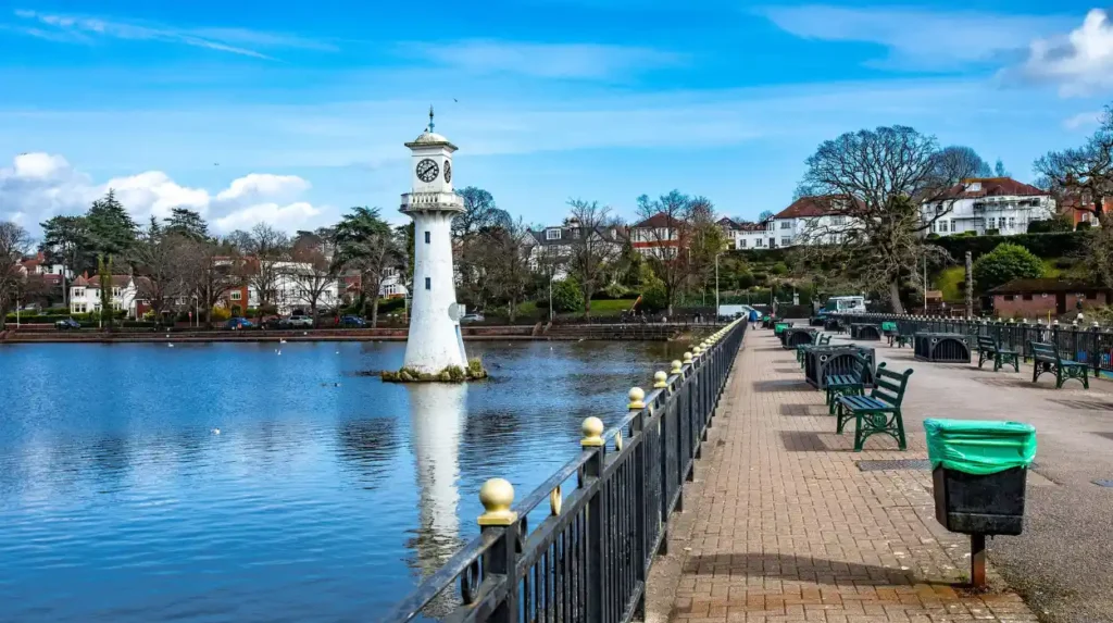
Roath Park reinforced Victorian Roath by providing a large planned public landscape alongside new residential streets. Created between 1887 and 1894, it combined recreation, planting, water, education and public health within Cardiff’s expanding eastern suburb.
Roath Park is one of the strongest physical expressions of late-Victorian Cardiff.
The land was donated to Cardiff in 1887, with the 3rd Marquess of Bute playing the central role. Other landowners also contributed land. The resulting park covered about 120 acres.
Cadw designated Roath Park as a Grade I registered historic park and garden in 2022. Cadw describes it as an important late-Victorian public park retaining much of its original framework.
The park was designed between 1887 and 1894. Its original purpose included recreation, sport, education and access to fresh air.
The first section opened to the public on 20 June 1894.
Roath Park also influenced surrounding housing.
Cadw records that the park retains its historic setting of surrounding villa residences built to benefit from its presence and particularly from views towards the lake.
The relationship between park and housing demonstrates an important Victorian planning principle: attractive public landscapes increased the value and desirability of nearby residential development.
Why did Victorian Roath contain both terraces and villas?
Roath contained terraces and villas because the expanding suburb served different social and economic groups. Smaller terraces housed working and lower-middle-class families, while larger villas provided spacious accommodation for wealthier professionals, merchants and established families.
Victorian Cardiff had a socially varied population.
Industrial expansion created demand for workers at different occupational levels. Engineers, clerks, tradespeople, teachers, professionals, merchants and industrial workers all required housing.
Roath’s estate system accommodated this diversity.
Terraced streets provided relatively compact housing. Larger houses appeared on selected streets where landowners targeted wealthier residents.
Wordsworth Avenue is an early example of planned higher-status housing. The street was designed as a tree-lined residential retreat with larger family houses.
The areas around Roath Park later developed villa housing that benefited from the park setting.
This social diversity became part of Roath’s long-term identity.
The suburb was not created for one occupational group. It became a mixed residential district linked to the wider Cardiff economy.
How did churches, schools and businesses complete Victorian Roath?
Victorian Roath required institutions as well as houses. Churches, schools, shops, public houses and other services developed alongside residential streets, creating self-contained neighbourhoods that supported daily life within the expanding suburb.
Residential expansion created demand for local services.
Churches were especially important in Victorian urban development. St Margaret’s Church of Antioch was built in 1870 in Gothic Revival style on the site of an earlier chapel. The church was designed by John Prichard and associated with the Marquess of Bute.
Commercial development followed population growth.
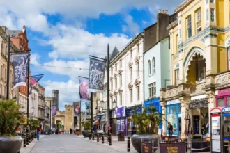
City Road and Albany Road became important commercial corridors. Shops provided food, clothing, household goods and services close to residential areas.
Public houses also formed part of the commercial landscape.
The Roath Park Hotel provides a surviving example of late-Victorian commercial development. Cardiff Council’s Local Development Plan heritage material dates the building to around 1886 and links its development with the Mackintosh Estate.
Schools and community institutions also became necessary as family populations increased.
The result was a suburb that functioned as more than a collection of houses.
How did Cardiff’s wider industrial economy shape Roath?
Cardiff’s industrial economy shaped Roath by generating employment, migration, investment and demand for housing. The growth of docks, coal exports, engineering and commercial services transformed surrounding farmland into a large residential district during the Victorian period.
The relationship between Roath and Cardiff’s port economy was fundamental.
Cardiff’s docks expanded to handle South Wales coal. The Roath Basin opened in 1874, followed by the Roath Dock in 1887. Historical research into Cardiff’s industrial development records the increasing pressure on the Bute Docks and the construction of additional dock facilities during the late nineteenth century.
Industrial growth produced direct and indirect employment.
Dock workers needed homes. Engineers needed homes. Railway workers needed homes. Shopkeepers serving expanding communities needed homes.
Builders, brickmakers, carpenters, plumbers and other construction workers also benefited from the housing boom.
Roath therefore developed as part of a wider economic system.
The district was residential in physical appearance, but its growth depended on the industrial and commercial transformation of Cardiff.
Why did transport matter to Victorian Roath?
Transport mattered because roads and railways connected Roath with Cardiff’s centre, docks and wider employment areas. Improved movement supported suburban expansion by allowing residents, workers, goods and services to circulate across the growing city.
Newport Road was particularly significant.
It was an established route into Cardiff from the east and became a major corridor for suburban development. Housing spread outward along important routes before filling the spaces between them.
Rail transport also became part of Cardiff’s wider urban structure.
Roath eventually had a railway station on the South Wales Main Line, although the station closed in 1917.
The broader railway network connected Cardiff with industrial districts, ports and surrounding communities.
Transport infrastructure did not simply follow suburban development. It also reinforced the value of land for housing and commercial activity.
This relationship remains visible today. Cardiff Council’s current transport planning still identifies connections between the city centre, Roath Park, Plasnewydd and Penylan as important parts of the city’s active-travel network.
What architectural features reveal Roath’s Victorian past?
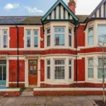
Roath’s Victorian character survives through repeated architectural features including red brick façades, slate roofs, bay windows, sash windows, decorative entrances, terraces, villas, chimneys and formal street layouts associated with nineteenth-century residential development.
The surviving built environment provides physical evidence of the development process.
Terraced houses reveal the density required by rapid population growth. Larger villas reveal the presence of wealthier residents. Commercial buildings reveal the emergence of local shopping streets.
Street geometry also matters.
Regular building lines and repeated house types demonstrate planned estate development rather than random construction.
Roath’s conservation areas and heritage assessments help protect this historic character. Cardiff Council lists Roath Park and Roath Mill Gardens among areas covered by conservation documentation.
The buildings are therefore part of a wider historical landscape.
Their significance comes from their relationship with streets, gardens, parks, institutions and commercial corridors.
Why is Roath described as Victorian Cardiff?
Roath is described as Victorian Cardiff because its modern urban form was largely created during Queen Victoria’s reign. Rapid population growth, estate housing, municipal expansion, public parks and industrial prosperity established the physical and social structure that still defines the district.
The term “Victorian Cardiff” refers to the city’s dramatic nineteenth-century expansion under Queen Victoria, whose reign lasted from 1837 to 1901.
Roath fits this definition particularly strongly.
Its population rose from roughly 300 in the early 1850s to more than 61,000 by 1901.
Its streets expanded through estate development.
Its administrative status changed when Roath became part of Cardiff in 1875.
Its public infrastructure expanded alongside population growth.
Its late-Victorian identity was strengthened by Roath Park, opened in 1894.
Its houses, churches and commercial streets created an urban landscape that survived into the twentieth and twenty-first centuries.
Roath therefore represents one of the clearest examples of how industrial-era Cardiff converted rural land into a large Victorian suburb.
Explore More Area Guide
Story Behind Adamsdown: Cardiff’s History 2026
How Pontcanna Got Its Name: Cardiff History
How does Victorian Roath influence Cardiff today?
Victorian Roath continues to influence Cardiff through its housing stock, street network, parks, conservation areas, commercial corridors and cultural identity. Modern residents still use infrastructure and public spaces established during the district’s nineteenth-century urban expansion.
The legacy is visible throughout the area.
Victorian terraces continue to provide homes. Former estate roads remain major routes. Commercial streets continue to support local businesses. Roath Park remains a major public green space.
Cardiff University also describes Roath as a district with a strong history, diverse community, urban character and proximity to the city centre and university campuses.
The historic relationship between Roath and Cardiff’s centre also remains important.
Modern transport projects continue to improve connections between the city centre, Roath Park, Plasnewydd and Penylan. Cardiff Council’s Cycleway 6 specifically connects the city centre with these eastern districts.
The Victorian street pattern therefore remains relevant to twenty-first-century urban planning.
What is the historical significance of Roath’s Victorian transformation?
Roath’s Victorian transformation demonstrates how industrialisation changed Cardiff’s geography. A small rural parish became a major residential district through population growth, private estate development, municipal incorporation, infrastructure investment and public-space planning.
The transformation was driven by several connected forces.
Cardiff’s port economy created employment.
Population growth created housing demand.
Landowners released agricultural land for development.
Builders constructed terraces and villas.
Local government regulated streets and public health.
Cardiff’s expanding municipal authority coordinated infrastructure.
Roath Park introduced a major public landscape.
Churches, schools and businesses created neighbourhood services.
These processes produced the urban Roath recognised today.
The historical record shows that the district’s Victorian identity was not the result of one building or one development scheme. It emerged from decades of coordinated and market-driven change.
The most important evidence is the physical landscape itself. Victorian streets, surviving houses, public institutions, commercial corridors and Roath Park preserve the structure of the nineteenth-century suburb.
Roath became Victorian Cardiff because Cardiff’s industrial expansion required a new urban landscape, and Roath provided the land, location and estate structure needed to build it.
Why did Roath become part of Victorian Cardiff?
Roath became part of Victorian Cardiff because the city’s industrial and population growth created strong demand for new housing. Cardiff’s expanding docks, coal trade, employment and infrastructure encouraged residential development across previously rural land.