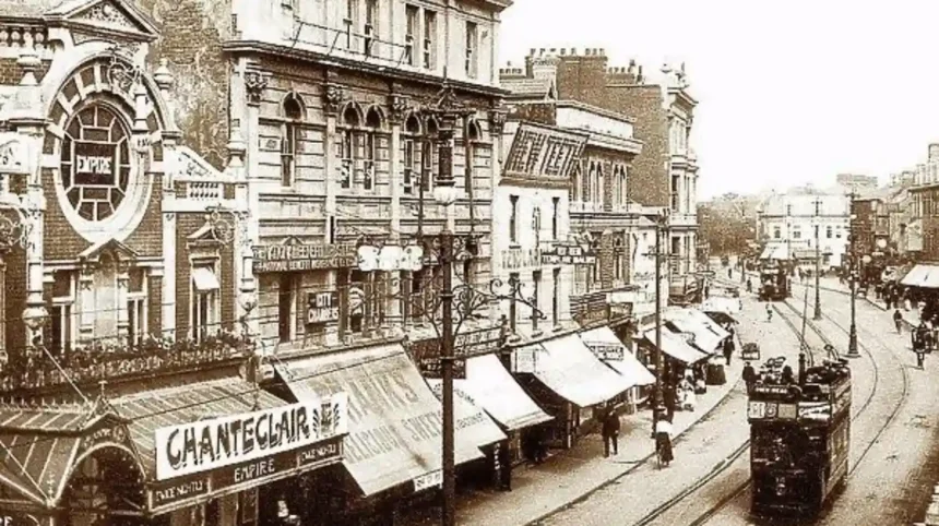
Cardiff’s historic tram routes formed one of the most important public transport networks in the city between the late 19th century and the middle of the 20th century. The system began with horse-drawn trams in 1872 and developed into an electric municipal network that connected the city centre with Cardiff Docks, Roath, Canton, Victoria Park, Grangetown, Cathays, Gabalfa and Roath Park.
- When did Cardiff’s tram network begin?
- Which historic Cardiff tram routes connected the city centre?
- How did Cardiff’s horse tram routes develop before electrification?
- Why did Cardiff introduce electric trams?
- Which Cardiff streets still reveal the old tram network?
- How far did Cardiff’s electric tram network extend?
- What role did Cardiff Docks play in the historic tram network?
- How did historic trams serve Roath and Roath Park?
- How did Cardiff trams serve Canton and Victoria Park?
- What happened to Cardiff’s tram routes after the 1930s?
- Why were Cardiff’s historic tram routes important to urban development?
- What evidence survives of Cardiff’s historic tram routes?
- Can Cardiff’s historic tram routes still be traced today?
- How does Cardiff’s historic tram system relate to modern tram plans?
- What is the historical legacy of Cardiff’s tram routes?
The tram network reflected Cardiff’s rapid industrial growth. Cardiff became a major coal-exporting port during the Victorian period, creating strong demand for reliable movement between residential districts, commercial streets, railway facilities and the docks. Tram routes provided that connection before motor buses became dominant.
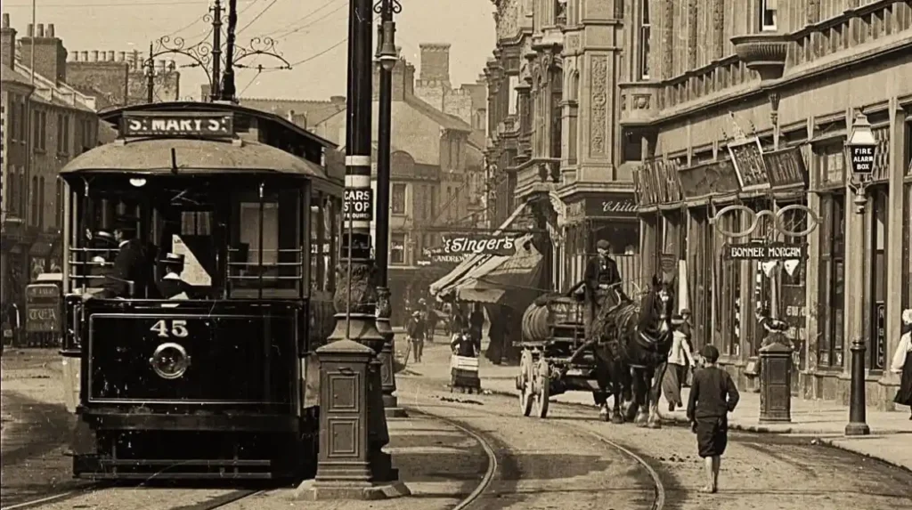
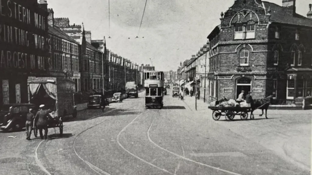
Cardiff Corporation Tramways operated the main electric system from 1902 until February 1950. At its maximum extent, the network covered about 19.5 route miles, or 31.3 kilometres, and operated 142 tramcars in 1928. Historical photographs preserved by the National Library of Wales show tram tracks and vehicles on streets including City Road, Newport Road, Lower Cowbridge Road and North Road.
When did Cardiff’s tram network begin?
Cardiff’s tram network began in 1872 with horse-drawn services operated by the Cardiff Tramways Company. The first route linked the city centre around High Street with Cardiff Docks, establishing a transport connection between central Cardiff and its expanding port economy.
The first Cardiff tram service opened on 12 July 1872. The original system used horse-drawn vehicles running on standard-gauge tracks. The first route connected Bute Docks Pier Head with High Street, placing the developing docklands within direct reach of the commercial centre.
The timing was significant. Cardiff’s docks were expanding rapidly because of the South Wales coal trade. Workers, merchants, sailors, dock employees and shoppers needed transport across a city that was growing beyond its historic core.
Additional routes followed during the 1870s. A route from High Street towards Roath developed through The Hayes and Queen Street. A western route reached Canton, while other lines extended towards Clarence Road and Cathays. These early routes established the basic east-west and north-south structure that later electric tram services developed.
Horse trams remained an important part of Cardiff transport for several decades. The Cardiff Tramways Company operated open-top double-deck vehicles and maintained depots to support the network.
The early network was privately operated. That changed at the beginning of the 20th century when Cardiff County Borough Council obtained Parliamentary powers to take control of the city’s tramways and develop an electric system.
The National Library of Wales preserves records relating to Cardiff tramways and associated legislation. Its archive includes documentation concerning Cardiff Corporation Tramways extensions under the Tramways Act 1870 framework.
Which historic Cardiff tram routes connected the city centre?
Historic Cardiff tram routes radiated from the city centre towards major residential, commercial and industrial districts. Important corridors reached Roath, Canton, Cardiff Docks, Grangetown, Cathays, Gabalfa, Roath Park and Victoria Park, creating a connected municipal network.
The city centre functioned as the central interchange point for many historic routes. High Street, The Hayes, Queen Street and surrounding streets formed the commercial heart of the network.
The eastern corridor connected central Cardiff with Roath. Roath was becoming increasingly urbanised during the Victorian and Edwardian periods, making public transport important for residents travelling into the commercial centre.
Another route extended towards Cardiff Docks. This connection reflected the economic importance of the port. The docks were among the principal destinations for workers and commercial traffic.
The western network served Canton and Victoria Park. Canton developed as a major residential and commercial district west of the city centre. Victoria Park became an important destination and western terminus for tram services.
Northwards, tram routes reached Cathays and later Gabalfa. Cathays was transformed by urban expansion and the growth of educational institutions, housing and civic development.
The network also extended towards Roath Park. The route through Penylan connected the city centre with the park and surrounding residential areas.
The maximum system therefore had a radial structure. Routes moved outward from central Cardiff rather than forming a separate suburban railway network. The surviving historical description of the Cardiff Corporation system identifies major lines running east to Roath, southeast to Roath Dock, south to the Pier Head, Clarence Road and Clive Street in Grangetown, west to Victoria Park, northwest towards Llandaff Fields, and north towards Gabalfa and Roath Park.
How did Cardiff’s horse tram routes develop before electrification?
Cardiff’s horse tram routes expanded from the original 1872 city-centre-to-docks service into several corridors serving Roath, Canton, Cathays and southern Cardiff. The network established transport patterns that later electric tramways retained and expanded.
The first horse tram route connected Bute Docks Pier Head and High Street.
Later in 1872, a route extended eastwards from High Street through The Hayes and Queen Street towards Roath. In 1879, the Roath route was extended farther east.
A western route to Canton was also developed during the 1870s. Canton became increasingly important as Cardiff expanded westwards.
A southern route reached Clarence Road. Another route headed north towards Cathays through Salisbury Road.
These routes were not simply transport lines. They corresponded with the physical growth of Cardiff. Residential development followed major roads, while commercial activity concentrated around accessible streets and transport junctions.
The Cardiff Tramways Company operated 52 horse tramcars when the council began taking over the system in 1902. The municipal takeover represented a major change in the organisation of Cardiff public transport.
Another horse tramway company operated the Cardiff District and Penarth Harbour Tramways. Despite its name, that system did not actually reach Penarth. It ran between Clifton Street in Roath and Clive Street in Grangetown. Cardiff Corporation took control of this route in February 1903 for reconstruction and conversion.
The horse-tram period therefore provided the foundation for Cardiff’s later electric network.
Why did Cardiff introduce electric trams?
Cardiff introduced electric trams to modernise public transport, increase capacity and operate a larger municipal network across a rapidly expanding city. Cardiff County Borough Council secured Parliamentary powers in 1898 and began electric tram operations in 1902.
The Cardiff Corporation Act 1898 gave Cardiff County Borough Council powers to take over existing tramways and develop electric traction. The change placed the principal tram system under municipal control.
Electric traction provided advantages over horse traction. Electric trams could operate without teams of horses, reduced the logistical requirements associated with animal-powered transport and supported higher-volume urban services.
The first electric Cardiff Corporation tram routes formally opened in May 1902. Electricity was supplied from the Cardiff power station at Roath, close to the tram depot.
The transition happened in stages. Cardiff Corporation took over the Cardiff Tramways Company system in January 1902, while the final horse tram services continued during the conversion period. The last horse services associated with the main system ended in October 1902.
The Cardiff District and Penarth Harbour Tramways were taken over in February 1903. This allowed the corporation to rebuild and integrate another important cross-city corridor.
Municipal control also allowed Cardiff to coordinate tram infrastructure with broader urban planning and electricity generation.
Which Cardiff streets still reveal the old tram network?
Historic tram routes can still be understood through Cardiff’s surviving street pattern, although the tracks themselves have largely disappeared. City Road, Newport Road, Lower Cowbridge Road, North Road, Charles Street and other historic corridors retain documentary evidence of tram-era transport.
The National Library of Wales holds an important photographic record of Cardiff streets during the tram era.
A photograph of City Road from around 1905 shows tramlines running along the street beside shops. Another image records a No. 21 tram on City Road.
Newport Road is also represented in the archive. A circa-1905 postcard shows a tram operating on Newport Road.
Lower Cowbridge Road contains another important photographic record. The National Library of Wales identifies an image taken near the junction with Norfolk Street.
North Road also appears in the collection. The historical image shows the street alongside a canal or river and provides evidence of the urban landscape through which Cardiff’s tram network operated.
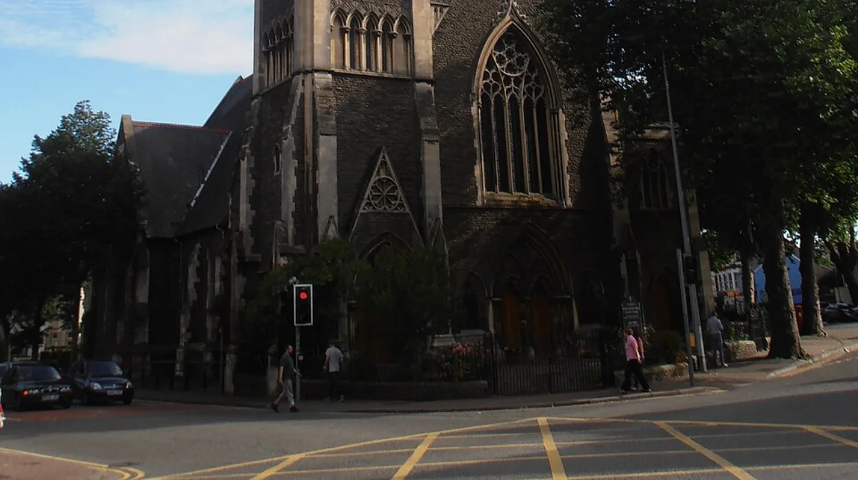
Charles Street and the area around St David’s Church provide further evidence of tram-era central Cardiff.
These photographs are valuable because they document more than vehicles. They show track positioning, road widths, shops, buildings, pedestrians and the relationship between tram infrastructure and everyday urban life.
The archive therefore provides a way to trace historic Cardiff tram corridors even where modern road layouts have changed.
How far did Cardiff’s electric tram network extend?
Cardiff’s electric tram network reached approximately 19.5 route miles at its maximum, connecting western, eastern, northern and southern districts. By 1929, its reach included Victoria Park, Grangetown, Cardiff Docks, Roath, Splott and Gabalfa.
The network reached its maximum route length at approximately 19.51 miles, equivalent to about 31.3 kilometres.
The 1928 network operated 142 tramcars. Passenger use was substantial, with approximately 42.44 million passenger journeys recorded during the year ending 31 March 1928. Tramcars covered about 3.49 million car miles during that period.
The network had developed considerably from the original horse tram route.
By 1929, the system extended from Victoria Park in the west to Grangetown and Cardiff Docks in the south, Roath and Splott in the east, and Gabalfa in the north.
This geographic coverage demonstrates the role of trams in connecting different types of urban district.
Victoria Park represented the western edge of the system.
Grangetown connected southern residential areas with the city centre.
Cardiff Docks represented the industrial and maritime economy.
Roath and Splott represented eastern residential and industrial growth.
Gabalfa provided a northern connection.
Roath Park formed another important northern destination through the Penylan corridor.
The system therefore connected employment, housing, recreation and commerce within one municipal transport network.
What role did Cardiff Docks play in the historic tram network?
Cardiff Docks were central to the historic tram network because the port generated large volumes of employment and commercial activity. Tram routes connected dock areas with the city centre and surrounding residential districts, supporting movement through industrial Cardiff.
Cardiff’s industrial economy shaped the geography of public transport.
The docks handled coal exports and supported large numbers of workers. Reliable transport between the docks and residential districts was therefore essential.
The original 1872 tram route directly connected Bute Docks Pier Head with High Street. This relationship between port and city centre continued after electrification.
The electric system also served Cardiff Docks and associated streets. The corporation’s network concentrated heavily on routes serving the docks during its early years.
The importance of dock traffic is reflected in passenger figures. Cardiff recorded more than 23 million tram passengers in 1904, compared with more than 18 million in the previous year.
The tramway was therefore closely connected with Cardiff’s industrial expansion.
The relationship also explains why southern routes towards Grangetown, Clarence Road and dock areas were significant components of the network.
How did historic trams serve Roath and Roath Park?
Roath and Roath Park formed important eastern and northeastern destinations within Cardiff’s tram network. Electric routes connected these areas with the city centre, while Penylan provided a route towards Roath Park and surrounding residential districts.
Roath was one of the principal eastern destinations of Cardiff’s tram system.
The route from central Cardiff through Queen Street towards Roath originated during the horse-tram period. It was later incorporated into the electric network.
Roath’s development was closely associated with Cardiff’s late-19th and early-20th-century expansion. Residential streets, shops and industrial activity created sustained demand for public transport.
Roath Park represented a different type of destination. Opened in stages from the late 19th century, the park became a major recreational space.
The tram route towards Roath Park ran through Penylan. This gave residents and visitors a direct public transport connection between central Cardiff and one of the city’s major green spaces.
The historic network therefore served both everyday commuting and leisure journeys.
The National Library of Wales photographic collections also preserve evidence of Cardiff’s early 20th-century tram-era streetscape, providing visual records for researchers examining how routes interacted with neighbourhood development.
How did Cardiff trams serve Canton and Victoria Park?
Canton and Victoria Park formed the principal western part of Cardiff’s tram network. Tram services linked these areas with central Cardiff and provided public transport for residential communities, commercial streets and recreational destinations west of the historic city centre.
Canton was one of the earliest areas connected by Cardiff horse trams.
The western route from High Street to Canton was developed during the 1870s. Electric trams later continued the connection as Cardiff Corporation expanded and modernised its network.
Victoria Park became the western terminus of the electric system.
The route demonstrated the geographical reach of Cardiff’s municipal transport system. A passenger could travel from central Cardiff towards the western residential districts and Victoria Park using an electric tram.
The western corridor also connected with broader routes through Canton and towards Llandaff.
This created a transport relationship between residential Cardiff, recreational spaces and the city centre.
The route is particularly important for understanding the way Cardiff developed beyond its historic medieval core. Tramways provided the transport infrastructure required to connect new neighbourhoods with established commercial areas.
What happened to Cardiff’s tram routes after the 1930s?
Cardiff’s tram network entered decline during the 1930s as the council increasingly shifted towards motor buses and trolleybuses. Tram replacement began during the Second World War, and the final Cardiff tram service ended in February 1950.
Cardiff Corporation introduced its own motor bus service in 1920. The growth of buses created a new form of competition for tramways.
The tram network still carried large numbers of passengers during the late 1920s, but the council began closing routes where renewal costs and operational limitations made tram replacement attractive.
The first tram route closure occurred on Salisbury Road in January 1930. Further closures followed during the 1930s.
In May 1939, Cardiff Corporation formally decided to abandon the tramway system. The transition was interrupted by the conditions of the Second World War, but the long-term policy remained focused on replacement.
Trolleybuses began replacing tramcars in 1942.
The final tram service operated in February 1950. The closure marked the end of Cardiff’s electric street tram era after nearly five decades of municipal electric operation and almost 78 years after the first horse tram service.
Historical sources differ slightly on the precise final operating date, with records commonly identifying February 1950 and the final service as 19 February 1950.
Why were Cardiff’s historic tram routes important to urban development?
Cardiff’s historic tram routes influenced urban growth by connecting residential districts, workplaces, shopping streets, docks and parks. The network supported Cardiff’s expansion from a compact commercial centre into a larger industrial and residential city.
Transport infrastructure and urban development were closely connected.
Cardiff’s population and built-up area expanded rapidly during the industrial era. Tram routes provided a practical method of moving people across increasing distances.
The relationship between trams and housing was particularly important. Areas such as Roath, Canton, Grangetown and Cathays became easier to reach from the central commercial district.
Industrial districts also depended on reliable transport. Cardiff Docks, Roath Dock and surrounding industrial areas required connections with residential communities.
The network also supported leisure destinations. Victoria Park and Roath Park were connected to central Cardiff through tram corridors.
The result was a city with a more integrated transport geography.
Modern Cardiff still reflects some of these historical development patterns. Major roads that once carried tram tracks continue to function as important movement corridors.
Although the tracks have disappeared, the streets remain part of Cardiff’s urban structure.
What evidence survives of Cardiff’s historic tram routes?
Evidence of Cardiff’s historic tram routes survives in photographs, archival documents, transport records, legislation, street patterns and preserved tram equipment. These sources allow researchers to reconstruct routes, vehicles, infrastructure and the historical development of Cardiff’s public transport.
The National Library of Wales is one of the most important sources for visual evidence.
Its archive contains photographs of Cardiff streets from around 1905, including City Road, Newport Road, Lower Cowbridge Road, North Road, Charles Street and The Hayes.
The archive also contains documents relating directly to Cardiff Corporation Tramways and tramway extensions.
Parliamentary legislation provides another category of evidence. The Cardiff Corporation Act 1898 established the legal framework for municipal control and electric tram development.
Transport historians also use tramway maps, timetables, tickets, vehicle records, municipal reports and contemporary newspapers to reconstruct the system.
Preserved vehicles provide physical evidence of the technology. Cardiff Corporation Tramways water car 131 is preserved at the National Tramway Museum, demonstrating that components of the municipal tram era survive outside the modern Cardiff street network.
These sources are particularly valuable because historic route information often differs between operating periods. A street served by trams in 1905 did not necessarily have the same route, destination or service pattern in 1930.
Historical tram research therefore requires attention to individual dates.
Can Cardiff’s historic tram routes still be traced today?
Cardiff’s historic tram routes can still be traced through surviving road corridors, neighbourhood names, archival photographs and historical maps, although the original electric tram infrastructure has disappeared from most streets. Current streets preserve much of the network’s geographical footprint.
Modern Cardiff does not operate the historic street tram network.
However, many former tram corridors remain major roads.
City Road remains an important east-central Cardiff corridor.
Newport Road continues to provide a major eastern connection.
Cowbridge Road remains a significant western transport corridor.
Routes towards Canton, Roath, Cathays, Grangetown and other historic tram-served districts continue to structure Cardiff’s urban geography.
The physical rails have largely disappeared, but the roads that carried them often remain.
Historic photographs allow present-day streets to be compared with their tram-era appearance. The National Library of Wales collection is particularly useful because several Cardiff images show tramlines directly in the road surface.
A modern walking or heritage research route can therefore combine present-day streets with archival imagery to understand how Cardiff’s transport network changed.
Explore More Area Guide
Lost Buildings of Roath: Cardiff’s Forgotten Historic Sites
Forgotten Industries That Built Cardiff’s Industrial Legacy
How does Cardiff’s historic tram system relate to modern tram plans?
Cardiff’s historic tram network forms part of a longer public transport history that now includes new tramway and tram-train proposals. Modern projects use different technology and infrastructure, but they again place rail-based urban transport at the centre of Cardiff’s transport planning.
Cardiff is once again developing tramway infrastructure.
Cardiff Council and Transport for Wales are working on Cardiff Crossrail, a modern tramway and tram-train project intended to improve connections between Cardiff Central and Cardiff Bay.
The current Cardiff Crossrail Phase 1A scheme includes a new stop near Cardiff Central, a tramway through Callaghan Square and a connection with the existing Cardiff Bay railway corridor. Cardiff Council states that enabling works began in June 2026 and the main construction phase is scheduled to begin in July 2026.
The modern scheme is not a direct reconstruction of Cardiff Corporation Tramways.
The historic system used electric street-running tramcars on a network that reached about 19.5 route miles at its peak. The modern Cardiff Crossrail proposal uses contemporary tram-train infrastructure and integration with the existing rail network.
The connection is nevertheless historically significant.
Cardiff has repeatedly used rail-based public transport to connect the city centre with residential communities, commercial districts and the waterfront.
The historic tram network demonstrates how transport infrastructure responded to Cardiff’s industrial expansion. Modern tramway proposals respond to contemporary priorities including connectivity, public transport capacity and urban development.
Cardiff’s tram history therefore remains relevant to understanding the city’s transport geography.
What is the historical legacy of Cardiff’s tram routes?
Cardiff’s historic tram routes created a city-wide transport structure that connected industrial docks, residential neighbourhoods, commercial streets and public parks. Their legacy survives through street layouts, neighbourhood development, archival records and renewed investment in urban rail transport.
Cardiff’s tram era lasted from the first horse tram in 1872 until the final electric tram service in 1950.
During that period, the city changed from an expanding Victorian industrial centre into a major Welsh city.
The tram network was central to that transformation.
Its routes linked High Street and the central commercial area with Cardiff Docks, Roath, Canton, Victoria Park, Grangetown, Cathays, Gabalfa, Splott and Roath Park.
At its peak, the electric network covered approximately 19.5 route miles and operated 142 tramcars.
The system carried tens of millions of passengers annually during its strongest period.
Its closure did not erase its geographical influence. Many roads that once carried tramcars remain important transport corridors.
The surviving photographs and documents also provide a detailed record of Cardiff’s urban landscape during the tram era.
For modern Cardiff, the history has additional relevance because new tramway and tram-train schemes are again being developed. Cardiff Crossrail demonstrates that rail-based urban transport remains part of the city’s long-term transport planning.
Cardiff’s historic tram routes are therefore more than a record of obsolete vehicles. They form an important part of the city’s industrial, social, architectural and transport history.
Understanding the routes explains how Cardiff expanded, how people moved between neighbourhoods and workplaces, and why certain roads became major urban corridors.
The rails have gone, but much of the geographical framework created by Cardiff’s historic tram system remains visible in the modern city.
What was the first tram route in Cardiff?
The first Cardiff tram service began in 1872. The original horse-drawn route connected Bute Docks Pier Head with High Street, linking Cardiff’s growing docklands with the city centre.