Splott is one of Cardiff’s most historically distinctive inner-city communities. Its identity has changed from rural farmland to Victorian industrial suburb, then from a steelmaking neighbourhood to a post-industrial residential district with new community, environmental and regeneration priorities.
- How did Splott develop before becoming an urban Cardiff neighbourhood?
- How did the nineteenth century transform Splott?
- Why did Victorian terraced housing become central to Splott’s identity?
- How did the East Moors steelworks change Splott?
- How did community life develop during Splott’s industrial decades?
- How did the twentieth century change Splott’s industrial identity?
- What happened to Splott after the steelworks closed?
- How has Splott’s identity changed in the twenty-first century?
- How is transport shaping the future identity of Splott?
- What does Splott’s changing identity reveal about Cardiff?
The story of Splott is closely connected with Cardiff’s wider transformation. The area sits east of Cardiff city centre, close to Roath, Tremorfa, Cardiff Docks and the East Moors industrial area. Its location placed it at the centre of major changes in housing, transport, employment and urban development.
Understanding the changing identity of Splott requires a long historical view. The area existed as named land centuries before its streets were built. Victorian Cardiff transformed that landscape through industrial expansion. The twentieth century brought steelmaking, community growth, war, redevelopment and industrial decline. The twenty-first century has added regeneration, environmental projects, changing housing patterns and improved public spaces.
Today, Splott retains physical evidence from several periods. Victorian terraces, surviving community buildings, parks, industrial sites and newer developments all contribute to its character. The district therefore represents a layered part of Cardiff rather than a neighbourhood defined by a single historical period.
How did Splott develop before becoming an urban Cardiff neighbourhood?
Splott began as rural agricultural land associated with Upper and Lower Splott Farms, long before Victorian urbanisation. Medieval records identify the place by name, while farming, estate ownership, marshland and coastal geography shaped its landscape before Cardiff’s industrial expansion transformed it permanently.
The name Splott is centuries older than the modern residential district. Historical records identify the area as agricultural land associated with the Bawdrip family and later the Tredegar Estate. Upper Splott Farm and Lower Splott Farm formed important parts of the pre-industrial landscape.
The surrounding eastern Cardiff landscape contained low-lying and marshy land. Its proximity to the River Rhymney and the Bristol Channel influenced drainage and land use. Agricultural activity remained important until Cardiff’s nineteenth-century expansion changed the economic value of the area.
Historical research records several early references to Splott. The Roath Local History Society documents historical forms of the name, including “Splot” in medieval and early modern records. The precise linguistic origin of the name remains debated, but its historical existence is firmly established.
The rural landscape began changing as Cardiff expanded eastwards. New roads, transport infrastructure and industrial activity gradually reduced the separation between Cardiff and the surrounding farms.
This transition was not immediate. Agriculture continued alongside early development. The emergence of residential streets therefore represents a gradual replacement of rural land rather than a sudden change.
The history of early Splott establishes an important foundation for understanding the neighbourhood. Its industrial identity developed later. The original landscape was agricultural, estate-managed and connected to Cardiff’s coastal geography.
How did the nineteenth century transform Splott?
The nineteenth century transformed Splott through Cardiff’s rapid industrial expansion. Growing coal exports, dock construction, railway development and nearby iron and steel production created employment and housing demand, turning agricultural land into a densely populated working-class suburb connected directly to Cardiff’s industrial economy.
Cardiff’s industrial growth accelerated during the nineteenth century. Coal from the South Wales Valleys moved through Cardiff towards international markets. The Glamorganshire Canal connected Cardiff with Merthyr Tydfil in 1794, while the Taff Vale Railway opened in 1841.
The expansion of Cardiff Docks strengthened this industrial system. Roath Dock opened in 1887 and Queen Alexandra Dock opened in 1907. Cardiff’s coal exports reached nearly 11 million tonnes in 1913, demonstrating the scale of the port economy.
Splott was positioned close to this expanding industrial network. Its eastern location provided convenient access to docks, railway infrastructure and industrial employment.
The economic transformation created intense demand for housing. Workers needed accommodation near factories, railways and docks. Land that had previously supported agriculture became increasingly valuable for residential development.
The resulting urbanisation changed the physical structure of Splott. Fields were replaced by streets. Farms were surrounded by terraces. New schools, chapels, churches, shops and public houses followed the growing population.
The industrialisation of Splott therefore involved several connected processes. Employment attracted workers. Workers required homes. Homes required services. Services created a permanent community.
Cardiff’s industrial history also explains why Splott developed differently from many affluent suburban areas. Its built environment was closely associated with working-class employment and high-density residential construction.
The district became an important part of the wider industrial city rather than an isolated suburb.
Why did Victorian terraced housing become central to Splott’s identity?
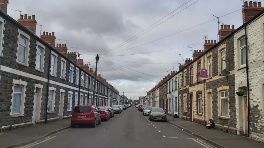
Victorian terraced housing became central to Splott because rapid industrial growth created demand for affordable homes close to employment. Repeated rows of houses allowed large numbers of workers and families to settle near docks, railways and steelworks, creating the dense neighbourhood still visible today.
Large-scale housing development accelerated during the late nineteenth century. The Tredegar Estate played a significant role in urbanising its land around Splott.
The Roath Local History Society records extensive development of Tredegar land and describes how streets, churches, chapels, mission halls, schools and institutes emerged alongside housing. These institutions helped create a strong working-class community.
The architectural form reflected the economic structure of industrial Cardiff. Terraced homes provided efficient use of land and created continuous residential streets.
Splott’s housing was also closely connected with employment. Residents could reach industrial workplaces, docks, workshops and commercial premises without living far from the city centre.
The growth was rapid enough to attract contemporary attention. Cardiff heritage research records a reported Splott population of 10,183 in 1893, illustrating the scale of the district’s late nineteenth-century expansion.
Housing became more than physical accommodation. The streets created neighbourhood networks. Families lived close to relatives, neighbours and local institutions. Shops and public houses operated within walking distance of homes.
This physical closeness contributed to Splott’s community identity.
The built environment also created a strong visual distinction from the former agricultural landscape. Rows of houses, paved streets and public buildings replaced fields and farm buildings.
Much of Splott’s historical character remains visible through this housing stock. Although some streets have disappeared through later redevelopment, substantial areas of Victorian and Edwardian housing remain important to the district’s identity.
How did the East Moors steelworks change Splott?
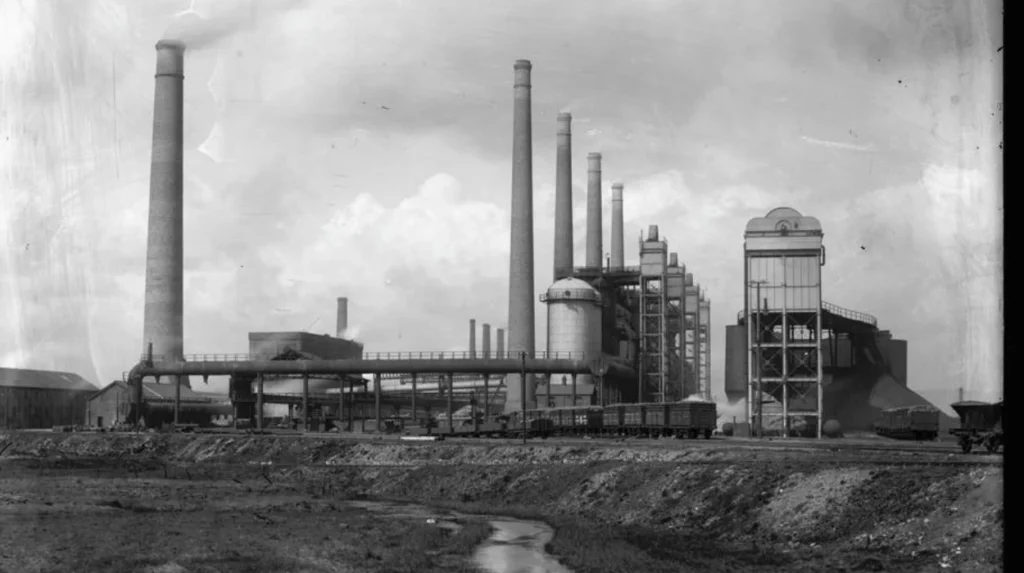
The East Moors steelworks strengthened Splott’s industrial identity by creating large-scale employment close to residential streets. Its connection with Cardiff Docks, railways and imported raw materials made the area part of an integrated steelmaking landscape that shaped local employment and community life.
The Dowlais-Cardiff Steel Works was constructed on Cardiff East Moors and opened in stages between 1891 and 1895. The works were located close to Cardiff Docks because imported iron ore could arrive through the port.
The works later became known as East Moors Works. It remained an important industrial presence until closure in 1978.
Its influence extended beyond factory employment. Industrial workplaces affected housing demand, transport patterns, local businesses and household incomes.
The steelworks also reinforced the connection between Splott and the wider South Wales industrial economy. Raw materials arrived through the docks. Railways transported industrial goods. Workers lived in surrounding communities. Finished products entered national and international markets.
Splott therefore became part of an industrial chain extending from Welsh coalfields and ironworks to Cardiff Docks and global markets.
Museum Wales records the importance of railways to South Wales industry. Steam locomotives transported coal and steel towards Cardiff, Barry and Newport docks, linking industrial production with maritime export.
The physical presence of East Moors also influenced local identity. Industrial structures, railway lines, chimneys and factory activity formed part of the everyday environment.
The steelworks became one of the defining symbols of twentieth-century Splott.
Its closure later produced an equally important transformation. The disappearance of major industrial employment changed the economic foundation of the district and accelerated the transition towards a post-industrial identity.
How did community life develop during Splott’s industrial decades?
Community life expanded alongside industrial employment through schools, churches, chapels, parks, public houses, shops and sports organisations. These institutions gave Splott a social structure that extended beyond workplaces and helped establish a durable neighbourhood identity across the twentieth century.
Industrial communities require more than employment and housing. Splott developed a wide network of institutions serving residents.
Religious buildings represented different traditions within the expanding population. Baptist, Independent, Methodist, Anglican and Roman Catholic institutions all contributed to local community life.
Education became another important part of the district. Schools served children living in the rapidly expanding residential streets.
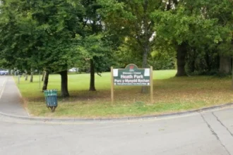
Splott Park became especially significant. The park opened in 1901 after land was provided to Cardiff Corporation by Lord Tredegar. Facilities developed over subsequent years, including a bandstand, cricket pitches, playground, bowling green and tennis courts.
The park became an important public space within a densely built neighbourhood.
Its role demonstrates how municipal investment changed the quality and structure of urban life. Residents had access to recreation without travelling into central Cardiff.
Community identity also developed through local commerce. Shops and public houses served daily needs. Markets later became another important feature of the district.
Splott’s social identity was therefore created through repeated interaction between residents and local institutions.
The strength of these networks became particularly important during periods of economic change. When industrial employment declined, community institutions remained part of the neighbourhood’s social infrastructure.
This distinction matters when examining Splott today. The area’s identity did not disappear when the steelworks closed. Its residential streets, schools, parks and community organisations provided continuity.
How did the twentieth century change Splott’s industrial identity?
The twentieth century changed Splott from a rapidly expanding industrial suburb into a mature working-class community before heavy industry declined. War, post-war redevelopment, changing employment patterns and the closure of East Moors Works reshaped the area and removed much of its industrial landscape.
The first half of the twentieth century continued Splott’s close relationship with Cardiff’s industrial economy.
Cardiff remained a major port. Coal, steel and maritime employment influenced the city’s eastern districts.
The First World War and Second World War brought additional pressures. Industrial production became strategically important, while residents experienced wider national changes in employment, transport and housing.
After the Second World War, Cardiff entered a period of major urban restructuring.
Industrial land use changed. Some older streets and buildings were cleared. Housing policies altered the composition of communities across the city.
Lower Splott experienced particularly significant physical change. Seventeen former streets were eventually lost through redevelopment, according to reporting by ITV Wales based on residents’ memories and historical evidence.
The disappearance of these streets represents more than architectural change. Streets contained homes, relationships, shops and memories. Their removal altered the physical geography of the community.
The closure of East Moors Works in 1978 marked another major turning point.
The Senedd’s exhibition on Cardiff photographs from 1969 to 1977 documents Splott during the period when the steelworks was closing and the area was being redeveloped. The photographs record physical decay and major changes experienced by long-term residents.
The industrial identity that had dominated Splott for generations therefore weakened rapidly during the 1970s.
The neighbourhood entered its post-industrial phase.
What happened to Splott after the steelworks closed?
After East Moors Works closed in 1978, Splott entered a post-industrial period. Large industrial sites were removed or repurposed, some residential streets disappeared, and employment patterns changed, while the surviving Victorian neighbourhood remained an important foundation of local identity.
Industrial closure affected both the economy and landscape.
Large factory sites no longer dominated the eastern Cardiff skyline. Employment shifted towards other sectors as Cardiff’s economy changed.
Some former industrial land became commercial, residential or infrastructure sites. Other areas remained associated with workshops and business activity.
Cardiff Council continues to operate Splott Workshops on Portmanmoor Road, demonstrating the persistence of employment and business activity within the district’s post-industrial landscape. The council lists Splott Workshops among its business starter and workshop locations.
The physical survival of older housing became increasingly important.
Terraced streets provided continuity with the industrial past. Former industrial buildings and transport routes added further historical evidence.
Splott Market also became a notable part of the post-industrial commercial landscape. The market operated from its site east of Cardiff city centre from 1980 and became an established local trading institution.
The changing economy did not eliminate local commerce. Instead, the commercial structure adapted to new conditions.
This period also changed how Splott was viewed within Cardiff. The district moved from being primarily identified with steelmaking and docks towards being recognised as a residential inner-city community facing the wider challenges of post-industrial urban areas.
The identity remained strongly local.
How has Splott’s identity changed in the twenty-first century?
Twenty-first-century Splott combines industrial heritage with residential life, community projects, environmental initiatives, business activity and urban regeneration. The area retains Victorian housing and historical institutions while new projects address public space, food growing, recreation, transport, economic activity and neighbourhood renewal.
The modern identity of Splott contains several historical layers.
Its Victorian terraces remain visible. Former industrial land continues to influence the layout of the area. Splott Park remains a major public space. Community organisations continue to operate alongside newer businesses and projects.
Environmental initiatives have become increasingly important.
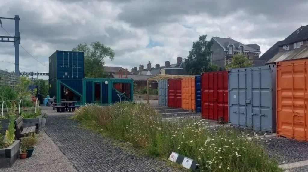
Railway Gardens provides a clear example. The Welsh Government describes the project as a community food-growing hub created from a former derelict playground in Splott. The project includes raised beds, fruit trees, a greenhouse, polytunnel, pond and habitat features.
The project demonstrates a shift in land use. Space that was previously unused has become community infrastructure supporting food growing, biodiversity and social activity.
The Welsh Government records around 1,200 informal visits to Railway Gardens each year, alongside regular gardening, after-school and community activities.
Splott Park has also received modern investment. In 2025, Cardiff Council announced the reopening of its redesigned playground. The redevelopment included accessible equipment and a train-themed design referencing Jessie, a 1937 steam locomotive that served at East Moors steelworks until 1965.
This project directly connects modern recreation with industrial heritage.
The result is a new form of historical identity. Splott is not preserving its industrial past only through museums or monuments. Elements of that past appear within contemporary public spaces.
The neighbourhood therefore combines preservation with practical regeneration.
Explore More Area Guide
What Makes Pontcanna Different? Cardiff Neighbourhood Guide 2026
Why People Love Living in Penylan, Cardiff 2026
How is transport shaping the future identity of Splott?
Transport remains important to Splott because its historic identity developed around railways, docks and industrial movement. Modern Cardiff transport planning continues this connection through proposed Metro expansion, cycling infrastructure and improved public transport links serving the city’s eastern neighbourhoods.
Transport has shaped Splott throughout its history.
Railways helped Cardiff move coal, steel and other goods. Their routes influenced industrial development and housing. Modern transport continues to affect the district’s relationship with central Cardiff and surrounding communities.
Cardiff Council’s transport planning identifies a future Metro station at Splott as part of the planned Cardiff Circle tram-train line. The council’s published transport timeline lists the Splott station alongside other proposed Metro stations for 2028.
The proposed transport investment reflects the changing role of the neighbourhood.
Historic transport infrastructure primarily served industrial movement. Modern infrastructure focuses more strongly on passenger mobility, sustainable travel and connections between residential communities and employment centres.
Cycling is also part of Cardiff’s wider transport strategy. Cardiff Council has planned segregated cycling routes as part of its citywide transport programme.
These changes can influence how Splott connects with the city centre, Cardiff Bay, Roath and other eastern districts.
The transport story therefore continues the historical pattern of change.
Splott’s future identity will remain influenced by accessibility. Its location close to central Cardiff gives transport investment particular importance.
What does Splott’s changing identity reveal about Cardiff?
Splott’s changing identity reflects Cardiff’s wider transformation from an agricultural and port-based landscape into an industrial city and then a modern service-oriented capital. Its history shows how employment, housing, transport, regeneration and community institutions repeatedly reshape urban neighbourhoods.
Splott provides a concentrated record of Cardiff’s urban development.
Its earliest identity was rural. Farms and estate ownership dominated the landscape.
Its Victorian identity was industrial. Housing expanded because Cardiff’s docks, railways, factories and steelworks generated employment.
Its twentieth-century identity was shaped by mature community life and industrial employment. Schools, parks, churches, shops and sports facilities gave the district a permanent social structure.
Its late twentieth-century identity became post-industrial. East Moors Works closed in 1978, industrial land changed use and several residential streets disappeared.
Its twenty-first-century identity is more diverse. Residential life continues alongside business activity, environmental projects, public-space investment and planned transport improvements.
This sequence explains why Splott remains historically significant.
The district demonstrates that neighbourhood identity is created through physical structures and social relationships. Houses, streets, workplaces, parks, schools and transport routes all influence how a place develops.
The historical record also demonstrates that change is continuous.
Cardiff itself has undergone major transformation. Museum Wales records that the city became one of the world’s leading coal-exporting ports, with more than 10 million tons passing through Cardiff in 1913.
That industrial economy shaped Splott directly.
When the economy changed, the neighbourhood changed with it.
Today, regeneration does not erase this history. Projects such as Railway Gardens and the redevelopment of Splott Park demonstrate how contemporary investment can incorporate local heritage into new forms of community infrastructure.
The future identity of Splott will therefore be based on both continuity and change.
Its Victorian terraces preserve the residential history of industrial Cardiff. Its former industrial sites preserve evidence of steelmaking. Its parks and community projects reflect current priorities. Planned transport improvements connect the district with Cardiff’s future urban structure.
Splott is consequently best understood as a layered Cardiff neighbourhood.
Its identity has never been static. It has moved from farms to factories, from steelworks to post-industrial land, and from an industrial workforce community to a contemporary inner-city district.
That long process explains why Splott remains an important part of Cardiff’s history and its ongoing urban development.
What is Splott known for?
Splott is known for its Victorian terraced housing, industrial heritage, community facilities and connection with Cardiff’s former docks and East Moors steelworks. Its identity developed through industrialisation and continued changing after heavy industry declined.