Cardiff is shaped by waterways that are no longer visible in their original form. Beneath roads, beside modern buildings, through parks, and around Cardiff’s docklands are traces of a canal system that helped transform the city from a relatively small port into a major industrial centre.
- What were the hidden canals beneath Cardiff?
- Why was the Glamorganshire Canal built?
- How did the Glamorganshire Canal change Cardiff?
- Where did the old Cardiff canals run?
- Which parts of Cardiff still show evidence of the canals?
- Why was Cardiff’s canal system covered and closed?
- What was the Dock Feeder Canal used for?
- How can visitors find Cardiff’s hidden canal history today?
- What do Cardiff’s hidden canals reveal about the city’s history?
- Why are Cardiff’s hidden canals still important today?
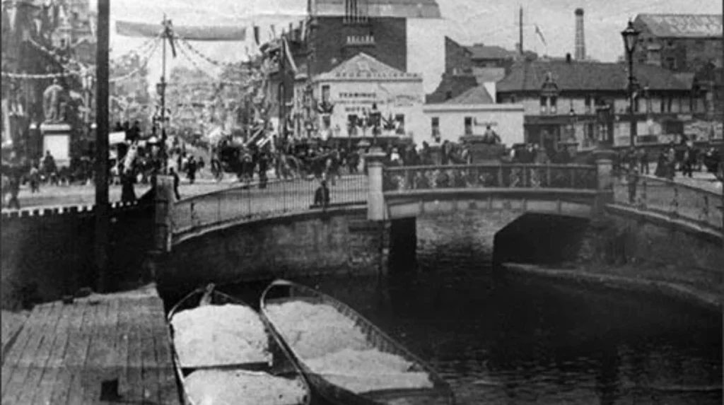
The most important historic waterway was the Glamorganshire Canal, opened in 1794 to connect the industrial communities around Merthyr Tydfil with Cardiff. The canal carried iron and later coal towards Cardiff for export. Its route extended for about 25.5 miles and originally descended through around 50 locks. A southern extension reached the Bristol Channel through Cardiff in 1798.
A second important waterway was the Dock Feeder Canal, developed in the 1830s to supply Cardiff’s expanding docks with water. Parts of this system remain visible today, including sections through Bute Park and the city centre. Other sections were covered by roads and later reopened as heritage and public-realm projects.
The result is a hidden layer of Cardiff’s industrial landscape. Streets, pedestrian routes, parks and waterfront spaces occupy land once associated with navigation, locks, towpaths, basins and dock infrastructure.
What were the hidden canals beneath Cardiff?
Cardiff’s hidden canals were historic industrial waterways whose routes were later filled, covered, altered, or incorporated into modern infrastructure. The main examples are the Glamorganshire Canal and Dock Feeder Canal, which connected the city with South Wales industry and its expanding docks.
The term “hidden canals” does not describe one continuous underground canal running beneath modern Cardiff. It describes surviving evidence and buried or covered sections of historic waterways.
The Glamorganshire Canal was the principal industrial canal. It was authorised by Parliament in 1790 and constructed to improve the movement of goods between the iron-producing districts around Merthyr Tydfil and Cardiff. The National Library of Wales preserves records relating to the 1790 Act and subsequent amendments to the canal scheme.
The canal reached Cardiff in 1794. A southern extension and sea-lock system opened in 1798, providing a connection towards the Bristol Channel. The Royal Commission on the Ancient and Historical Monuments of Wales records the main canal as approximately 25.5 miles long.
The Dock Feeder Canal was a separate but connected piece of infrastructure. It was developed to provide water for Cardiff’s docks. The feeder took water from the River Taff around Blackweir and carried it towards the dock system.
Modern Cardiff therefore contains several different layers of historic water infrastructure. Some waterways remain open. Others survive as archaeological features. Some were incorporated into roads or pedestrian routes. Others disappeared beneath later development.
Why was the Glamorganshire Canal built?
The Glamorganshire Canal was built to transport iron, coal and other industrial materials from South Wales valleys to Cardiff more efficiently. Its construction responded to industrial expansion around Merthyr Tydfil and the need for reliable access to Cardiff’s port and overseas markets.
Before the canal, moving heavy industrial materials overland was slower and more expensive. The ironworks around Merthyr Tydfil required dependable transport connections for raw materials and finished products.
The canal was promoted by major industrial interests in the Merthyr area. Cadw identifies the Glamorganshire Canal as an important product of the Industrial Revolution in Wales and records its role in moving goods towards Cardiff.
The 1790 Act authorised construction of a navigable canal between Merthyr Tydfil and Cardiff. National Library of Wales archival material identifies the legislation as 30 Geo. III, chapter 82, dated 1790.
Construction created a navigable route through the Taff valley. The completed canal used locks to manage the substantial difference in elevation between the industrial valleys and Cardiff.
The first cargoes were closely associated with the iron industry. Cardiff Bay Heritage records that the first load of iron reached Cardiff by canal in February 1794.
The canal therefore formed part of a much larger industrial system. Ironworks, quarries, tramroads, warehouses, wharves, docks and ships were connected through transport infrastructure.
How did the Glamorganshire Canal change Cardiff?
The Glamorganshire Canal accelerated Cardiff’s industrial growth by connecting the town directly with the South Wales iron-producing districts. Its traffic increased the importance of Cardiff as an export port and created pressure for larger dock facilities during the nineteenth century.
The canal changed the economic geography of Cardiff. Goods from the valleys could reach the port through a dedicated water route rather than depending entirely on roads and other overland transport.
The canal’s arrival coincided with major industrial growth in South Wales. Cardiff became increasingly important as an export centre, particularly as coal production expanded.
Coflein records that Cardiff grew rapidly from the 1830s and became a major port for coal from the Cynon, Rhondda and Rhymney valleys. Between 1840 and 1870, the city experienced exceptionally rapid expansion associated with the coal-export economy.
The original canal terminus and sea connection eventually proved inadequate for the scale of maritime trade. Cardiff needed larger docks capable of handling more vessels and greater cargo volumes.
The response included the development of the Bute West Dock, which opened in 1839. The dock provided a much larger enclosed water space for shipping and formed part of the expanding Cardiff Docks complex. Coflein records that Bute West Dock enclosed approximately 7.7 hectares.
Bute East Dock followed in 1859, while Roath Dock opened in 1887 and Queen Alexandra Dock opened in 1907. These developments demonstrate how the original canal-supported port evolved into a much larger dock system.
Where did the old Cardiff canals run?
The historic Glamorganshire Canal followed the Taff valley from Merthyr Tydfil towards Cardiff, while the Cardiff section connected with the city’s dock and sea-lock system. The Dock Feeder followed a different route through central Cardiff and Bute Park towards the docks.
The Glamorganshire Canal followed the general corridor of the River Taff. Its northern end was associated with Merthyr Tydfil and its southern destination was Cardiff.
The route passed through industrial communities including Abercynon, Pontypridd and areas north of Cardiff. Coflein records the canal as descending originally through 50 locks, with additional branches including the Aberdare Canal.
The Cardiff end is particularly important when researching the city’s hidden waterways. The canal reached the port area before the large nineteenth-century dock system transformed Cardiff’s waterfront.
A sea-pound and sea-lock extension provided direct access towards the Bristol Channel. This infrastructure became increasingly important as Cardiff’s export economy expanded.
The Dock Feeder followed another route. Cardiff Council describes it as a waterway developed in the 1830s to supply the docks from the River Taff around Blackweir.
Its route passed through or alongside areas now associated with Bute Park and central Cardiff. Coflein records that the Dock Feeder forms part of the eastern boundary of Bute Park and that sections of earlier mill-leat infrastructure were later reused for the feeder.
This explains why historic waterways can appear in unexpected locations across modern Cardiff.
Which parts of Cardiff still show evidence of the canals?
Historic canal evidence survives in several parts of Cardiff, including Bute Park, the Dock Feeder route, former canal alignments, pedestrian underpasses and Cardiff Bay. Some sections remain open as water while others survive below roads, within landscapes, or as archaeological traces.
Bute Park is one of the clearest places to understand Cardiff’s water infrastructure. The Dock Feeder runs along the park’s eastern side, providing a visible connection between the modern landscape and nineteenth-century dock engineering.
The history is older than the Dock Feeder itself. Archaeological assessment of Bute Park identified a mill leat associated with medieval corn mills. Much of that leat was later reused as part of the Dock Feeder system.
This creates several chronological layers in the same landscape. Medieval water management preceded nineteenth-century industrial engineering, which was later followed by modern urban development.
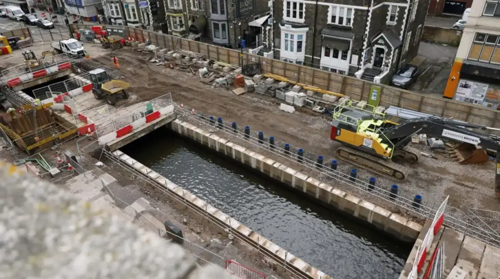
Another important location is the central Cardiff section around Churchill Way. Cardiff Council reopened a previously covered section of the Dock Feeder in 2023. The project removed 69 concrete beams from the covered waterway and exposed the canal again.
The reopened section also has a modern drainage function. Cardiff Council stated that associated rain gardens divert approximately 3,700 square metres of water away from the sewage system each year.
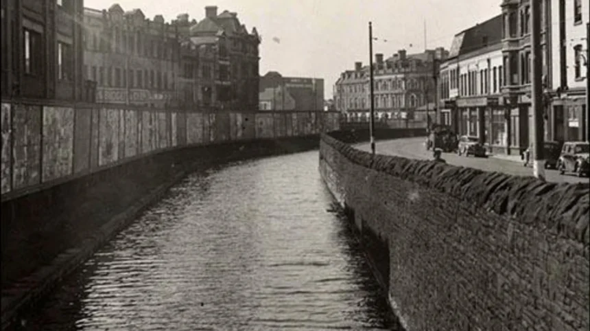
Other traces survive around the former canal corridor. The Glamorganshire Canal itself was progressively closed in sections and much of its Cardiff route disappeared beneath later infrastructure.
Coflein records that the Pontypridd-to-Cardiff section closed in 1942 and that the Cardiff sea-pound closed in 1951. The remaining canal landscape was subsequently altered by roads and redevelopment.
Why was Cardiff’s canal system covered and closed?
Cardiff’s canals declined because railways, roads and expanding urban development provided faster and more flexible transport. The Glamorganshire Canal closed progressively from 1898, with the final Cardiff sea-pound closing in 1951 after decades of declining canal use.
The canal system was highly effective during the early Industrial Revolution, but its competitive position changed as railway transport expanded.
The Taff Vale Railway opened in 1840 and provided a direct railway connection between the industrial valleys and Cardiff. Rail transport offered significant advantages for large-scale coal and industrial cargoes.
Cadw identifies the development of railways as one of the major changes that transformed transport in Wales during the nineteenth century. The Taff railway was developed specifically to move coal and iron from the valleys.
The Glamorganshire Canal therefore faced increasing competition.
The canal did not close all at once. Coflein records a staged decline: the Merthyr-to-Abercynon section closed in 1898, the Abercynon-to-Pontypridd section closed in 1915, and the Pontypridd-to-Cardiff section closed in 1942. The Cardiff sea-pound remained until 1951.
Urban development then changed the physical appearance of the old canal corridor.
Cardiff Council records that the Glamorganshire Canal in the city was covered between 1948 and 1950. Parts of the former waterway subsequently became incorporated into modern transport infrastructure.
The disappearance of the canal from the visible city therefore resulted from two connected processes. The first was the decline of canal transport. The second was the redevelopment of the land occupied by the former waterway.
What was the Dock Feeder Canal used for?
The Dock Feeder Canal supplied water to Cardiff’s docks and helped maintain operational water levels. It supported dock access at different tidal conditions, provided water for dock management and became an important engineering connection between the River Taff and Cardiff’s expanding dock system.
The Dock Feeder was essential to the operation of Cardiff’s nineteenth-century docks.
Cardiff’s docks needed controlled water levels because tidal conditions affected access. The feeder brought water from the River Taff into the dock system.
Cardiff Council states that the Dock Feeder was constructed to maintain the water level in Bute docks and enable dock operations around the clock. It also supplied water used to flush silt from dock entrances.
This function explains why the feeder was strategically important even though it was not primarily designed for cargo navigation.
The waterway also had an earlier history. Cardiff Council records that part of the upper route between Blackweir and Fishers Bridge originated as a mill stream. The stream powered a mill before being incorporated into the later dock-water infrastructure.
The Dock Feeder also interacted with other historic structures. The Cardiff Council history trail records that plans to route the feeder through a tunnel under St Mary Street were abandoned because of engineering difficulties. An aqueduct was instead constructed near the North Road entrance to Bute Park.
This is an important distinction when exploring Cardiff’s “hidden canals”. Not every underground-looking feature represents a buried canal. Some are former channels, covered sections, culverts, aqueducts, mill leats or later adaptations of earlier waterways.
How can visitors find Cardiff’s hidden canal history today?
Visitors can trace Cardiff’s hidden canal history through Bute Park, the Dock Feeder, central Cardiff, former canal alignments and Cardiff Bay. Historic maps, heritage trails, archaeological records and surviving water features help identify waterways that modern streets have concealed.
Bute Park provides one of the clearest starting points because the Dock Feeder remains visible within the landscape. Its position alongside the park creates a direct physical connection between historic water engineering and the modern city.
Central Cardiff provides another important location. The reopened Dock Feeder section at Churchill Way demonstrates how buried infrastructure can become visible again through regeneration projects.
Cardiff Bay provides the wider historical context. The docks developed because the original canal and port infrastructure could not accommodate the growing scale of industrial exports.
The historic relationship between the canal and docks is documented by Coflein. The Glamorganshire Canal brought iron from Merthyr Tydfil towards Cardiff, while the rapid growth of the port subsequently required larger dock facilities.
Visitors interested in deeper research can also use historical maps and archival collections. The National Library of Wales holds extensive canal-related records, including nineteenth-century Glamorganshire Canal Company material.
The Glamorgan Archives also holds substantial material relating to Cardiff and the wider historic county. Cadw states that the archive contains more than 12 kilometres of documents covering the region from the twelfth century to the present.
Historical mapping is particularly useful because modern streets often obscure former waterways. Comparing older maps with contemporary Cardiff reveals changes in canal alignments, docks, basins, roads and industrial land.
Explore More Area Guide
Cardiff During the Industrial Revolution: Coal, Docks and Railways
Former Villages Absorbed Into Cardiff: A History
What do Cardiff’s hidden canals reveal about the city’s history?
Cardiff’s hidden canals reveal how industrial transport reshaped the city. The waterways connected South Wales ironworks and coalfields with international markets, encouraged dock expansion, influenced urban development and left archaeological and landscape features beneath today’s roads, parks and public spaces.
The canals are evidence of Cardiff’s transformation during the Industrial Revolution.
The city’s development was closely connected to the natural resources of the South Wales valleys. Iron, coal and other materials required efficient routes to markets. The canal provided one of the earliest large-scale transport solutions.
The canal system also demonstrates the relationship between infrastructure and urban growth. Cardiff’s increasing industrial importance created demand for larger docks. West Bute Dock opened in 1839, followed by additional docks as coal exports expanded.
The city’s modern waterfront therefore developed from a sequence of engineering projects rather than a single transformation.
The waterways also demonstrate changing technology. Canals dominated heavy transport during the early Industrial Revolution. Railways then became increasingly important. Roads and motor transport later transformed the landscape again.
The physical disappearance of the canal does not mean its historical influence disappeared. Former canal corridors helped determine the position of roads, pedestrian routes, parks and later developments.
The Dock Feeder provides a particularly strong example. Its surviving sections continue to function as water infrastructure while also serving as historic landscape features.
Modern regeneration has also brought sections of this hidden infrastructure back into public view. The Churchill Way project demonstrated how a covered waterway can become part of contemporary urban design while retaining its historic identity.
Why are Cardiff’s hidden canals still important today?
Cardiff’s hidden canals remain important because they preserve evidence of industrialisation, transport engineering, dock development and urban change. Surviving waterways and buried alignments provide historical information while supporting heritage interpretation, archaeological research, environmental management and modern regeneration.
The surviving canal landscape has both historical and practical significance.
From a heritage perspective, the waterways explain how Cardiff became an industrial port. The National Library of Wales holds documentary evidence of the canal companies, legislation and commercial arrangements that shaped the system.
From an archaeological perspective, buried canal alignments can preserve evidence of historic engineering. Canal walls, lock structures, towpaths, culverts, bridges and associated industrial sites provide information about the construction and operation of the system.
From an environmental perspective, open water infrastructure remains relevant to drainage and water management. The modern Dock Feeder project at Churchill Way demonstrates this connection. The associated rain gardens were designed to manage surface water while improving the surrounding public realm.
The canals also strengthen understanding of Cardiff’s relationship with the wider South Wales industrial landscape. The Glamorganshire Canal was not an isolated Cardiff feature. It connected Cardiff with Merthyr Tydfil, Pontypridd and other industrial communities along the Taff corridor.
This wider perspective is essential. Cardiff’s port development depended on the movement of resources from the valleys, while industrial communities depended on access to markets through Cardiff.
Today, the hidden canal network survives in different forms. Some sections remain visible as open water. Some routes are incorporated into parks and walking corridors. Some are covered by roads. Others survive primarily through maps, archival records and archaeological evidence.
The result is a layered urban landscape in which modern Cardiff sits directly above and alongside infrastructure created during the Industrial Revolution.
The story of Cardiff’s hidden canals is therefore not simply the story of waterways that disappeared. It is the story of how transport technology, industrial production, maritime trade and urban development changed the physical structure of the Welsh capital.
Understanding the Glamorganshire Canal and Dock Feeder makes modern Cardiff easier to read. Roads, parks, waterfronts and public spaces become evidence of earlier engineering decisions.
The hidden canals remain part of Cardiff’s historical geography, even where the water itself has disappeared.
Are there really hidden canals beneath Cardiff?
Yes. Cardiff contains sections and traces of historic waterways that were covered, filled, diverted, or incorporated into later urban infrastructure. The main historic systems are the Glamorganshire Canal and Dock Feeder Canal.