Cardiff’s historic bridges reflect the city’s development from a medieval settlement beside the River Taff into the capital of Wales and a major industrial port. The city sits around the Taff, Ely and Rhymney river systems, making bridges essential for movement between communities, roads, railways, docks and public spaces.
- Why are Cardiff’s bridges historically important?
- How did the River Taff influence Cardiff’s historic bridges?
- When was Cardiff Bridge on Cowbridge Road built?
- What is historic about the Old Ely Bridge?
- How did railways change Cardiff’s historic bridge network?
- What role did bridges play in Cardiff’s industrial growth?
- How are Cardiff’s historic bridges protected as heritage structures?
- Which Cardiff bridge areas are important for understanding the city’s history?
- How can visitors explore Cardiff’s historic bridges?
- Why do Cardiff’s historic bridges remain relevant today?
The history of Cardiff’s bridges is closely connected with transport. Medieval crossings supported local movement around Cardiff Castle and the town. Industrial-era bridges supported expanding roads, railways and coal traffic. Later structures connected Cardiff Bay with regenerated waterfront districts and neighbouring Penarth.
Several historic bridges in and around Cardiff retain visible architectural features from the nineteenth and early twentieth centuries. Others have been rebuilt while preserving important crossing points. Their histories show how Cardiff repeatedly adapted its infrastructure as population, industry, transport technology and urban development changed.
Why are Cardiff’s bridges historically important?
Cardiff’s historic bridges record the city’s expansion, transport development and relationship with its rivers. They connected medieval routes, industrial districts, railway networks, docks and modern neighbourhoods while adapting to changing traffic and engineering requirements.
Cardiff developed around waterways that shaped its physical growth. Museum Wales identifies the River Taff, River Ely and River Rhymney as three important rivers associated with the city. The Taff was particularly influential because Cardiff developed on its lower course near the Bristol Channel.
Before modern bridges existed, river crossings depended on fords, ferries and earlier structures. The growth of Cardiff increased the need for permanent crossings. Roads connecting the town with surrounding communities required bridges that could carry pedestrians, carts, coaches and eventually motor vehicles.
The nineteenth century brought a much larger infrastructure challenge. Cardiff expanded rapidly because coal from the South Wales valleys was transported towards Cardiff Docks for export. Museum Wales records that Cardiff became the world’s largest coal-exporting port, with more than 10 million tons passing through the port in 1913.
Bridges therefore became part of a wider transport system. Road bridges connected districts, while railway bridges carried lines serving industrial areas and docks.
The history of Cardiff’s bridges also demonstrates repeated reconstruction. A bridge did not necessarily remain unchanged after its original construction. Rising traffic, structural deterioration, flooding and changes in transport technology resulted in widening, rebuilding or replacement.
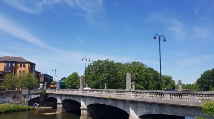
Cardiff Bridge on Cowbridge Road provides a clear example. The present structure dates from 1859, was widened in 1877 and substantially rebuilt in 1930–31. It replaced earlier bridges affected by flooding and changing transport requirements.
How did the River Taff influence Cardiff’s historic bridges?
The River Taff influenced Cardiff’s urban form by creating a major physical barrier between communities and transport routes. Bridges across the river enabled roads, railways and pedestrians to move between the city centre, western districts, parks, docks and later regenerated waterfront areas.
The Taff was central to Cardiff’s history. Medieval Cardiff developed beside the river, while Cardiff Castle occupied an important position close to the river crossing and settlement.
Museum Wales records that the River Taff strongly influenced medieval Cardiff’s shape. The river followed a different course before major nineteenth-century changes, and its relationship with the town influenced streets, quays and surrounding development.
As Cardiff expanded westward and northward, crossings became increasingly important. Roads needed reliable routes over the river, while railway development created additional crossings.
The industrial transformation of Cardiff intensified this requirement. The Glamorganshire Canal connected Cardiff with the South Wales industrial valleys from the late eighteenth century. The Taff Vale Railway followed in the nineteenth century, opening a major railway connection between Cardiff and the industrial valleys. Museum Wales records that the Taff Vale Railway opened in 1841, two years after the opening of Bute West Dock in 1839.
Railway infrastructure required substantial bridge construction. Railway bridges had to carry locomotives and rolling stock, creating different engineering requirements from traditional masonry road bridges.
The Taff also remained important as Cardiff moved from an industrial port economy towards a service, cultural and residential economy. Modern bridges continue to provide connections across the river, while older crossings remain part of the city’s historic landscape.

When was Cardiff Bridge on Cowbridge Road built?
The present Cardiff Bridge was constructed in 1859, widened in 1877 and substantially rebuilt in 1930–31. It replaced earlier bridges dating from 1796 and earlier crossings that were damaged or destroyed by flooding on the River Taff.
Cardiff Bridge is one of the clearest examples of how a historic crossing evolved through several construction phases.
The present bridge carries Cowbridge Road across the River Taff and forms part of an important route west from central Cardiff. Coflein records that the current structure has four low elliptical arches and a balustraded parapet.
The history of the crossing extends further back than the existing bridge. A bridge constructed in 1796 replaced an earlier bridge washed away in 1792. The 1796 structure itself stood slightly upstream and was washed away in 1827.
A new bridge was constructed in 1859. Traffic demands then resulted in widening in 1877. Major reconstruction followed in 1930–31.
This sequence demonstrates an important feature of Cardiff’s bridge history. Historic infrastructure often represents several generations of engineering rather than one unchanged structure.
The location was strategically important because Cowbridge Road connected Cardiff with western settlements. The route also supported movement towards Canton and areas beyond the Taff.
The surviving bridge therefore has both architectural and transport significance. Its four low elliptical arches demonstrate nineteenth-century masonry bridge construction, while its later rebuilding records the changing requirements of twentieth-century Cardiff.
For visitors interested in Cardiff’s industrial and transport history, the bridge is also useful because it sits within a wider landscape of nineteenth-century development on the western side of the Taff.
What is historic about the Old Ely Bridge?
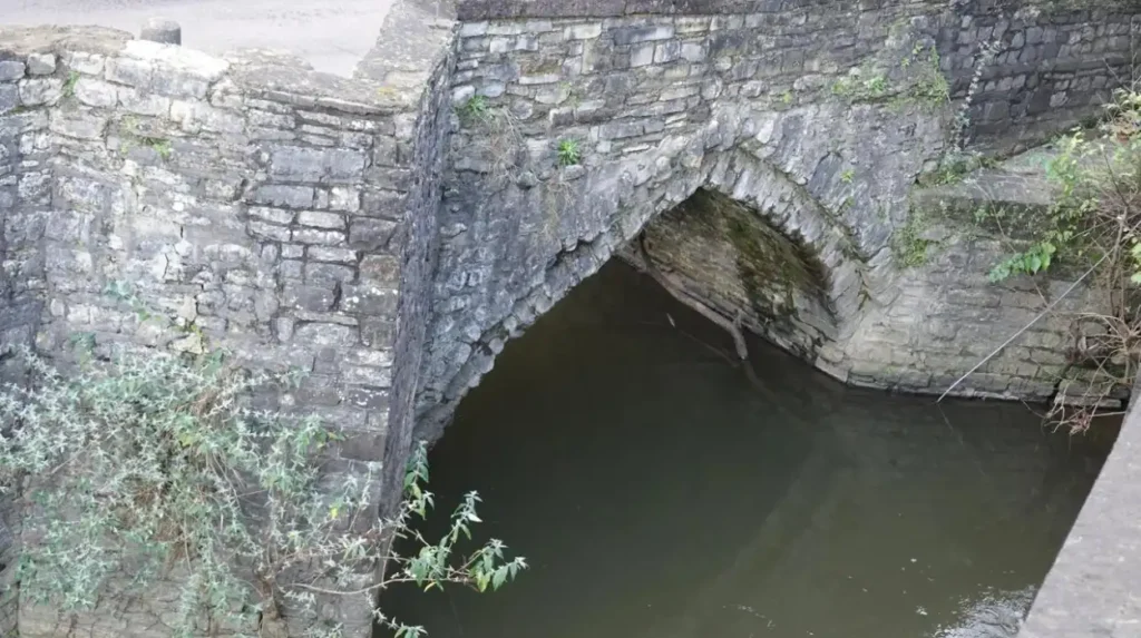
The Old Ely Bridge crossing has documented origins at least as early as 1536. The surviving stone structure has three arches, three cutwaters and parapet refuges, while a separate reinforced-concrete bridge opened beside it in 1935.
The historic crossing over the River Ely provides evidence of Cardiff’s much earlier road network.
Coflein records that a stone bridge existed at the site as early as 1536. The surviving historic structure is a three-arched bridge built from coursed stone. Its design includes three cutwaters, which protect the piers against river flow, and parapet refuges that provide additional space beside the roadway.
The bridge’s survival is particularly significant because modern traffic requirements eventually exceeded the capacity of the historic structure.
A reinforced-concrete single-arch bridge was opened alongside the old bridge in 1935. Modern traffic therefore moved onto the newer structure while the historic crossing remained as a visible record of the earlier road network.
The Old Ely Bridge demonstrates a recurring pattern in historic infrastructure. Instead of completely removing an old crossing, later engineering sometimes created a parallel structure.
This approach preserves evidence of earlier construction while providing a stronger and wider route for modern transport.
The River Ely also became increasingly important as Cardiff expanded towards Ely, Canton, Leckwith and the western side of the city. Its crossing points formed part of routes linking residential areas and the wider Vale of Glamorgan.
The bridge is therefore important not only because of its age but because it illustrates the transition from pre-industrial road engineering to twentieth-century reinforced-concrete infrastructure.
How did railways change Cardiff’s historic bridge network?
Railways transformed Cardiff’s bridge network during the nineteenth century by introducing structures designed for locomotives, heavier loads and dedicated transport corridors. Railway bridges connected Cardiff with industrial valleys, docks and stations while reinforcing the city’s role as a major coal-exporting port.
The railway transformed the scale of Cardiff’s transport infrastructure.
The Taff Vale Railway was particularly important. The railway connected Cardiff with the industrial valleys and provided an efficient route for transporting people and industrial goods.
The line was engineered by Isambard Kingdom Brunel and received Royal Assent in 1836. The Cardiff to Navigation House section opened in 1840, followed by the extension to Merthyr in 1841.
Railway development required bridges over roads, canals and waterways. Some railway crossings survive as important industrial archaeological structures.
Coflein records several historic railway bridges associated with the wider Cardiff transport network. These include bridges connected with the Taff Vale Railway and bridges crossing the Glamorganshire Canal.
The Glamorganshire Canal itself was an important predecessor to the railway system. Completed between Cardiff and the industrial valleys in the late eighteenth century, it created a water transport route for coal and iron.
Museum Wales records that the canal reached Cardiff in 1794 and connected the industrial economy of the valleys with Cardiff’s developing port.
Railways subsequently provided greater speed and capacity. Their bridges had to accommodate locomotives, railway gradients and dedicated track alignments.
Cardiff’s railway bridges therefore form part of a broader industrial landscape rather than isolated engineering features. They connect the history of the city centre with docks, industrial communities and the valleys north of Cardiff.
Some railway crossings are visually prominent, while others are incorporated into modern transport corridors. Their historic value lies in their role within the infrastructure that supported Cardiff’s industrial expansion.
What role did bridges play in Cardiff’s industrial growth?
Bridges supported Cardiff’s industrial growth by connecting coal-producing valleys, manufacturing districts, residential communities, railways, canals and docks. They enabled the movement of people and goods and became essential infrastructure during Cardiff’s transformation into a major nineteenth-century industrial port.
Cardiff’s industrial growth created pressure for continuous improvement in transportation.
The city’s docks were closely connected with the coal trade. The Glamorganshire Canal provided an early route from the valleys, while the Taff Vale Railway later strengthened Cardiff’s connection with industrial South Wales.
Bridges formed essential links within these networks.
Road bridges allowed carts and later vehicles to cross rivers and canals. Railway bridges allowed trains to cross roads and waterways without interrupting other transport. Canal bridges enabled roads and paths to cross navigable waterways.
The industrial importance of these structures becomes clearer when considered alongside Cardiff’s coal exports. Museum Wales records that coal exports reached millions of tonnes during the nineteenth century, with Cardiff becoming the largest coal-exporting port in the world and handling more than 10 million tons in 1913.
This economic expansion transformed the surrounding urban landscape.
The development of Bute Docks was central to this process. The 2nd Marquess of Bute opened Bute West Dock in 1839, followed by further dock development as Cardiff’s coal trade expanded.
Bridges connected the industrial city to its workforce and transport infrastructure.
Their importance also extended beyond freight. Residential districts expanded as employment opportunities increased, creating demand for dependable crossings for workers, pedestrians and commercial traffic.
The bridge network therefore supported both the movement of goods and the physical expansion of Cardiff.
How are Cardiff’s historic bridges protected as heritage structures?
Historic bridges in Wales can receive statutory heritage protection when they possess special architectural or historic interest. Cadw’s listing system covers structures including bridges, and protected structures require appropriate consent for changes that affect their historic character.
Heritage protection provides a framework for identifying and managing historically important structures.
Cadw explains that listing is the legal mechanism used to recognise buildings and structures of special architectural or historic interest in Wales. The term listed building includes structures such as walls, milestones and bridges as well as conventional buildings.
The current legal framework operates under the Historic Environment (Wales) Act 2023.
Listed status does not mean every historic bridge has the same level of protection or significance. The importance of an individual structure depends on its architectural, historical and archaeological characteristics.
Cardiff also has a wider conservation framework. Cardiff Council identifies 27 conservation areas across the city and around 1,000 listed buildings. The council also records around 300 locally listed buildings.
This broader heritage environment matters because bridges often form part of historic streetscapes rather than standing independently.
A bridge can be historically significant because of its design, construction date, association with transport history, relationship with surrounding buildings or role in the development of a particular district.
Coflein, maintained by the Royal Commission on the Ancient and Historical Monuments of Wales, provides detailed records for historic sites and structures. Its records document construction periods, architectural features, alterations and historical associations.
This documentation helps researchers distinguish original fabric from later modifications.
For Cardiff’s bridges, such records are particularly valuable because many crossings have undergone rebuilding, widening or replacement.
Which Cardiff bridge areas are important for understanding the city’s history?
Important bridge areas include crossings over the River Taff and River Ely, the historic routes around Cardiff Castle and Bute Park, industrial transport corridors, and Cardiff Bay. Together, these locations show how bridges supported medieval, industrial, twentieth-century and modern Cardiff.
Cardiff’s historic bridges are best understood as part of connected landscapes.
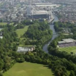
Bute Park provides an important example. The park occupies a historic area beside Cardiff Castle and the River Taff. Coflein identifies extensive archaeological and historical remains within the park, including medieval and post-medieval features and infrastructure associated with earlier water management.
The river crossing environment around central Cardiff also reflects the changing relationship between the city and the Taff.
Cardiff Bridge represents the western road network. The Old Ely Bridge represents the older route across the River Ely. Railway bridges represent the industrial transport system.
Cardiff Bay provides a later phase of bridge development.
The Cardiff Bay Barrage was completed in 1999 as a major civil engineering project. Cardiff Harbour Authority records that the barrage is 1.1 kilometres long and transformed the former tidal bay into a freshwater lake covering approximately 200 hectares.
The barrage incorporates locks, bridges, sluice gates and a fish pass. Three locks serve navigation, with each lock incorporating a bascule bridge. The structures allow movement between Cardiff Bay and the Severn Estuary while also supporting road, pedestrian and cycling access across the barrage.
Pont y Werin provides another modern crossing. The 140-metre bridge crosses the River Ely and connects Cardiff with Penarth for pedestrians and cyclists.
These newer structures are not nineteenth-century heritage bridges, but they are relevant to the continuing history of Cardiff’s crossings.
They show that bridge construction remains closely connected with changes in urban development, recreation, waterfront regeneration and sustainable transport.
Explore More Area Guide
Oldest Schools in Cardiff: Howell’s, Cathedral School & Cardiff High
Cardiff’s Longest Roads: A48, Newport Road and More
How can visitors explore Cardiff’s historic bridges?
Visitors can explore Cardiff’s bridges by combining river walks, historic streets, Bute Park, Cardiff Bay and the city’s western districts. Walking routes provide access to bridge viewpoints while connecting crossings with castles, parks, docks, railways and other historic landmarks.
Walking provides the clearest way to understand the relationship between bridges and Cardiff’s wider landscape.
Central Cardiff offers access to the River Taff, Cardiff Castle and Bute Park. Bute Park forms a substantial historic open space immediately beside the river and castle.
The Taff Trail also provides an important route for exploring the river corridor. Cadw describes an 8-kilometre cycle route from Bute Park towards Castell Coch, following the western bank of the River Taff before reaching the Grade I listed Victorian castle at Tongwynlais.
Cardiff Bay offers another distinct bridge landscape.
The Cardiff Bay Trail is approximately 10 kilometres long and is designed for walkers and cyclists. It crosses the Barrage and continues towards Penarth using Pont y Werin.
The route connects bridges with major waterfront landmarks including the Norwegian Church, Wales Millennium Centre and Senedd.
Visitors interested in historic transport should also look beyond individual bridges. Cardiff’s older road crossings, railway infrastructure, canals and dock-related structures form part of the same historical system.
The River Ely and River Taff corridors provide particularly useful opportunities to observe how old and new infrastructure exists together.
Modern bridge inspections also demonstrate that these structures remain active components of Cardiff’s transport network. Cardiff Harbour Authority issued a 2026 notice covering inspections of Penarth Road Bridge and Castle Street Bridge on the River Taff.
This continuing maintenance illustrates the practical requirement to preserve bridge infrastructure while maintaining public safety and navigation.
Why do Cardiff’s historic bridges remain relevant today?
Cardiff’s historic bridges remain relevant because they combine heritage, transport, architecture, engineering and urban development. Their continued presence helps explain how the city expanded around its rivers while modern crossings continue the long tradition of connecting communities and transport networks.
Cardiff’s bridges provide physical evidence of changing transport systems.
The earliest documented crossings supported local roads. Nineteenth-century bridges responded to industrialisation. Railway bridges supported the coal economy. Twentieth-century reconstructions accommodated motor traffic. Modern crossings support walking, cycling, waterfront regeneration and public access.
The historic value of bridges therefore extends beyond their construction dates.
A bridge such as Cardiff Bridge records repeated adaptation from the eighteenth century to the twentieth century. The Old Ely Bridge preserves a crossing documented from the sixteenth century while a 1935 concrete structure demonstrates later transport requirements.
Cardiff’s industrial history also gives its bridges wider significance. The city’s transformation into a major coal-exporting port depended on an extensive transport system connecting the valleys with docks and international shipping routes.
The modern city has different economic priorities, but the underlying geographic challenge remains.
Rivers still divide urban areas. Bridges still provide essential connections.
Cardiff Bay demonstrates this continuity particularly clearly. The Barrage combines engineering, navigation, flood and water-level management, pedestrian access and public space. Its bridges operate as part of a much larger infrastructure system.
Historic bridges also contribute to the interpretation of Cardiff’s identity. They help explain why roads developed in particular locations, why railway corridors followed certain routes and how communities became connected.
For heritage visitors, bridges provide practical starting points for exploring the city’s history. For residents, they remain functioning parts of everyday transport infrastructure.
Cardiff’s historic bridges are therefore not isolated monuments. They are surviving elements of a continuously changing urban network.
Their history follows Cardiff’s wider transformation: from a medieval riverside settlement, through industrial expansion and global coal exports, to a modern Welsh capital with regenerated waterfront districts.
That long development makes Cardiff’s bridges important reference points for understanding the city’s geography, architecture, engineering and transport history.
What is the oldest historic bridge in Cardiff?
The Old Ely Bridge has documented origins dating to 1536. The surviving stone bridge has three arches, three cutwaters and parapet refuges, making it an important surviving example of Cardiff’s earlier road infrastructure.