
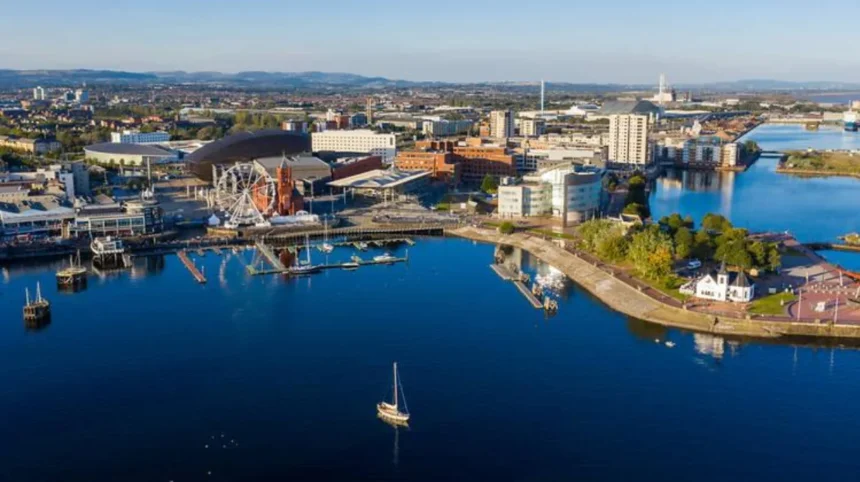
Cardiff faces a significant coastal and tidal flood risk because large parts of the city lie on low-lying land near the Bristol Channel, the River Taff, the River Ely and the Severn Estuary system. Rising sea levels, storm surges and heavy rainfall increase pressure on Cardiff’s flood defences and drainage infrastructure.
- What does coastal flood risk mean in Cardiff?
- Why is Cardiff vulnerable to coastal flooding?
- How do tides and storm surges create coastal flooding in Cardiff?
- What role does Cardiff Bay play in flood protection?
- Which parts of Cardiff face the greatest flood exposure?
- How does climate change affect Cardiff’s coastal flood risk?
- What flood defences protect Cardiff from coastal flooding?
- How are Cardiff’s flood risks managed by public authorities?
- What is the historical background to flooding and coastal management in Cardiff?
- What should Cardiff residents do during a coastal flood warning?
- How does coastal flood risk affect Cardiff’s future development?
- What is the long-term outlook for Cardiff’s coastal flood risk?
Cardiff is the capital city of Wales and one of the United Kingdom’s largest urban areas exposed to combined coastal, tidal, river and surface-water flooding. Understanding this risk requires more than looking at the coastline. Cardiff’s flood exposure is shaped by its geography, rivers, drainage network, tidal conditions and patterns of urban development.
The city has a long history of managing water. Cardiff developed around the River Taff and expanded across low-lying land close to the coast. Areas that contain homes, businesses, roads and public infrastructure now depend on a combination of natural features and engineered flood defences.
Climate change has increased the long-term importance of coastal flood planning. Sea-level rise changes the baseline from which high tides and storm surges operate. Extreme rainfall also places pressure on rivers and urban drainage systems. These connected risks make coastal flooding an important issue for residents, businesses, planners and visitors.
What does coastal flood risk mean in Cardiff?
Coastal flood risk in Cardiff is the likelihood of seawater reaching land and causing damage or disruption. The risk is shaped by high tides, storm surges, sea-level rise, wave conditions, coastal defences and the low elevation of developed land near Cardiff’s waterfront and estuaries.
Coastal flooding occurs when water from the sea reaches areas that are normally dry. This process differs from river flooding, although the two risks can interact in Cardiff.
The Bristol Channel has one of the world’s largest tidal ranges. Tidal range is the difference in water level between high tide and low tide. High tides therefore create a major starting point for assessing coastal water levels around Cardiff.
A storm surge increases water levels above the predicted astronomical tide. Storm surges are caused primarily by low atmospheric pressure and strong winds pushing water towards the coast. When a surge occurs at the same time as a high tide, the combined water level creates a more serious flood threat.
Sea-level rise adds a long-term pressure. A higher average sea level means that extreme coastal water levels begin from a higher baseline. Flood defences and coastal infrastructure therefore require long-term planning and maintenance.
Cardiff also faces interconnected flood risks from the River Taff, River Ely and smaller watercourses. High coastal water levels can affect how efficiently rivers and drainage systems discharge into tidal waters. This interaction is particularly important in low-lying urban areas.
Why is Cardiff vulnerable to coastal flooding?
Cardiff is vulnerable because much of its developed waterfront and surrounding floodplain lies at low elevation beside tidal waters. The Bristol Channel’s large tides, river estuaries, dense urban development and rising sea levels combine to create complex and interconnected flood risks.
Cardiff’s physical geography is central to its flood exposure. The city developed on land associated with the floodplains and estuaries of major rivers.
The River Taff flows through central Cardiff before reaching Cardiff Bay. The River Ely enters the tidal system to the west of the city. These waterways connect inland catchments with coastal waters.
Low-lying land is especially important during extreme water events. Floodwater naturally moves towards lower elevations. Urban development has changed parts of the historic landscape, while roads, buildings and other infrastructure have increased the importance of engineered drainage and flood protection.
Cardiff’s position on the Bristol Channel also matters. The channel’s large tidal range creates substantial differences between low and high water levels. Coastal water levels therefore require close monitoring.
The city also experiences intense rainfall events. Heavy rainfall can overwhelm drainage systems and increase river flows. When high river flows occur alongside elevated tidal water levels, the overall flood management challenge becomes more complex.
The risk is not identical across Cardiff. Flood exposure depends on location, ground elevation, proximity to rivers or tidal waters and the condition of local flood defences.
How do tides and storm surges create coastal flooding in Cardiff?
High tides establish elevated coastal water levels, while storm surges add further water through wind and atmospheric pressure effects. A surge occurring near a high tide produces an extreme water level that increases pressure on Cardiff’s coastal and tidal flood defences.
Tides are predictable movements in sea level caused mainly by gravitational interactions between the Earth, Moon and Sun. Tide predictions allow authorities, ports and coastal communities to identify expected high-water periods.
Storm surges are weather-driven events. Strong winds can push seawater towards the coast, while low atmospheric pressure allows sea levels to rise. These processes create water levels above normal tidal predictions.
The timing of these events is critical. A large storm surge at low tide creates a different risk from the same surge arriving during a very high tide.
Extreme coastal flooding can also involve waves. Waves create additional local impacts along exposed shorelines and structures. Cardiff’s main flood risk system, however, also involves sheltered tidal waters, river mouths and the infrastructure surrounding Cardiff Bay.
Flood forecasting agencies monitor weather forecasts, river conditions, tides and observed water levels. In Wales, Natural Resources Wales provides flood information and warnings for areas facing flooding from rivers and the sea.
What role does Cardiff Bay play in flood protection?
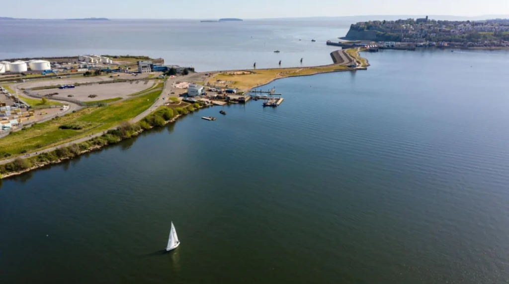
Cardiff Bay is a managed water environment that includes major flood-control infrastructure. The Cardiff Bay Barrage separates much of the bay from Bristol Channel tidal conditions, helping maintain water levels while forming an important part of the city’s wider coastal and flood-management system.
Cardiff Bay was historically a tidal estuary at the mouth of the River Taff and River Ely. The area changed substantially with the construction of the Cardiff Bay Barrage.
The barrage was completed in 1999. It created a freshwater lake and transformed the former tidal bay into a managed water environment.
The structure includes locks and sluice systems that control water movement. It also provides a road and pedestrian crossing between Cardiff Bay and Penarth.
The barrage does not remove all flood risk from Cardiff. Flood management remains dependent on a wider network of structures, watercourses, drainage systems and operational procedures.
Extreme rainfall and river flows still require water management within the wider catchment. Coastal conditions also remain relevant around Cardiff’s estuarine and waterfront areas.
Cardiff Bay demonstrates how major infrastructure can change local water management. It also shows why flood risk must be assessed as a system rather than as a single coastal boundary.

Which parts of Cardiff face the greatest flood exposure?
Flood exposure in Cardiff is highest in locations close to tidal waters, rivers and low-lying floodplains, but risk varies by address. Official flood maps provide the most reliable location-specific information because defences, elevation, water pathways and future planning assumptions differ across the city.
The Cardiff waterfront is an important area for coastal and tidal flood assessment. Cardiff Bay, the lower River Taff and the River Ely form major parts of the city’s water environment.
Low-lying communities and infrastructure near these water systems require continued flood planning. However, being close to water does not automatically mean that every property faces the same level of flood risk.
Flood risk is assessed using mapped flood zones, terrain information, historical records and models of extreme events. Existing flood defences also affect the level of protection in specific locations.
The most useful source for a property-level assessment is the official flood risk service provided by Natural Resources Wales. This information identifies the potential sources of flooding and helps residents understand local exposure.
Three broad sources of flooding often overlap in Cardiff: coastal flooding from the sea, river flooding from watercourses, and surface-water flooding caused by intense rainfall. Examples include tidal inundation near coastal waters, river flooding along the Taff and Ely, and surface-water accumulation on heavily paved urban land.
A complete assessment therefore considers more than distance from the coastline.
How does climate change affect Cardiff’s coastal flood risk?
Climate change increases Cardiff’s long-term coastal flood challenge because rising sea levels raise baseline water levels. Higher coastal water levels increase the frequency and severity of extreme events and require long-term investment in flood defences, planning policies and resilient infrastructure.
Global warming causes sea levels to rise through two major processes. Ocean water expands as it warms, and land-based ice loss adds water to the oceans.
Sea-level rise is particularly important for low-lying coastal cities. A flood event that was previously unusual becomes more significant when average sea levels are higher.
The UK Climate Projections programme provides climate information used by governments and planners to understand future climate conditions. Long-term projections are incorporated into flood and coastal risk planning.
Cardiff’s future flood strategy therefore requires adaptation as well as emergency response. Adaptation means changing infrastructure, planning and management systems to account for expected environmental conditions.
Flood defences have a design life. Sea-level rise means that authorities must consider how protection standards will perform in future decades.
Climate change also affects rainfall patterns and extreme weather. Coastal flooding and intense rainfall can occur within the same wider weather system. This creates compound flood risks.
A compound flood event involves more than one process contributing to the overall impact. In Cardiff, examples include high river flows combined with high tidal levels, or intense rainfall occurring when drainage outfalls face elevated coastal water.
What flood defences protect Cardiff from coastal flooding?
Cardiff uses a network of flood defences and water-management infrastructure rather than one single barrier. The system includes coastal structures, the Cardiff Bay Barrage, river defences, drainage assets, pumping infrastructure, monitoring systems and emergency planning procedures.
Flood defences are structures or systems designed to reduce the probability or consequences of flooding.
Hard defences include walls, embankments, barriers and engineered structures. These physical assets help prevent water from reaching vulnerable land.
The Cardiff Bay Barrage is one of the city’s most prominent water-management structures. River walls and embankments also form part of the protection system in areas affected by watercourses.
Drainage infrastructure manages rainfall and surface water. This includes pipes, gullies, culverts and pumping equipment. These systems are particularly important in densely developed areas where impermeable surfaces reduce the amount of rainwater absorbed by soil.
Monitoring is another essential component. Water levels, weather forecasts and river conditions provide information used for flood forecasting and operational decisions.
No flood defence system provides absolute protection against every possible event. Flood risk management therefore combines physical infrastructure with planning, forecasting, maintenance and public preparedness.
How are Cardiff’s flood risks managed by public authorities?
Flood risk in Cardiff is managed through cooperation between public authorities responsible for forecasting, planning, drainage, emergency response and infrastructure. Natural Resources Wales, Cardiff Council and Welsh Government policies each support different parts of the flood and coastal risk management system.
Natural Resources Wales is the principal environmental body responsible for many flood risk management functions in Wales. It provides flood warnings and information for flooding from rivers and the sea.
Cardiff Council has important responsibilities relating to local flood risk management, land-use planning and infrastructure within the city.
The Welsh Government sets national policy for flood and coastal erosion risk management. This policy framework guides long-term investment and adaptation.
Flood risk management follows a structured approach. Authorities assess hazards, identify vulnerable locations, maintain infrastructure, improve defences and prepare emergency procedures.
Planning is also important. New development requires consideration of flood risk. In Wales, planning policy and technical guidance establish requirements for assessing whether development is appropriate in areas exposed to flooding.
Sustainable drainage systems are another part of modern water management. Sustainable drainage systems, often called SuDS, manage rainwater closer to where it falls. Examples include permeable surfaces, swales and detention basins.
These measures reduce pressure on conventional drainage networks and help manage surface-water flooding.
What is the historical background to flooding and coastal management in Cardiff?
Cardiff’s flood history is linked to its development on river floodplains and a major tidal coast. Industrial growth transformed the waterfront, while modern projects such as the Cardiff Bay Barrage reshaped water management and increased the importance of coordinated flood planning.
Cardiff grew rapidly during the nineteenth century as a major coal-exporting port. The construction of docks and associated infrastructure transformed the city’s waterfront.
Historic development changed the relationship between land and water. River channels, docks, embankments and drainage systems were altered to support industry and urban growth.
Flooding has remained a recurring environmental challenge because the city continues to occupy land connected to major rivers and tidal waters.
The Cardiff Bay development represented one of the most significant modern changes to the local water environment. The barrage altered tidal conditions within the bay and created a managed freshwater body.
Historical experience is valuable for flood planning, but future risk cannot be assessed only through past events. Climate change changes sea levels and weather conditions, while urban development changes how rainfall moves across land.
Modern flood management therefore combines historical records with scientific modelling and future climate projections.
What should Cardiff residents do during a coastal flood warning?
Cardiff residents should check official flood information, follow emergency instructions and prepare before water reaches their area. Flood warnings provide location-specific information, while personal preparedness reduces disruption and supports safer decisions during rapidly changing flood conditions.
Flood warnings are an important part of public safety. Natural Resources Wales issues information and warnings for areas affected by flooding from rivers and the sea.
Residents should identify their local flood exposure before an emergency occurs. Official flood maps and warning services provide the starting point.
A household flood plan should identify safe actions and essential contacts. Important preparations include knowing how to receive official alerts, protecting important documents and understanding safe routes.
People should never enter floodwater unnecessarily. Floodwater can contain hidden hazards, strong currents, contamination and damaged infrastructure.
Drivers should avoid attempting to cross flooded roads. Water depth and road conditions are difficult to judge during an active flood.
Businesses also require flood plans. A business plan should address staff safety, data protection, stock, utilities and operational continuity.
Preparedness is especially important because flood events can involve several sources. Coastal water, river flows and surface-water flooding require different local responses.
Explore More Area Guide
Why Does Cardiff Flood? Causes, Risks and Flood Prevention
Cardiff Climate and Weather Guide: Temperatures, Rainfall and Seasons
How does coastal flood risk affect Cardiff’s future development?
Coastal flood risk directly influences Cardiff’s future development because homes, transport networks and public infrastructure require long-term protection from rising water levels. Planning decisions increasingly depend on flood evidence, resilient design, sustainable drainage and adaptation to future climate conditions.
Cardiff continues to develop as a major capital city. Development creates economic and social benefits, but new infrastructure must account for environmental risks.
Flood risk assessment is a key part of responsible planning. Developers and planning authorities examine whether a site is exposed to coastal, river or surface-water flooding.
Where development proceeds in areas with identified risks, design and infrastructure requirements help manage exposure.
Resilience is an important concept in future planning. Resilient infrastructure continues to provide essential functions during disruptive events and recovers efficiently after them.
Transport is particularly important. Roads, rail connections and utilities connect communities and support the wider Welsh economy. Flood disruption can therefore have consequences beyond the immediate flooded area.
Long-term adaptation also requires regular review. Flood maps, climate projections and infrastructure standards are updated as new evidence becomes available.
The future challenge for Cardiff is not simply building higher barriers. Effective flood management combines engineering, environmental planning, forecasting, drainage and informed development decisions.
What is the long-term outlook for Cardiff’s coastal flood risk?
Cardiff’s coastal flood risk will remain a major long-term planning issue because sea-level rise increases pressure on low-lying urban areas and flood defences. Continued monitoring, investment and climate adaptation are essential to protect communities, infrastructure and economic activity.
The long-term outlook is shaped by environmental change and human decisions. Sea levels, extreme weather and land use all affect future flood exposure.
Existing defences require inspection, maintenance and periodic improvement. Infrastructure designed for current conditions must also be assessed against future water levels.
Natural and engineered solutions both have roles. Engineered structures provide direct protection, while sustainable drainage and environmental management reduce pressure elsewhere in the system.
Accurate information remains essential. Residents and businesses need clear flood maps, warning systems and emergency guidance.
Cardiff’s experience also illustrates a wider challenge facing coastal cities across the United Kingdom. Urban areas built near estuaries and low-lying coasts must manage the interaction between the sea, rivers, rainfall and changing climate conditions.
Understanding Cardiff coastal flood risk therefore begins with geography but extends into planning, infrastructure and climate adaptation. The city’s flood management system protects communities today while long-term policies prepare for changing environmental conditions.
For residents, the most important action is to use official, location-specific flood information rather than relying on general assumptions about distance from the coast. For policymakers and developers, the central task is to ensure that Cardiff’s growth remains compatible with the long-term realities of coastal and tidal flood risk.
Is Cardiff at risk of coastal flooding?
Yes. Cardiff faces coastal and tidal flood risk because parts of the city are low-lying and connected to the Bristol Channel, Cardiff Bay, the River Taff and the River Ely. High tides, storm surges and rising sea levels all influence long-term flood risk.